Are you ready to go to the Antarctic?

Vicky, my wife, and I took this trip to Antarctica – the White Continent - in 2008.  The trip included Buenos Aires, Argentina; Tierra Del Fuego; the Chilean fjords; Patagonia; Santiago, Chile; and Easter Island.  We were gone from January 23rd to February 14th, 2008.  The Antarctic portion of the trip was from January 25th to February 2nd.  It was summer time in Antarctica, but you would never know it to be there.

My pictures really didn’t come out very well and don’t do the Antarctic justice.  In fact, many of them really didn’t come out at all – with so much snow and brightness.  But the thing is that when you take about 1500 pictures, some are bound to come out relatively okay, or at least well enough to give people some idea of what it was like.

I’ve included a few pictures here just to give you some idea of what’s to come.

Bill Bosworth

Ushuaia

We flew from San Jose to LA, then to Lima, Peru, then to Buenos Aires, Argentina, and then to Ushuaia, Argentina to reach our ship for our journey to the Antarctic.  It was four flights and a whole lot of flying and airport time but we made it.  We departed Ushuaia by ship.

Ushuaia is the southernmost city on Tierra Del Fuego, an island which is off the southern tip of the American continent: i.e. the end of the road.  It also included the southernmost yacht club, the southernmost bar, the southernmost national park, and the southernmost ice cream parlor – all of which we visited while in Ushuaia.  Ushuaia was a very nice city with friendly people and lots to do and see.

In the first photo, you can see part of Ushuaia.  I took this picture from our ship as we headed out of the harbor for Antarctica.

The second photo was taken at the Tierra Del Fuego National Park.  It gives you an idea of what the end of summer looks like in Tierra Del Fuego.  It has rivers, lakes, glaciers, beech tree forests, sphagnum moss peat bogs, beaver dams, and Upland geese (all of which we saw).

The third photo was also taken in the park.  We left Ushuaia via the Beagle Channel which was quite calm and headed for Drake’s Passage and what we were told was the roughest stretch of water in the world.

The main thing was that our voyage to the Antarctic was underway.

Drake's Passage

Drake’s Passage has the reputation for being one of the worst, if not “the worst”, stretches of water in the seagoing world.  It has to do with a number of factors.  The water close in on the Antarctic continent circles in a counter clockwise direction.  But the water further offshore, circulates the other way, due to prevailing winds.  Also, the oceans around Antarctica are wide areas with the exception of the area between Cape Horn and Tierra Del Fuego and the Antarctic Peninsula, which is a narrow area and forces water through a much smaller space.  Add to that the fact that the cold Antarctic meets the warm southern oceans and the Pacific meets the Atlantic and the Indian oceans and throw in icebergs floating north from Antarctica and Drake’s Passage can be hell on board a ship.

According to our ship’s crew and guides, our trip (about 36 hours) across Drake’s Passage was one of the nicest they ever experienced.

The first picture is just one of the water – I was really impressed with the shade of blue.  Also, our ship’s crew told us that this was “flat water”, at least by Drake’s Passage standards.

The second picture in the Passage was what we expect was the Polar Front or the Antarctic Convergence.  The convergence is the boundary where the sub-Antarctic water meets the warmer water of the southern oceans.  The line moves back and forth between 50 degrees and 60 degrees south latitude and can only be determined for certain by measuring the water temperature.  The water temperature can change 5 degrees C over a distance of only a few miles or a few tens of miles.  The convergence is usually an area of heavy fog and you can see that coming in the second photo.

You can see the change in color when we got into the Antarctic by looking at the third photo.  It was a black and white world much of the time down there.  Welcome to summer time in the Antarctic.

Antarctica

I’ll give you a little bit of general information on Antarctica which is called the White Continent.

Antarctica is not a country.  In the early part of the 20th century, seven nations made territorial claims, but all claims were put aside in the Antarctic Treaty signed in 1961.  So today, no one owns it – or conversely, everyone owns it.

Antarctica is the fifth largest of the world’s seven continents.  It’s about half as big as the USA and about twice the size of Australia.

Antarctica had no native population and today still has no permanent residents.  No one had seen Antarctica before 1820 and today it only has visitors which are measured in thousands in summer and hundreds in winter at the various scientific bases.

More than 99 percent of Antarctica is covered with ice.  Antarctica contains about 90 percent of the world’s ice.  It contains about 70 to 75 percent of the world’s fresh water.  The ice is thick making the average elevation of the continent about 7500 feet.  So on the Eastern side, it might be flat, but it’s still quite a high elevation.

Antarctica is both the coldest and windiest continent.  The lowest recorded temperature was -128.6 degrees F on July 21st, 1983.

A French base recorded the wind speed at 200 miles per hour in July 1972.

The highest temperature ever recorded in Antarctica was 59 degrees F.  The highest temperature while we were there was 41 degrees F.

Antarctica is considered a desert.  In the interior of the continent, the average annual precipitation is about 2 inches which is less than in the Sahara Desert.  There is, however, very little evaporation, so the relatively little snow that falls doesn’t melt, it just builds up.  It has continued to build up for thousands of years into enormously thick ice sheets.

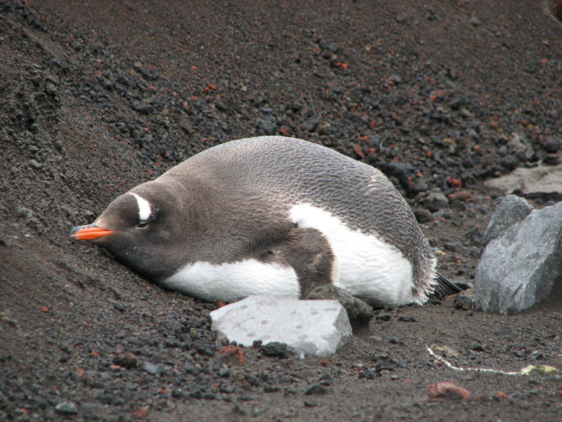
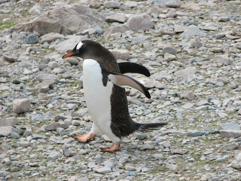
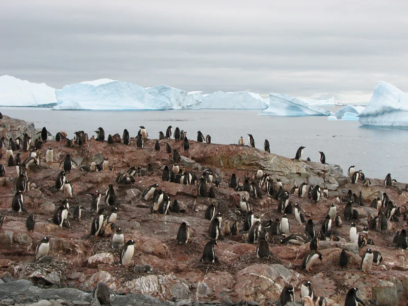
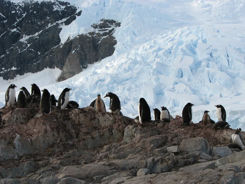
Antarctica has penguins and no polar bears.  The Arctic has polar bears and no penguins.  Penguins are only in the southern hemisphere.

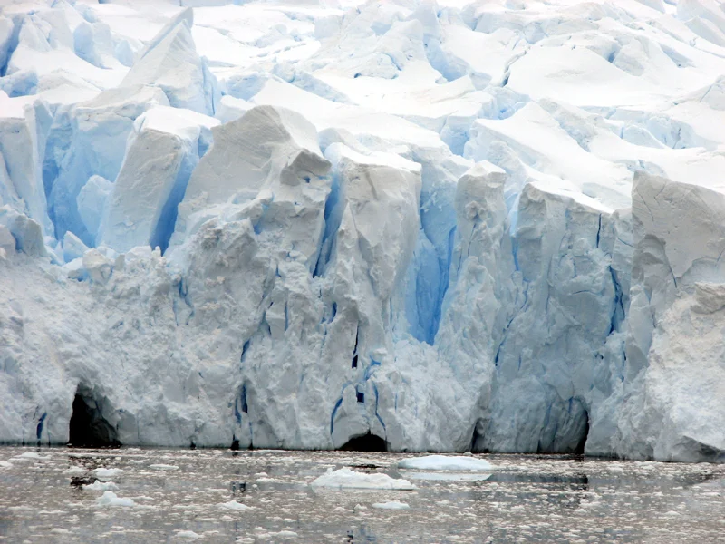
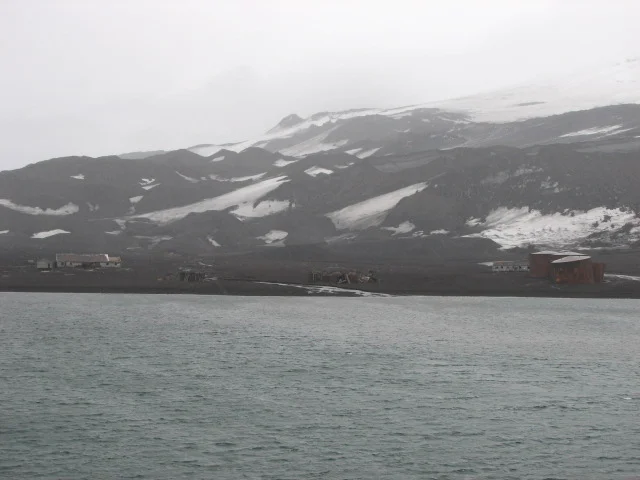
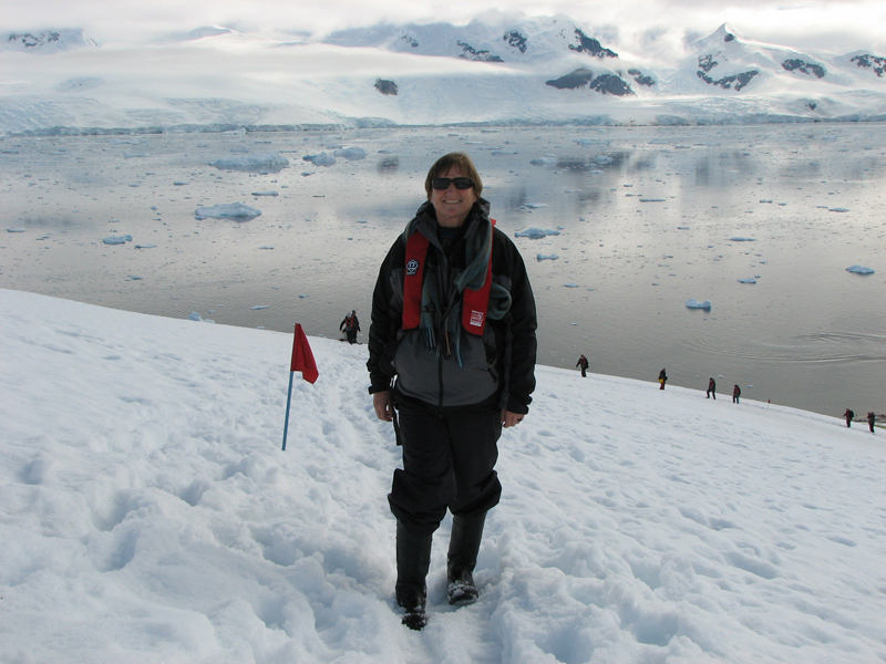
I have included three more “general” pictures that were typical sights in the Antarctic. (snowy mountains, “calving” glaciers, & icebergs)

Going Ashore

We had eight planned shore landings in the Antarctic and we managed to go ashore seven times.  We met a couple at the Lima airport that took the exact same trip we were on and they only managed to get ashore three times, so we were lucky with our weather this trip.

I’ll give you a couple of examples of what people talk about when they talk about “weather” in the Antarctic.  On June 5, 1963 at the “Eights Station” research station, the surface temperature changed 185 degrees F in 96 hours.  At that same station on June 10, 1963, the surface temperature changed 97 degrees F in 12 minutes.  Granted, these are some extremes, but in Antarctica, they are also possible.

So going ashore was a matter of being prepared at all times.  Before any tourists were allowed to go ashore, the excursion staff went ashore with survival supplies, just in case the weather changed quickly and some of us got stuck on shore.  Survival supplies included body suits, tents, food and water, shovels, axes, etc.  You can see some of these supplies onshore in the first photo.

We went ashore in small hard plastic boats which carried eight passengers and the boat operator.  We went out a door on the second deck and went down a stairway to first deck or water level.  You can see this in the second photo.  In this picture, passengers were coming back onboard our ship.

Our shore landings were “water landings”.  The boats usually stopped twenty to thirty feet off shore and we waded ashore.  The water was shallow.  I think the water only went over my boots on two occasions and yes, wow that’s cold.  The worst problem was that sometimes the shore was very rocky and sometimes the rocks were very slippery or covered with mosses and the like.  You can see one of our shore landing in the third photo.

Deception Island

Our first landing was on Deception Island which is south of the South Shetland Islands and north of the Antarctic Peninsula.  Our landing was in Whaler’s Bay which is an old volcanic caldera where one side of the caldera collapsed and let in the sea.  It’s round and the rock is very volcanic.  The entrance to the bay is through Neptune’s Bellows which is a narrow opening where the wind really howls.

Deception Island was the home to many whaling ships starting as early as 1905.  Later, it also housed whale processing factories for many years.  That ended when the volcano erupted between 1967 and 1969 and mudslides destroyed the factories. 

The first photo is from the deck of our ship as we awaited our turn to go ashore.  The Antarctic Treaty and agreements with the tour operators and all countries involved in Antarctica only allows 100 tourists at a time to be on the entire continent.  All the buildings on shore are remains from the whale processing factories.

In the second photo, you can see me scribbling some journal notes.  The people in the brightly colored coats are part of our expedition staff.  If you look at our landing spot on the bay, you can see the steam from the geothermal heated water.  The water wasn’t scalding to the touch, but it was very hot.  A few people went swimming in the bay right next to the hot water outlet.  The air temperature wasn’t that cold on the ground (about 32 degrees F) but it was raining at times with some sleet as well.

The third photo was the first penguin that we saw.  This is a Gentoo penguin and a very fat one at that.  My guess is that he just gorged himself with krill and is waiting for digestion to happen.  I also threw this photo in so you could see the ground which was mostly crushed red and black volcanic rock.

Deception Island Whaling

Antarctica had, and to some degree still has, huge wildlife resources.  The main ones as far as man and his economic activity was concerned were whales and seals.  Hundreds of thousands were taken by the whalers and sealers for oil and other products.  This has almost entirely stopped now since the whale and seal populations were greatly depleted to below economic viability.  Tourism has taken over as the primary economic activity in the Antarctic. 

The three pictures here represent remains of the old whale processing factory facilities from back in the early 1900s.  Antarctica and the tourist industry strongly protects remains such as these.  Of course, there’s not all that much to preserve in Antarctica.

Dec Is. W 2.jpg

Cuverville Island

Our next shore excursion was to Cuverville Island.  Cuverville had some interesting sights and action happening on the island including whale bones, penguins, glaciers, creeks, grounded icebergs, steep cliffs, snow, mosses and lichens.

Our landing spot was on the end of the spit of land on the left in the first photo.  The photo was taken from our ship as others were heading into the island.  Our small boats had to weave their way through the icebergs to get to the landing location.

In the second photo, we had hiked up the cliff which you can see behind Vicky.  It continues to go up rather steeply.  You can also see a glacier behind Vicky in the photo and of course, a gentoo penguin colony.

I’m kneeling near some old whale bones on shore in the third photo.  These bones seemed large at the time, but we learned from seeing others that these were actually on the small side.  Also, if you look above me and slightly to the right, you can see a penguin “porpoising” out of the water – nice catch by Vicky on that photo.  The penguin standing right behind me looks a bit bored.  I suppose he decided that I wasn’t “Mr. Excitement.”   


Gentoo Penguins

We are still on Cuverville Island.  This is my introduction to the penguins.  These are Gentoo penguins.  Gentoo penguins are one of three types of penguins in the “brush tailed” penguin family.  Major penguin activities include sitting around the nest and colony, going between the colony and the ocean, and catching food and goofing off in the ocean. 

The first photo shows a Gentoo walking past me.  You can hopefully see why the name brush-tailed penguins by looking at its tail.  The brush-tailed penguins use their tail sort of like a third leg.  They use it to balance themselves when they walk.  With two legs and their tail for stability plus their two arms waving back and forth for balance, these penguins are very stable and walk very quickly over all terrain.

The second photo has some 18 or so penguins in it.  I show you this because the Gentoo penguins were walking up and down this steep rocky slope like they were walking on flat ground.  They walk, run, hop, and slide in varying combinations but they move right along no matter how steep or rough the terrain or whether they are going up hill or down hill.  They also tend to follow established routes or “penguin highways” which you can sometimes see by their rutted and usually dirty trails in the snow.

Feeding and playing in the water is a major activity for the penguins.  I could have watched these penguins for hours as they dove into the water and hopped out up onto an iceberg.  They came out of the water like a long distance ski jumper coming off of the jumping chute.  In the third photo, you can see a still shot, but I needed video to really capture the fun and frolic happening here.

Gentoo Penguin Colonies

This is still Cuverville Island.  Penguin colonies in an area can range from dozens to hundreds.  Some penguin colonies have a half million penguins or more.  The gentoo penguin colony on Cuverville Island was large and covered quite a range of locations.

In the first photo, these penguins were actually quite close to the water which I thought was a great location.  It meant that these penguins didn’t have too far to go between their nests and getting some food.  But according to some of our expedition staff, these are not the preferred locations.

In the second photo, you can see some other colonies and these are quite a ways up the steep cliffs.  I would say that some of them were as much as 150 to 200 yards up the cliffs.  Our expedition staff said that these were usually the first spots taken when the gentoo penguins came to start nesting.  It seems that the nesting sites farther from the water have been safer over evolutionary time.  I suppose it would be harder for a seal or Orca to get them and also less likely for a baby to wander into the water, so it probably makes sense.  It just seems like such a long and hard hike every time the penguins need to get some food.  I’m zoomed way in on this photo as it’s up the hill quite a long distance.

The third photo is just a close up of a few nesting birds.  Brush-tailed penguins build their nests out of small rocks and pebbles.  They are frequently adding more rocks to their nests to keep them built up.  Where do they get the rocks?  They mostly steal the rocks from other penguins nests which never goes over very well with the other penguins.

Gentoo Penguin Behaviors

This is one more penguin post from Cuverville Island.  I just thought I would show a few of the frequent penguin behaviors observed.

The penguin in the first photo is delivering a new rock to the nest, no doubt stolen from a nearby nest of another penguin.

Gentoo B 1.jpg

My second picture doesn’t really capture the behavior very well, but I’ll tell you about it anyway.  Penguins have a “bowing” behavior.  The mom and dad bow to each other before they change shifts for tending the nest and baby.  The parent and baby also do this bowing behavior when it’s time to eat.  This picture doesn’t really show it, but that’s what was going on when I took the photo.

Much of a baby penguin’s time is spent sleeping.  In the case of gentoo penguins, they lay in the nest with the parent standing over them and cuddled up next to them.  You can see this in the third photo.


Ice Blue

The blue color in some of the Antarctic ice was truly a sight to see.  I’ve heard the term “ice blue” all my life and I’ve always wondered where the term came from.  For example, “ice blue aqua velva” after shave lotion, I used to wonder why was it called ice blue.

The science is the same as with why water sometimes looks blue.  It has to do with light and our perceptions of certain bands of light and all that.  Our expedition crew said that it was from perfectly formed ice with an absence of air bubbles.  They said it was usually found in the old ice that was very compacted.  Another expedition staff member got upset with that explanation and told us that the ice didn’t have to be old to be blue, just very dense and lacking oxygen.  I asked her how ice might get to be very dense and lack air bubbles or oxygen and she said that it was usually from the snow and ice building up over many years in glaciers and due to the weight and movement down the mountains.  In other words, usually the old ice was the very blue ice.

I’ve already sent you a few pictures of some blue ice, so I’m going to include a few of the more unusual of my ice blue pictures.

The first photo is of a glacial mountainside and the whole mountain was tinted with a bluish light.

The second photo is an iceberg but not with that bright blue ice, but rather with a bluish tint to the whole berg.

The third photo is a glacier we were passing which had that deep blue color in the interior of the glacier.


Blue Icebergs

Following up on my ice blue message, the best of the blue ice for me was the icebergs.  We were told that when the ice is very blue, the ice is probably at least 10,000 years old.  I don’t know how true that is, but if so, we saw lots of very old ice.

I just thought that the icebergs floating by with so much blue ice to them were spectacular to see and to enjoy.

Icebergs, we were told, generally have 10% to 30% of their mass above the water, and conversely, 70% to 90% of their mass below the water (i.e. the tip of the iceberg).  The icebergs that were so impressive to see were the ones with so much blue ice below the water.  The icebergs in these pictures are all regular icebergs from glaciers that have “calved” into the ocean.  “Calving” is the term that is used when a glacier drops part of it’s ice off the land shelf and into the water – becoming an iceberg.

In the first photo, it’s a small size glacial iceberg (but bigger than our house) with a large amount of old ice down below the water line.

The iceberg in the second photo is a glacial iceberg that got top heavy and flipped over in the water.  I zoomed in to capture the blue color, but if you look at the top of the photo in the background, you can see the white snow and dark hillside for contrast.

The third photo is a very small iceberg, maybe the size of my living room but again, the color of the ice in the water is fantastic.


Andvord Bay

We next headed into Andvord Bay which is a bay of the Antarctic Peninsula itself.  The land around the bay is mountainous with rows of alpine glaciers all along its sides.  Once in the bay, we were completely surrounded by glaciers.  There wasn’t a bad view in any direction.  We spotted several pods of Orcas (or killer whales, but really in the dolphin family) in the bay and they swam along side our ship.

I wasn’t nervous about Andvord Bay, but it was the first time that we really got into some icy waters.  The farther we went into the bay, the more we were plowing our way through the ice.  Most of it was very small icebergs, but a few were attention-getters.

The first photo is not a great one and I took it in the distance.  It’s what all the land masses around the bay looked like.  You can see the glaciers at the water’s edge with one large glacier going up to the left and another glacier going up to the right.

In the second photo, this glacier is quite large and it appears to calve frequently.  You can see many bits of glacier or icebergs in the water that have come from this glacier.

You can see why I was a bit concerned in the third photo.  Our ship had to propel through this ice.  Most of it was small size, but if you look at some of the glaciers farther back in the photo, they were much bigger and of greater concern.  While it’s hard to tell from this photo how large these icebergs are, I can tell you that many of them made quite a loud bang when we struck them with our ship.  We were constantly hitting these small bergs on our way through the bay.

Neko Harbor

We reached the end of Andvord Bay which is called Neko Harbor.  It was named Neko Harbor for an old whaling ship that anchored here in the early 1900s.  This was our third land excursion and our first time stepping on the Antarctic Peninsula, or mainland Antarctica.

Our expedition crew was very adamant to us that we needed to get off our landing boats and immediately move to higher ground.  They told us that Neko Harbor was one place with glaciers that constantly calved.  When a big glacier has a big calve, it can send a wave (like a small tsunami) that is fifteen to twenty feet high across the bay. 

You can see the end of Andvord Bay and Neko Harbor in the first picture.  If you look on the lower portion of the picture and on the left side, you can see one of our boats landing and people starting to walk ashore.   The boat and people look a bit insignificant in the photo.

You can tell how bad I was at following directions by looking at the second photo.  Just as I came ashore, a large Weddell seal gave me a high five (a raised flipper) and I had to stop and take a picture of it.  After I got the photo, I moved to higher ground.

The third photo was something that I found interesting.  We all know what white snow is.  I suspect that most of us know what yellow snow is.  But who knows what red snow is?  Look at the third photo. 

The Antarctic is a harsh environment.  The red color comes from algae that has evolved over time to be able to grow at extremely low temperatures, but while algae can grow at those low temperatures, it can’t produce chlorophyll which is what makes plants green.  If you look at the upper edge near the rocks, you can see a few places where there was enough sun and warmth to turn the algae green.

Neko Harbor Glaciers

The glaciers at Neko Harbor were probably the best ones that we saw.  The best part was that we were on the Antarctic mainland and we got to climb quite a ways up a glacier.  It probably took us thirty minutes to hike up to the top of where our expedition staff let us go.  It was an incredible view from the glacier.  We sank into the snow above our boots a few times but relished the opportunity.

For my Neko Harbor glacier pictures, I decided to just show you one direction.  All three photos are of the same area and I just zoom in on the bottom of the glacier over the course of these three photos.

In the first photo, we had hiked quite a ways up the glacier and are looking back to one side of the harbor.  You can see that the whole mountainside is one glacier after another one.  If you look at the lower left of the first photo, where the glacier hits the bay, that’s where I zoom in on the next two pictures.

You can see in the second photo that this glacier is “calving” regularly.  You can see the breaks in the ice pack and see where the chunks will separate and fall off into the bay to become icebergs.

I just zoomed in again for the third photo.  You can see how big some of the splits are within the glacier.  You can also see how blue the ice is both within the glacier and in the water.


Glacier Hiking

We hiked up a glacier at Neko Harbor and it was quite the experience.  It’s really hard to get a true feel for the place by looking at these pictures.  That’s because there was so much going on that you can’t see.  First of all, there was the wind which blew very hard at times.  Then there was all the noise.  There was a lot of noise here.  The glaciers were calving frequently.  Sometimes, they were not that loud, but at other times, it sounded like a clap of thunder about ten feet away.  I think that twice I covered my ears and ducked when a glacier calved.  Then there were thousands of penguins which made lots of noise.  Also, as we stood on the glacier, it sounded like a river, not a small creek but a river, was running right underneath our feet.  Another part of the experience was the smell.  Thousands of penguins in a small area don’t smell like a rose garden.  So while the pictures are good ones, they only show a part of the whole experience.

Vicky is about a third to half way up the glacier in this photo.  You can see Neko Harbor or part of Andvord Bay behind her.  You can also see all the glaciers around the harbor and all the icebergs in the bay.  The red flag was our trail marker to follow up the glacier.

The next photo was taken from about where Vicky was in the first photo.  It shows the rest of our hike as you can see some of our fellow travelers up ahead of us on top of the glacier.  The weather also cooperated as the sun and some blue sky came out for us.

The third photo is also about half way up our hike.  We were surprised to see some penguin colonies that high up the glacier.  They had a long walk between the bay and their nests but they just went about their business.  The high up colonies are usually the first ones that get occupied as they have evolved as the safer places for the penguins to nest.

John Muir, the great naturalist said, “To dine with a glacier on a sunny day is a glorious thing and makes feasts of meat and wine ridiculous.  The glacier eats hills and drinks sunbeams.”  Vicky and I dined with glaciers on a sunny day in Antarctica this day.

More Neko Harbor

This will be it for Neko Harbor.  We saw lots of penguins sliding down the glaciers – as opposed to walking down.  They do it to conserve energy but to us, it looked like a lot of fun.  You can also see a bit of green algae in the upper portion of this picture.

This second photo is along the shore line.  The beach area was littered with sculpted chunks of ice.  It didn’t bother the penguins as they just scooted around them on their way to their nests.

I’m showing off in the third photo.  I decided to take an iceberg home with me.  I didn’t get it all the way home, but a glacier makes great cocktail ice.

Deck Watch

One of our big concerns before we went to Antarctica was how cold it would get and how would us Californians handle it.  We went out and purchased long underwear, both tops and bottoms, extra gloves (2 pair each), hats, and more.

We focused on our shore excursions as the critical need for warmth and protection.  We were wrong.  When we were on shore, we were mostly walking and frequently walking up steep hills so it was really not too bad.  At many stops, I ended up taking off my coat and not wearing my hats and gloves.

Where the cold front became an issue was standing out on the deck of our ship while we cruised through the Antarctic.  There was always a breeze, even if it was only from the movement of our ship.  Sometimes, that was multiplied by the local wind.  We also were usually standing around, not walking, and even when we walked, it wasn’t up hill.

We could go inside any time we wanted and get warm, but sometimes I stayed out for hours, enthralled with the scenery.  We also stayed out several times for hours watching whales swimming along side our ship.

These photos are out of sequence for our trip.

Vicky was a bit more of a fair weather deck watcher than I was.  She liked it when the sun was out like in the first photo.

Vicky did rough it a bit such as in the second photo which was in the Lemaire Channel and with some weather.  You can also see a seal taking a snooze on a passing iceberg in that photo.

As for me, I was hard core.  If we were passing anything of note, I was out on deck.  You can see the evidence of that in the third photo.

If you look at the sea, we were locked in almost solid icebergs at that point along with some really cold wind and weather.

I was wearing all my gloves, hats, and socks on that day.

Humpback Whales

We saw over twenty-five whales on our trip.  Most of the whales were Humpback whales and most of them we saw in the Antarctic.  They swam slowly, most likely feeding on krill (shrimp), and our ship followed them along on several occasions.  Sometimes, we followed pods along for several hours, usually one or two at a time.

It was exciting, but it was hard to get good pictures.  We needed our son Andrew’s camera that clicks repeatedly.  But the real fun was mostly in the watching.  Vicky and I saw a pair of whales breach almost completely out of the water right in front of us and we just stood there and admired it.  They spouted and fluked and seemed to be enjoying the day.

These photos are not very good, but at least I got a few shots for all the time I spent out on deck in the cold wind.