Are you ready to go to Scandinavia?

Are you ready to go to Scandinavia?

We went to four countries this trip: Denmark, Norway, Finland, and Sweden.  One thing we learned is that Scandinavia is the three countries of Denmark, Norway, and Sweden.   We also learned that there are five Nordic countries: the three Scandinavian countries plus Finland and Iceland.  So Finland is not a Scandinavian country but it is a Nordic country.

In looking at the map, the four countries that we visited look so close together and interwoven but the differences are primarily the languages.

IF you want to learn more, come along for the trip.  I’ll take it in the order that we traveled it.  This trip was from May 5th to May 29th, 2019.  It was another OAT trip (Overseas Adventure Travel – our go-to travel company).

We had lots of surprises on this trip and I’m sure you will enjoy some of them as much as we did.  Pete and Nora Garrod joined us on this trip, so it was another family affair. Pete is my wife’s (Vicky) brother.

Here are a few highlights to go with the photos.

1.     This is not a photo of one of the icons of Denmark, but for me having a “Danish” in Denmark was quite a delight.

001-DSC01383.jpg

2.     We traveled the Norwegian coast on a ship from Bergen to Kirkenes and we enjoyed many sights such as this.

002-DSC02253.jpg

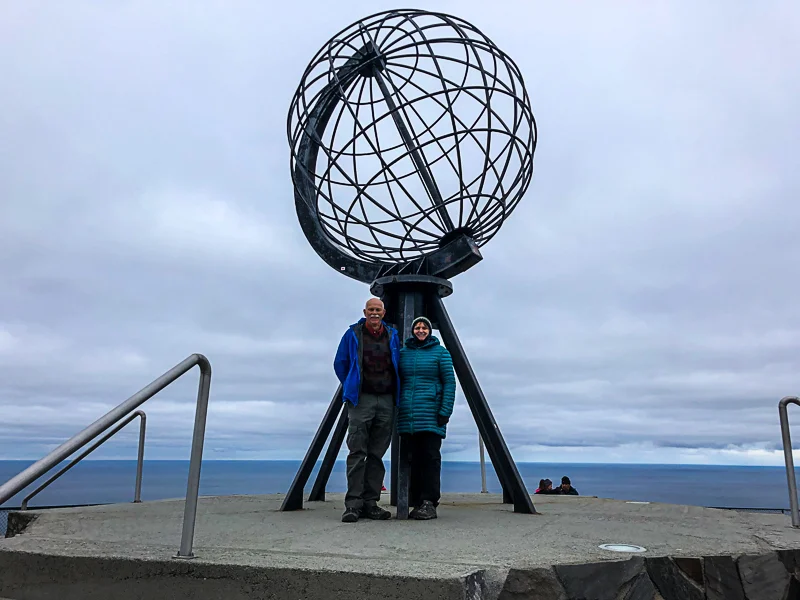
3.     This is at the North Cape which is at the top of Norway and the northern most accessible point in Europe.

003-IMG_3362.jpg

4.     Vicky is feeding some reindeer at a Sami family reindeer farm in northern Finland. 

004-DSC02639.jpg

5.     This is in Stockholm Sweden.  The building just to the right of this photo is the Nobel Museum.

005-DSC03015.jpg

6.     A map of the countries we visited.

scandinavia-map.jpg

Copenhagen, Denmark

Welcome to Copenhagen, Denmark.  We learned while there that in Danish, it’s called Kobenhavn and pronounced quite differently than we pronounce it.  Most of our short time in Denmark was in Copenhagen.

Copenhagen was founded in the 12th century.  It was a fishing village and a bishop in the early days erected a fortress to protect it.  The Copenhagen Castle was constructed in 1376 and King Erik moved here in 1416 making it the capital of Denmark.  Denmark ruled Norway and parts of Sweden for long periods of time and they had many wars with the Swedes as Denmark and Sweden were the two real powers in this area for hundreds of years.

Copenhagen went through many up and down cycles over the centuries with wars, fires, bubonic plague, religious fights, the arts, and economic changes all making impacts.  All of that, plus a lot of water and waterways, makes Copenhagen a very interesting place to visit. 

I’ll start our visit to Copenhagen with some of the iconic and older sights.  The first photo is the Harbor area.  This is the view that I most see when finding information on Copenhagen.  It’s sort of the iconic view of Copenhagen.  Our hotel was about two blocks from here and we passed here frequently on our travels around Copenhagen.  We also had several meals here.  The second photo is the icon of Denmark, the Little Mermaid.  This statue is at Langelinje Pier and in the harbor.  It was unveiled on Aug. 23, 1913 as a gift from a Copenhagen brewer.  It was inspired by the Hans Christian Andersen fairy tale.  Vicky is doing her best little mermaid impression.

006-DSC01140.jpg
007-IMG_6874.jpg

The third photo is Amalienborg, home of the Danish royal family.  The Royal Family found themselves homeless back in 1794 when the Christiansborg Palace burned down.  They moved here as a temporary measure until reconstruction but at some point changed their minds because they liked it here so much and they have been here ever since.  There are four identical palaces here with different royals living in different palaces.  This photo is currently the Queen’s Palace.  The courtyard is between the palaces and the center of the square features a statue of Amalienborg’s founder, King Frederick V.  The queen was not in the day we visited but we got to watch the changing of the guards.

008-DSC01251.jpg

The Borsen building in the fourth photo was built in the 1620’s and is one of the oldest buildings in Copenhagen.  King Christian IV built it as an official trading center.  It’s been a stock exchange, marketplace, and today is the head office of the Danish chamber of commerce.  It’s still a beautiful building and a part of what makes Copenhagen such in interesting place to see.

009-DSC01232.jpg

The Church of Our Saviour is in the last photo.  It’s a baroque church most famous for its helix spire with an external winding staircase that can be climbed to the top.  We seemed to see this spire over and over from many points in Copenhagen and it looks so unique.  Copenhagen actually has lots of spires and they really helped us with directions as we walked our way around town.  We never walked up this spire as we never got to this church, though we traveled all around it multiple times.

010-DSC01235.jpg

Modern Copenhagen

Most of the time that we visit old cities, we tend to focus on the “old town” areas and the older aspects of the city.  You can’t really do that in Copenhagen.  As we traveled the older parts of town, new buildings were everywhere.  And I would say that many of the new buildings were very interesting from both architectural and many other aspects.  I’ll try to convey some of those things in this post.

The Copenhagen Opera House is the first photo.  It’s also the national opera house of Denmark.  It was constructed from 2001 to 2004 at a cost of over $500 million US dollars.  It’s located on the island of Holmen right in central Copenhagen.  We passed by this building both from the front and the rear but never got to go inside it.  It looks quite different from different angles but it is a striking building from all angles.

011-DSC01212.jpg

The Silo is the second picture.  As our country struggles with a housing crisis, we might learn some things from the Scandinavians.  The Silo was formerly a grain silo.  Today it is a residential building with 17 stories of apartments and public areas.  On top of the building is the Restaurant Silo with a 360 degree view of Copenhagen with floor-to-ceiling windows.  This building is in an old industrial harbor area, now an upcoming neighborhood.  They could have torn down the grain silo and replaced the entire building but they chose a different idea.   

012-DSC01160.jpg

A Copenhagen waste-to-energy recycling plant is in the third photo.  It was built to introduce a more sustainable waste management to the city.  A smokestack will emit a ring of smoke every time a ton of carbon dioxide is released as a visual reminder of the city’s energy consumption.  But in addition, the roof will be a recreational ski slope with access by an elevator that provides a view of the building’s interior.  So how great is that.  A ski slope right in town with a free ski lift and people learn about their energy consumption while they get their lift to the top.

013-DSC01184.jpg

Superkilen Park is in the fourth photo.  This is a 355,000 square foot urban park.  It’s conceptually divided into three different zones of activity: the Red Square for sports, cultural activities, a café, and a weekly marketplace; the Black Square is an urban living room with fountains and benches where local meet and play chess or backgammon; and the Green Park with its green landscape and playground where families with children can meet for picnics, sports, and walking their dogs.  This park is part of a highly diverse neighborhood and the park had input from more than 60 nationalities.  Here you can experience a fountain from Morocco, a sculpture from Japan, climb into a boxing ring, ride your skateboard, or ride the bicycle lane that runs through the entire park.  The park was completed in 2012.

014-DSC01172.jpg

I just threw in the last photo because I couldn’t help it.  It’s the Hotel Chocolat.  We didn’t stay here and only took a quick look.  It has a cocoa bar, a café, an open kitchen where they make their chocolate from beans imported from their own plantation in Santa Lucia, and a cocktail bar.  What more could anyone ask for?

015-DSC01137.jpg

Bicycle Culture

One aspect of Copenhagen was highly evident from the moment we arrived: Copenhagen has a huge bicycle culture.  It’s a real bike city but much more organized and orderly than Amsterdam.  In Amsterdam, it somewhat felt like we were taking our lives in our hands every time we went out in the city, due to the bicyclers.  In Copenhagen, they have over 240 miles of designated bike lanes.  Copenhagen bikers not only use the bike lanes, they seemed to almost always follow the rules of the road, such as stopping for red lights and stop signs, using hand turn and hand stop signals, staying in the correct lanes, wearing helmets and other gear, etc.

We understand that Danes associated bicycles with freedom back in the 1960’s.  There was also a convergence of issues including the oil crisis, the environmental movement, and some controversial road projects during the 1960’s and 1970’s.  The Danes freedom of the bicycle got infused with progressive city planning and backlash over the city’s growing sprawl of roads.  One result was to make initiatives by the city to make cycling modern and cool.  They added bike lanes, established marketing initiatives including billboards and online advertisements, and put a real focus on wellness and health. 

Today in Copenhagen, cycling is a real part of the culture.  Biking is for everyone.  It’s not just being done by people who can’t afford cars or those strictly in the core area of downtown.  It’s become a first choice as a mode of transportation.  Cyclers include all strata of society in terms of wealth, all occupations from business people to laborers, families and kids, and cycling is done at all times of the year and in all sorts of weather from sun to rain to snow.

Our hotel is in the first photo, the Phoenix.  You can see that as soon as we stepped outside, we needed to be aware of cyclers as much as cars.  The cyclers reminded me of our electric vehicles, in that often times I couldn’t hear them coming.  But it was clear that cycling is a common means of commuting to work.

016-DSC01148.jpg

The bridge in the second photo is for cyclers and pedestrians, each with their own lanes of travel.  The third photo is the other end of this bridge, which runs into the harbor area. 

017-DSC01105.jpg
018-DSC01111.jpg

I was surprised that for all the bikers in Copenhagen, it never seemed like overwhelming numbers of bikers at any one time.  But I have included the last two photos to show that at some point, a lot of bikers are out on the roads.  The fourth photo was taken in a major shopping area of the pedestrian mall.  The last photo was taken in an old industrial area.  I’m not sure what the area is used for today but a lot of people get there by bicycle.  The parked bikes just go on and on.

019-DSC01293.jpg
020-DSC01188.jpg

Reffen Street Food Market

One place in Copenhagen that really impressed me was the Reffen street food market.  It’s actually more than just a food market, it also has space for start-ups, innovation, and creativity.  The market opened a year ago and is still in its early stages.  The idea is to create low-cost space for creative workshops and start-ups, cultural experiences and innovative projects that attract and inspire both locals and tourists.  All stalls have to follow a “reduce and reuse” dogma.  They use compostable food service products, try to reduce food wastes, use organic products, free-range, and local ingredients.  They also have to sort their waste so it can be reused to the greatest extent possible.

I liked it because it looked like a “start-up” operation and not like some of the fancy start-up operations that we see here in Silicon Valley, funded by venture capitalists.  Reffen has more than 50 start-ups of food stalls with total international flavors, bars, and creative workshops.  The area is an old industrial area that is sort of being recycled itself.  But at the same time, a large part of it sits right on the harbor area, so it’s got great potential.

We went here for lunch and we found foods from around the world.  We purchased food from multiple places and shared it and it was all very good.  I would also add that while it might look like these are ‘fast food’ operations, they really are not.  We had to wait a bit for our foods to get cooked.  So while it looks very simple, the people here seem to work hard and take their food quality very seriously.  It seems like a great opportunity for someone who really wants to get into business but really doesn’t have much financing or experience.  And the people were all super friendly and didn’t hesitate to recommend a competitor if that was what we were describing we were looking for.  It was a really good experience, food and otherwise.

The first photo is the entrance to the Reffen Market.  It wasn’t all shipping containers but it was mostly shipping containers.  But once inside, they were painted up and much more presentable.

021-DSC01176.jpg

The Reffen Coffee Roastery is in the second photo.  It was a cool and breezy day and we got here at the very early part of lunch time, so it wasn’t very crowded yet.

022-DSC01177.jpg

Satay Copenhagen was Malaysian food and their shipping container was done so nice that you hardly noticed that it was a shipping container restaurant.

023-DSC01178.jpg

Baobab sold African food and beverages from various parts of Africa.  Notice that their tables are for standing and eating and are 55-gallon drums with wire-spool-ends table tops.

024-DSC01179.jpg

The last photo is an example of a couple of places that were not in shipping containers.  There was also a variety of alternative to shipping container restaurants.

025-DSC01183.jpg

Freetown Christiania

Freetown Christiania, or just ‘Christiania’, is a mostly self-governing commune very centrally located in Copenhagen.  It was perhaps the most peculiar place that we visited in Copenhagen.  I never knew that such a place existed and I still don’t quite understand it entirely.  The hippies took the place over and they’re still there.


The area of Christiania is a former military barracks and parts of the city ramparts established back in 1617 by King Christian IV by reclaiming low beaches and islets between Copenhagen and Amager.  Today, this space is some of the best surviving 17th century defense works in the world.  But also today, Christiania is well within the boundaries of Copenhagen.  Christiania covers about 19 acres of public land.


Christiania started in 1971 when due to multiple circumstances, a bunch of hippies squatted on this land.  They created a commune or alternative society.  Christiania includes homemade houses, workshops, music venues, restaurants and bars, art galleries, gardens, night clubs, and who knows what else.  The area is open to the public and local Christianites even give guided tours.  We saw several tours being given while we were here.


Some 850 to 1,000 people live in Christiania.  Christiania has its own flag, currency, and is largely self-governing.  Rules include no cars, no stealing, no guns, no cameras, no bullet-proof vests, and no hard drugs.  They do approve of and sell, mostly openly, marijuana.  Their cannabis trade was tolerated until 2004 but now it is frowned on but not really heavily enforced.  We were right in the middle of a police raid when we visited here.  We saw the police coming and the locals tried to delay them by blocking them off but while they delayed the police, the cannabis sellers all ran away.  The police crew walked past us, about five feet away.  It was all over very quickly and peacefully.


Danes complained because the Christiania people were not paying rent or taxes or anything while being on public lands, and quite valuable lands at that.  So things have changed over the last ten years.  People here now pay rent and they also pay taxes.  Cannabis trading is much less open than it was but still very lively.  Danish law now applies to Christiania.  My guess is that as land becomes much more valuable and less available for Copenhageners, the situation here will be revisited.


I was quite concerned when our guide said that cameras were not allowed in central Christiania.  I kept my camera in my pocket for some time.  Before long, I could spot the locals who were “guards”.  They were all standing in odd places and doing nothing except looking around.  I was careful about taking photos but got more than I needed.

You can see the name Christiania on the side of the large workshop building in the first photo.  My interest was that even here in Christiania, the full roof was covered with solar panels.  I think that every level of society in Denmark seems concerned about health and welfare and nature and doing their part to help out the planet.

026-DSC01284.jpg

The house in the second photo was pretty typical of the buildings in Christiania.  I also liked the snail on the wall in front of the house.

027-DSC01264.jpg

The third photo is just to give an idea of some of the more truly “alternative” housing.

028-DSC01269.jpg

The fourth photo is the central plaza of Christiania.  This is where the cannabis sellers operate.  No cameras or photos are allowed here.  They have lots of signs for no cameras.  I took this photo right after the police squad walked past us and while everyone was scrambling to do their job.  It was quite a nice area.  You can see a local giving a tour to a group on the left side.  I’m not sure about any significance to the Chinese lanterns.

029-DSC01278.jpg

The Christiania flag is three yellow circles in a horizontal line.  They market their name and flag very seriously but as you can see in the last photo, some of these old hippies are still selling tie-dye shirts…

030-DSC01280.jpg

Tivoli Gardens

We visited Tivoli Gardens from mid-afternoon to mid-evening one day in Copenhagen.  Tivoli Gardens is the world’s second oldest amusement park, opened in 1843.  As it turns out, the world’s oldest amusement park is also in Denmark.  Tivoli is one of the world’s most famous amusement parks and I understand that it served as a model for Disneyland.  There were many striking resemblances to Disneyland.  The park has a good mix of attractions, gardens, amusement rides, games, excellent restaurants, bars, a large concert hall, an open-air theater, multiple music venues, lakes and water features, boats, beautiful flowers and landscaping, a Saturday evening fireworks display, and colorful nighttime lighting.  I didn’t see any parking other than a few street parking spaces because they don’t need any.  The park is in central Copenhagen and accessible by foot, bicycle, bus, boat, and train.  Tivoli also has special open park periods around holidays with special decorations and events just for each holiday.  The park is 21 acres so it’s big enough to have a wide variety of events and have them not interfere with each other.

The first photo was not the park entrance but around the side of the block from the entrance.  I just thought that this looked more like it was from 1843 when the park was opened.

031-DSC01133.jpg

Amusement rides were both old and new.  I particularly liked the giraffe on this carousel ride.   It had an attached six foot ladder for two people to climb up and ride the giraffe.  Tivoli also has three roller coaster rides including the Rutsjebanen which was built in 1913 so it’s over 100 years old and still running.  They also have one of the tallest carousels in the world.  They also have a hot-air balloon Ferris wheel.  In addition, they have many newer modern amusement rides.  

032-DSC01314.jpg

The third photo shows flowers, landscaping, water features, and an open-air stage for music or other performances. 

033-DSC01336.jpg

One thing that really impressed me about Tivoli is that despite being a big business, with 4.6 million visitors in 2017, we could find places for a couple or a family to be off on their own to relax for a bit.  This cozy little spot in the fourth photo was just one of the many such places.  I can’t recall such places in Disneyland or other US amusement parks.  I liked this.

034-DSC01332.jpg

The last photo is just one from our evening walk around the park.  The park was both well-lit and colorful.

035-DSC01358.jpg

Dragor

Our one Denmark venture outside of Copenhagen was to the small town of Dragor.  It was about a forty minute bus ride from Copenhagen.  Dragor and another town called Store Magleby are on the island of Amager.  Our guide said that Amager was called “shit island” because at some point not too far back in its history, all the sewage from Copenhagen was sent here.  So we went on this trip without letting our expectations get too high.

Dragor was founded in the 12th century and it quickly grew as a fishing port.  Dragor is pronounced ‘Drah-were’.  ‘Drag’ means draw boats ashore and ‘or’ means a beach covered in sand or gravel.  In the early days, the Baltic Sea was full of fish, especially herring, and Dragor flourished.  Eventually, the sea was overfished and Dragor looked for other things.  But as they kept fishing farther and farther out, they became much better skippers which later led to this being a major shipping port.

Amager island has a Dutch ancestry as well since King Christian II invited a group of Dutch farmers to settle here and produce food for his royal household.  Those families settled in Store Magleby.  So Amager island has the Dutch town of Store Magleby and the Danish town of Dragor.  One town fished while the other farmed.

Dragor today is a great small town with a population of about 12,000.  The town is picturesque with its roads being a maze of alleys, yellow-painted houses, red roofs, cobblestone streets, lots of lilacs and flowers, a still active harbor, a view of the bridge to Sweden with Sweden on the horizon, and a town still surrounded by sea coast, virgin forests, and meadows.

The first photo is a small chunk of the main shopping or business street.  It starts a block or so to the right and goes down to the left all the way to the harbor and marina.

036-DSC01365.jpg

The second photo is across the street and down from the first photo.  At first, I thought this was just a small central plaza but as I looked at it I realized it was also a sitting place and a large circular bicycle parking lot.  There were not too many bikes on this day, probably because it was raining.  I like the bike parking lot though.

037-DSC01369.jpg

The third photo is from out on one of the piers looking back across the marina towards town.  If I turned around from this photo, I could see Sweden on the horizon.

038-DSC01382.jpg

A street in a neighborhood is in the fourth photo.  The streets and houses were very traditional Danish.  Our guide said that Dragor has 747 houses from the 1700’s and 1800’s.  You can notice the narrow cobblestone streets, the nice houses with nice landscaping.  Also, if you look at the first house on the right side of the street, set back, you can see that it has a thatched roof.  Many of the houses that we saw in Dragor had thatched roofs.

039-DSC01386.jpg

This last photo will tell you a lot about Dragor.  I zoomed in too far on this photo.  This pilot boat is actually in the parking lot of the marina sitting up on wooden beams.  There were four guys in the boat, all walking around and talking up a storm.  We had a local person who talked to us about Dragor there in the marina area.  Someone asked her about the pilot boat and what the men were doing.  The woman just laughed and laughed before answering.  She said that this boat had been up on piers for years.  She said the four men were retired pilot boat captains who came there about once a week, climbed up a ladder into the boat, and spent the day talking over old times.  Then she laughed some more.  Dragor is that kind of town.

040-DSC01377.jpg

Copenhagen Food

It must be time to show some of the food we ate in Copenhagen.  I’ll start with a photo of where we ate.  In this first photo, we actually ate at the Oresund Café which is the red building in back.  But all the restaurants and bars along the Harbor had outside dining as well as inside.  And despite some cool weather, many people ate outside.  They usually had blankets on the seats and often times heaters near the tables so it was actually fairly nice to eat outside.  The second photo was our lunch at the Oresund Café.  We had shrimp, roast beef, salmon, chicken salad, herring, cheese, and breads plus a few extras like bacon and sauce and onions, etc.  Everything was good and it was just the right amount of food.

041-DSC01287.jpg
042-DSC01286.jpg

The third photo is at the Grosten Restaurant, inside of Tivoli Gardens.  It was a great restaurant and very busy.  The service was also excellent though the Copenhageners eat at a slower pace than we do.  Vicky was starting here with some Potato Soup.  She said it was very good.  I had a big plate of beef stew with vegetables.  Our guide Lasse, seen in the fourth photo, also had the beef stew.  After we had finished our big plates of beef stew, our waitress dropped off the plate in front of Lasse and said, “Here, in case you want some more”.  I didn’t but Lasse did.  You might also notice some lingonberries to Lasse’s left.  Lingonberries seem to be a staple in Scandinavia and Finland.

043-DSC01342.jpg
044-DSC01343.jpg

The last photo was our dessert at Celestina Restaurant.  Dinner had been salted salmon with nuts, sour cream, and greens plus flank steak with brown gravy and a horseradish sauce.  Dessert (pictured) was coffee ice cream with a caramel sauce, cheese, and some leaves on top.  It was very good indeed and a great presentation.

045-DSC01258.jpg

Copenhagen Miscellaneous

This will be the end of Copenhagen and Denmark.  But I just wanted to throw in a few miscellaneous items.  Sometimes I just can’t help myself.

The first photo was in a window of a Pharmacy across the street from our hotel.  I don’t know what it means but I’m all in with the Danes on this one.

046-DSC01143.jpg

The boxing ring was in the Red Square area of Superkilen Park.  It’s a highly diverse neighborhood and this is an area for sports, so it probably fits in well.  I was ready to take on all comers, but no one else was around to challenge me (lucky for me).

047-P1170376.jpg

We boarded a bus in downtown Copenhagen for our trip to Dragor.  The sign in the third photo was on a partition wall inside the bus.  I asked our guide what it meant.  He said that it means that you can’t eat sausage and you can’t drink beer on the bus.  After I looked puzzled, he added that for Danes, sausages probably represents all foods and beer represents all drinks.  Still, if you go to Copenhagen and ride a bus, don’t eat sausages or drink beer on the bus!

048-DSC01363.jpg

Photos never show sound but we heard quite a bit of music in Scandinavia.  The Accordion player in the fourth photo was pretty good.  He was working in the pedestrian mall in Copenhagen which was a lively place to be.

049-DSC01294.jpg

Speaking of the Danish emphasis on healthfulness, all the animals that we saw looked pretty healthy as well, such as this cat in the last photo.

050-DSC01389.jpg

Ferry to Oslo

We used lots of different means of transportation this trip.  In this case, we took an overnight Ferry from Copenhagen, Denmark to Oslo, Norway.  I knew that Scandinavia had lots of islands and curved coast lines and that Ferries were common transportation so I was pleased to try one out.  This Ferry ride was over 29 hours.  We departed Copenhagen at 4:30pm and arrived in Oslo at 9:45am.  Some people worried about getting sea sick but the water was like glass most of the time and our ride was completely smooth sailing.  I would highly recommend the Ferries. 

You can see our Ferry in the first photo.  This is it parked in Oslo the next morning but it was the only opportunity that I had to get a good photo of the whole ship.  As you can see, it was not a small Ferry.

051-DSC01448.jpg

You might look at a map and think, like I did, that we would be spending a good amount of time in open water and at times have exposure to the open seas.  That was mostly incorrect.  We skirted along the Swedish coastline.  The maps don’t usually show it, but there were lots of islands off the coast and most of the time, we were between islands and the water was calm.  Also, we were usually looking at houses along the way, at least during the daylight hours.  I don’t know what we missed while sleeping but most of our awake time, we saw scenes like in the second photo.  You can also notice how calm the water is outside of our ship’s wake.

052-DSC01408.jpg

I wouldn’t want anyone to think we were suffering at all in riding the Ferry.  It had multiple bars and you can see Vicky and myself in one in the third photo.  It also had multiple restaurants.  For dinner, we had good seafoods, shrimp, cheeses, pork tenderloin, BBQ ribs, and desserts.  The ship also had a large grocery type store and good shopping opportunities.  If you don’t believe me, just ask Vicky and Nora.

053-IMG_3278.jpg

I had my best night’s sleep of the entire trip the night of this Ferry ride.  You can see that our bedroom was small in the fourth photo but it was a very comfortable bed and the quiet water and ship’s engines and slight movement put me right to sleep and kept me there. 

054-DSC01406.jpg

We were near to pulling into Oslo in the last photo.  We spent quite a bit of time out on deck on both ends of the trip.  The views were good but it did get cool at times.  This view of Norwegian housing is very typical.

055-DSC01416.jpg

Oslo, Norway

Oslo is the capital and most populous city of Norway.  Around 675,000 people live in the Oslo city center and about 1.2 million live in the Oslo urban area.  Oslo had tremendous growth in the early 2000’s, much of it from international immigration but also from high birth rates back then.  Oslo now has something like 25% immigrants.  Oslo is a very global city today.  Oslo is also a rather expensive city, but hey, we were on vacation.

Oslo was founded as a city in 1040 and became the capital of Norway around 1300.  The city’s name has changed over the centuries.  Per our local guide, Oslo has burned down 19 times, despite the fact that the city has 10 rivers.  Of course, our guide said that “they just kept rebuilding with wood”.  That’s because wood is the cheapest.  But hey, we often do the same thing in our country, so there you go.  And all the fires mean that Oslo is not full of really old buildings. 

Our local guide said that the Oslo area has grown grain for 700 years.  Oslo is Norway’s center for trade, shipping, banking, and industry.  It’s also an important European center for maritime and maritime trading.  Oslo has some of the world’s largest shipping companies, shipbrokers, and maritime insurance brokers.  We saw lots of indications of all this as we walked around Oslo.

Here are a few of my Oslo city highlights that we visited during our stay here.

Akershus Fortress, a small portion of it anyway, is in the first photo.  It was begun in 1299 and has been a vital stronghold and a royal residence in Oslo since the 14th century.  Many different people put their mark on the fortress over the centuries although it fell into neglect in the 17th and 18th centuries.  Today, it is fully restored and both a popular tourist attraction and a site for official government functions.  We walked all over the fortress but it was raining, so we didn’t do too close an inspection.  The fortress has former royal living quarters, a castle church, the Armed Forces Museum, Norway’s Resistance Museum, and courts, stables with horses, gardens and lots more.  The ground is all cobblestone and the buildings go on and on.  We didn’t have a tour guide here so I’m not sure what all the buildings are used for today.  They also hold major events, concerts, and public holiday celebrations and ceremonies here at the fortress.

056-DSC01596.jpg

They Royal Palace is the second photo.  It was built in the first half of the 19th century as the Norwegian residence of French-born King Charles III of Norway.  At the time, he reigned as king of Norway and Sweden.  The palace is the official residence of the current Norwegian monarch.  The palace is surrounded by the Palace Park with Palace Square directly in front.  They give tours but the tours don’t start until late June so we were here too early for a tour.

057-DSC01724.jpg

The Oslo Opera House is to the left of us in the third photo.  It’s home of the Norwegian National Opera and Ballet and the national opera theater of Norway.  It’s in central Oslo right on the harbor.  It’s the largest cultural building constructed in Norway since 1300.  Construction started in 2003 and finished in 2007 and it was dedicated in a gala opening in 2008.  The outside surfaces are marble from Carrara, Italy and white granite.  The building has 1,100 rooms.  The roof was built to be walked on and we hiked all the way to the top of it.  We didn’t go inside but we peered in the 49 foot tall windows and could see quite a bit.  It’s very nice inside.  There are also external and internal art works as part of the building.

058-IMG_3279.jpg

The building to the right of us in the third photo is going to be the new Munch Museum which won’t be finished for another year.  (Munch?...think of “the Scream”)

The Nobel Peace Center is in the fourth photo.  The building is an 1872 train station building overlooking the harbor and near the City Hall.  This museum tells the story of the Nobel Peace Prize, the life of Alfred Nobel, and all the work of the peace prize winners.  It also has temporary exhibits, discussions and conferences about peace, war, and conflict resolution.  Most people think of Stockholm Sweden in connection with the Nobel Prizes.  The other four Nobel prizes are awarded in Stockholm but the fifth, the peace prize, is awarded in Oslo as the winners are selected in Norway.  We spent several hours inside the museum.  The current temporary exhibits were “The Body as a Battlefield” about violence against women and “Climate Change” with a variety of presentations.  Much of the museum is quite “high tech”. 

059-DSC01478.jpg

The last photo is Oslo City Hall.  I decided that City Hall was the “icon of Oslo”.  Copenhagen had its Harbor Street and The Little Mermaid for icons.  I had to decide for myself in Oslo.  No guides told us about any city icons.  You might think that city hall would be a silly choice.  It’s a double-tower blockish brick building.  Why would that be the icon.  I would say because it’s in the middle of town, one of the largest and most recognizable buildings from many parts of the city and it’s not really ‘just’ a city hall.  It’s more of an art museum.  Our guide highly recommended that we visit City Hall and it was only a half block from our hotel so we decided the first day to go and visit it.  I highly recommend that anyone visiting Oslo visit City Hall. 

It was built between 1931 and 1950 with delays due to World War II.  It houses the city council, the city’s administration and other municipal organizations.  But wait until you see it…in my next post.

060-DSC01593.jpg

Oslo City Hall

Our guide mentioned to us that we should visit City Hall and we did just that, and we were really rewarded for getting to see it.  City Hall is famous for its history, architecture and art collection.  It has wall paintings, murals, sculptures, and beautiful rooms.  City Hall hosts over 300 events a year and has over 300,000 visitors a year.  We also saw multiple couples getting married in city hall.  Visiting city hall is free.

The art started before we ever got inside city hall.  There are sculptures and water features and gardens outside the building.  Walking down the covered walkways towards the entrance doors, on either side of the building, are sixteen wooden carvings.  You can see one in the first photo.  The carvings are large and elaborate and made by Dagfin Werenskiold, a painter and sculptor.  They show motifs from Norse mythology: the life of gods and stories of wisdom and love, war and hate, and magnificent visions of the future.  The creature in this photo is Nidhogg, a dragon-like serpent beast. 

061-IMG_6978.jpg

Central Hall is the second photo.  The Nobel Peace Prize Award presentation is done in Central Hall which is decorated with murals by artist Henrik Sorensens.  It’s quite an impressive hall, especially for a city hall building.  The other four Nobel prizes are awarded in Stockholm, Sweden but the peace prize is presented here in Oslo City Hall.

062-DSC01488.jpg

If you go up the marble stairs on the right side of the Central Hall, you get to the Banquet Hall which you can see in the third photo.  It’s a great banquet room with fine art and great views of the Oslo Harbor and central Oslo.

063-DSC01497.jpg

We visited the Long Gallery, the Festival Gallery, the City Council chamber and many other rooms.  I’m not sure which room is pictured in the fourth photo but you can see that the art is from floor to ceiling.  These rooms must be nice places to have a government meeting, at the tables in the room.

064-DSC01501.jpg

The last photo is one of the murals in this same second floor hall or gallery.  The artist is Per Krohg, a Norwegian.  I’m not sure about the overall significance of the mural but I loved the guy water-witching on the lower left of the mural.

065-DSC01500.jpg

Vigeland Sculpture Park

This is Frogner Park in Oslo.  One of the key installations in Frogner Park is the Vigeland Installation, commonly called Vigeland Sculpture Park.  The sculpture area covers 80 acres and features 212 bronze, granite, and wrought iron sculptures with more than 758 figures in total.  All sculptures were designed by Norwegian sculptor Gustav Vigeland (1869 – 1943).  Vigeland made a deal in the 1920’s to donate all his works, including future works, to the city of Oslo.  In return, he was given the park and a studio where he could live and work.  His studio today is the Gustav Vigeland Museum.  Vigeland also designed the entire sculpture park area, not just the sculptures, but he died just before its completion and opening.  The sculpture park is free and has over a million visitors a year.  We visited here on a slightly rainy day but it was a great visit.

The main theme of the sculpture park is the circle of life.  For that reason, Vigeland displayed all sculptures, except the one of himself, without clothes.  He wanted his figures to be timeless and not to resemble people from the 1920’s or 1930’s.  While he died just before the park’s completion and opening, the resulting installation is true to the way that Vigeland visualized it.  

The first section of Vigeland’s park is the Main Gate.  It is behind us in the first photo.  The first photo is The Bridge portion of his park.  The Bridge has 58 bronze sculptures, on either side of the bridge.  

066-DSC01516.jpg

Our guide told us that Vigeland was somewhat of a visionary and worked outside the boundaries of the ‘norms’ up to that time.  Evidently, and I can believe it, sculptures of adults and children up to Vigeland’s time were always with a woman and the children.  No one showed men with children.  Many of Vigeland’s sculptures show men with children, something that was evidently new to the world.  The man in the second photo is perhaps fighting off flying babies and maybe even drop-kicking one of them.  This is not the most famous man and children sculpture but I liked the man with four babies as it reminded me of me and my four grandchildren, which sometimes overcome me.  But I have never drop-kicked any of them. 

067-DSC01525.jpg

The Fountain is in the third photo, with The Bridge and the Main Gate behind it.  The Fountain is surrounded by 20 sculpted trees with sculptures that show Vigeland’s four main stages of life: childhood, adulthood, parenthood, and old people.  Also, the ground around the fountain is surrounded by 20,000 square feet of mosaic in black and white granite.  The geometrical pattern shapes an almost 10,000-foot-long labyrinth.  Vigeland’s intention of the labyrinth was to show all the difficult roads and all the blind alleys that people have to go through in their lives.  Vigeland wanted us to know that, “You can find the right way out of life’s labyrinth with patience.” 

068-DSC01542.jpg

The Monolith is in the fourth photo.  It stands at the highest point of the park.  It is one piece of granite weighing several hundred tons.  Vigeland created a clay model and it took three stone masons 14 years to complete the carving.  The monument stands 46 feet tall and depicts some 121 human figures climbing over each other, desperate to reach the top.  36 other figure groups reside on the elevation representing his “circle of life” theme.  As you walk around the Monolith, you see the circle of life carved in granite, from infants to old age, doing age-appropriate behaviors. 

069-DSC01549.jpg

I chose the last photo for several reasons.  This sculpture is at the end of the circle of life around the Monolith.  Taking a cue from our local guide, I made this assumption on my own.  Our guide said that Vigeland was original in sculpting statues of men and babies.  I determined that Vigeland must have been equally original in sculpting old people.  I cannot ever remember seeing a sculpture of people as old as in this statue.  Seeing this, the circle of life sort of hit home with me.

070-DSC01548.jpg

Viking and Fram Museums

We visited multiple museums on this day.  I will include two in this post.  I’ll start with the Viking Museum because the Scandinavians seem to identify so much with the Vikings.  I’ll also include our visit to the Fram Museum in this post.

The Viking Age was from around 800 – 1100 AD.  Much of the Viking notoriety stems from their sea explorations and Viking longships.  For me, I was aware of their exploits to England and Scotland as well as to Greenland.  I was also aware that they “discovered” north America some 500 years before Columbus.  But I didn’t know that they had sailed into the Mediterranean and many of the major European rivers as far as Istanbul and the Black Sea.  Viking ship technology made them a dominant force in medieval times for warfare, trade, and politics.  I won’t go into too great a detail about the Vikings and for me, the greatest part of the museums was the actual ships, recovered from ancient burials in incredibly great shape.

The Viking Museum houses three longships: the Oseberg, the Gokstad, and the Tune ships.  The first two photos are the Oseberg ship.  It was actually a pleasure ship.  It is 70 feet long and 16 feet wide.  It had a single square sail and 15 pairs of oars.  Researchers estimate that it could reach speeds of up to 10 knots.  It was determined that the ship dates from before the year 800 and that it had been buried since 1834.  It is the most complete Viking ship ever found.  It was part of the excavation of the largest known ship burial in the world.  The Oseberg was richly decorated and contained lavish burial gifts for the two women buried onboard.  It took 21 years to restore the ship and the related finds.  

I included Vicky in the first photo with the Oseberg ship for perspective.  I took the second photo from the balcony to better show the entire Oseberg longboat.  I don’t doubt the claims about the effectiveness and efficiency of the Viking longboats but I still have a difficult time imagining sailing in these boats from Scandinavia to Greenland and North America and back.  Where did they store all their provisions for 30 rowers and the rest of the crew?

071-DSC01556.jpg
072-DSC01567.jpg

When digging up the three ships displayed in the museum, many other artifacts were also uncovered.  Those include three sleighs, beds, wood carvings, tent components, buckets, dresses, combs, pearls, fine white linen, and the horse cart seen in the third photo.  The carving on the horse cart bed and other parts of the cart are incredible but I mostly liked the wheels on the cart.  

073-DSC01565.jpg

The Fram Museum is next to the Viking Museum and several other museums.  The Fram Museum was inaugurated in 1936.  The Fram was the strongest wooden ship ever built and still holds the records for sailing the farthest north and farthest south.  Like the Viking Museum, at the Fram Museum the ships were the best part.  These were really great old ships.  On both the Fram and the Gjoa, visitors are allowed to go on board the ships and see how the crew and dogs lived to survive the coldest and most dangerous places on earth, the Arctic and the Antarctic.  The Gjoa was the first ship to transit the Northwest Passage with Roald Amundsen and a crew of six and it took them three years to complete the journey in 1906.

The Fram is in the fourth photo.  The construction is incredible.  It’s a wooden ship made to break through icebergs and ice shelves.  In climbing all over the ship from stem to stern, up and down, I would say it’s bigger than it looks in the photo.

074-DSC01573.jpg

You can see me at the helm in the last photo.  Down below the ship was really interesting.  We got to see all the crew’s cabins, food storage including animals such as pigs, food preparation, ship repairs area, and everything else.  Fascinating!

075-IMG_6992.jpg

East of Akerselva River

This was a hike that we took with a local Oslo guide into an old neighborhood east of the Akerselva River but very much in central Oslo.  According to our local guide, two-thirds of Oslo is forest and many wild animals live within the city of Oslo.  That surprised me very much but not so much after this hike.  Our guide said this was an old working class community and that today, this neighborhood has about 30 percent immigrants.  The Akerselva River starts at Maridalvannet which is Oslo’s largest lake.  This area was the cradle of Norway’s industrialization era in the second half of the 19th century when it had saw mills, textile factories, and mechanical workshops. 

Eventually, the mills and factories led to industrial discharges and pollution.  Then, in the 1980’s, a local initiative to limit emissions and revive the flora and fauna along the river began.  That initiative has worked.  It was a beautiful walk along the river.  We still saw old mills and old brick buildings but they looked refurbished.  Along with that, we saw clean water, beautiful forest, picturesque walking and biking trails, fishing holes, swimming holes, and multiple waterfalls.  Also along the river were cafes, galleries, offices, and schools.  It has become a popular recreation area as well as a nice neighborhood in which to live.   

The first photo was near the start of our hike.  I’m standing on a bridge over the Akerselva River.  You can hardly tell that I’m not in a remote forest.  But if you look close, you can see buildings all around us.  The trees had only recently leafed out and my guess is that in another week or so, we wouldn’t be able to see the buildings at all.

076-DSC01605.jpg

You can see two old brick buildings and one of the many waterfalls that we passed on the river in the second photo.  It was easy to see that it was once a place with mills and factories.

077-DSC01613.jpg

The pedestrian/cycler bridge in the third photo was really well done and picturesque.  I can understand why people want to come here to walk and bike and enjoy nature.

078-DSC01616.jpg

Another old factory or mill is in the fourth photo and right below another set of waterfalls.  The water wheel is gone now but the building is still in use, just in another capacity.  I think today it’s a school.

079-DSC01620.jpg

Kids along the Akerselva River are just like kids everywhere, giving their Mom’s flowers on Mother’s Day – even if it is just a dandelion.

080-DSC01622.jpg

Vulkan Neighborhood

We continued our hike along the Akerselva River and eventually reached the Vulkan neighborhood.  This area was originally a ship building area according to our guide.  Vulkan comes from the steel work that was done here years ago.  In Greek mythology, Vulcan is the god of fire and handicraft, including metalworking.  But even five to ten years ago, our guide said that this area had damaged buildings, broken glass windows, lots of graffiti, drug addicts hanging around.  It was not a nice area.  But the area is back and again, Oslo has re-used and refurbished the area instead of just tearing it all down.  Between the government and very community minded developers, it has turned into a nice area and a very interesting area too.  Vulkan now has mixed-use buildings, shopping, dining, apartments with rooftop terraces that overlook the city, a former silver mine, historic houses, the city’s oldest church (circa the Middle Ages), and is the home to the Michelin starred restaurant, Kontrast, which harvests some of its herbs from a rooftop garden.

The first photo is a good example of what they’ve done in Vulkan.  The building was built in 1908 and look at it today.  Today, it’s virtually a modern building with heating from deep in the earth and all sorts of modern conveniences.  You should also notice that, on purpose, Vulkan has kept lots of steel in sight to remind people of the heritage of this area.  You can see steel garbage cans, steel planters, and a steel art work in the front of the photo.  The building itself is now mostly a food hall with lots of different restaurants, food vendors, etc. but more on that in a bit.

081-DSC01647.jpg

The second photo shows very new buildings but again, you see lots of steel.  They didn’t have to keep all the steel, it’s a tribute to the history of the area. 

082-DSC01660.jpg

Eighteen grain silos are in the third photo, only today, they are all university student apartments.  I don’t know how many apartments but it’s fifteen stories high.  This area is near to central Oslo, transportation, everything a neighborhood needs plus it sits right on the Akerselva River.

083-DSC01641.jpg

The building in the first photo was where we ate lunch on this day.  As we were on our way in, I noticed this dog-parking structure.  Dogs are evidently not allowed inside and it would be chaotic if they were.  I have never seen a dog-parking place before where you evidently can ‘park’ your dog while you go and have lunch.  It is interesting and creative to say the least! 

084-DSC01659.jpg

The food hall has all sorts of restaurants, food vendors and international foods from all over the planet.  While the building was built in 1908, it doesn’t look that way once you are inside.  You can see one of the food vendors in the last photo.  Nora and I had some fresh cooked pasta at one place while Vicky and Peter got some fish and chips at another place.  Everything was good.  The food hall employs 200 people today which is more than the number of people who worked here when the area was full of steelworkers, according to the locals.

085-DSC01653.jpg

Art School Area

After lunch, we continued our hike along the Akerselva River.  The next neighborhood or area we crossed was an art school area.  It was another old industrial area of Oslo.  I never heard a name of the school but we did get to see plenty of art in the area.  This neighborhood appeared to be old and somewhat run down, but it was easy to see that it was an exciting area for all the people that were here.

The first photo was the start of when our guide told us that this was an art school area.  I had thought this was just graffiti but after he told us, I looked closer and could see that it was not random tagging or graffiti.

086-DSC01668.jpg

We saw other signs that we were in an “artsy” area such as you can see in the second photo.  I don’t know of any significance, just that this was part of the art school.

087-DSC01677.jpg

We were here on a Sunday and they have a ‘Sunday Market’.  It was sort of like a funky flea market but much of what was for sale was the art of the students.  Booths and tables were set up both indoors and outdoors.  You can see that while this is part of the art school, it doesn’t look like most classrooms but rather like some recycled old industrial space.

088-DSC01670.jpg

Part of the art school is in the fourth photo, along with some of the Sunday Market.  You can see that we are still along the Akerselva River which really made the whole area very nice.

089-DSC01673.jpg

Speaking of art, I love an art school that produces such wonderful art works like this tie-dyed bird box.  We didn’t buy it but I have some paint.

090-DSC01615.jpg

Oslo Botanical Garden

We continued walking the Akerselva River towards central Oslo but then hopped on a Tram for the current Munch Museum.  You can see the front of the Munch Museum in the first photo.  But when Vicky and I got here, we changed our minds.  Most of our fellow travelers went into the museum.  The Munch Museum is right next door to the Oslo Botanic Garden and it was a beautiful May afternoon.  Vicky and I opted to go and walk the botanic gardens.

091-DSC01690.jpg

The Botanic Garden is situated on the old Toyen Manor, a rich estate with the main wing probably the oldest wooden building in greater Oslo.  The botanic garden was first established in 1814.  Today, the botanic garden belongs to the Natural History Museum of the University of Oslo.  They do research, education, plant conservation, and seek to increase public awareness of the importance of plant diversity.  The plant collection contains around 7,500 species of plants and 35,000 plants.  We visited the Palm House from 1868, the Victoria House from 1876, the Scent Garden, the Rock Garden, the Herb Garden, the Viking Garden, and saw the woven sculptures of British artist Tom Hare around the park.  The Natural History Museum and the Toyen Manor House were closed because it was Sunday and they close those on Sundays.

Tulips were in bloom several places in the park and it was a treat to see them.  What blooms at home in January and February blooms here in May.  You can see some tulips in the second photo.

092-DSC01695.jpg

Cherry trees and other trees were also in bloom though I think we missed their peak bloom by about a week.

093-DSC01698.jpg

You can see Vicky in the fourth photo and perhaps understand why we chose to walk the botanic garden.

094-DSC01699.jpg

The Viking Garden is in the last photo.  It was very popular, especially with the kids.  The Viking garden asks what did Vikings eat and how did the Vikings use natural resources.  They had plants growing that the Vikings used and most of the Viking plants were very familiar to us in California.

095-DSC01706.jpg

Oslo Food

We did an awful lot of hiking in Oslo and I must have been really hungry because I forgot to take a lot of food pictures of our meals.  Nonetheless, I will add an Oslo food post anyway.

My first photo is just a dinner salad.  I put this in to say that the salads and vegetables in Scandinavia were excellent.  Everything was very crisp and fresh.  The fruits, unfortunately, were not so good.  We were offered plenty but the fruits were mostly just not ripe at this time.  This salad was at the Louise Restaurant.  Our dessert here was also excellent, a creme brulee, which you can see in the second photo – with a raspberry and mint leaf.

096-DSC01583.jpg
097-DSC01588.jpg

I took the third photo in the Vulkan Food Hall.  This sign was in a meat market and they had lots of sausages of all types.  They had samples and we tried them all.  Each was a bit different and all were reasonably good.  We had moose and whale a couple of times on this trip and reindeer frequently in Norway. 

098-DSC01649.jpg

After Sunday dinner on Mother’s Day, Nora and Vicky decided that we would go out for dessert.  It was still a nice evening and daylight until after 10pm so out we went.  We went to the harbor area of central Oslo.  We got to this point right here in the fourth photo and it was decision time.  Behind the girls was a bar and to the right, the red building was an ice cream place.  Pete and I told them it was Mother’s Day, you choose.


099-DSC01731.jpg

You can see Vicky’s choice in the last photo.  Happy Mother’s Day!

100-IMG_3291.jpg