Are you ready to go to North Africa?

Vicky and I went to North Africa from October 11th to November 5th, 2022.  We went to three countries: Algeria, Tunisia, and Morocco. It was divided roughly one week in Algeria, two weeks in Tunisia, and one week in Morocco. These countries all have similarities from being on the Mediterranean Sea, being in north Africa, and being invaded by most of the same people, but they have their differences as well.

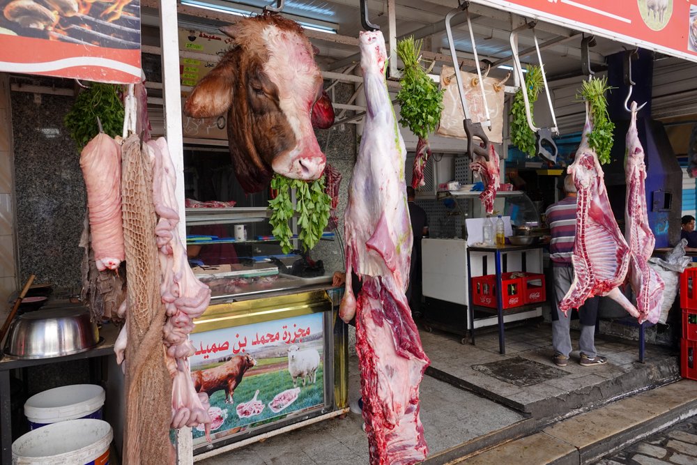
We didn’t know very much about these three countries which is why we went there. It was an educational trip for us but also lots of fun. We enjoyed lots of excellent food, the Mediterranean Sea, the Sahara Desert, the Atlas Mountains, some incredible mosques, Tataouine, Tozeur, seeing Star Wars and Indiana Jones filming locations, and travelling by camel, horse-drawn carriages, jeeps in the Sahara, a cable car, along with plenty of bus and plane time. People were friendly enough, especially if we were in the markets.

     I’ve attached some photos from each country to give you a glimpse into our trip:

North Africa has more Roman ruins than anywhere else in the world, and we visited a handful of them including Djemila, Algeria

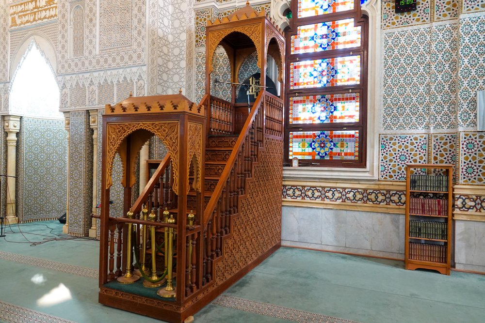
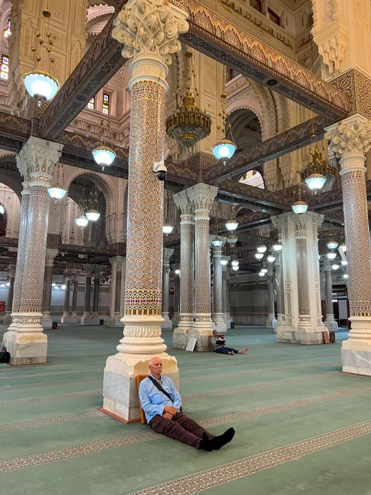
Mosques were a frequent visit including the Mosque of Emir Abdelkader in Constantine, Algeria

A trip into the Sahara Desert wouldn’t be complete without going for a camel ride

Remarkably, we had several Obi-wan Kenobi sightings near Tataouine, Tunisia at Star Wars filming locations

We enjoyed numerous home-cooked meals including this one in the Atlas Mountains of Morocco

We even had the joyous opportunity to walk across a real bridge that was straight out of an Indiana Jones movie, in Morocco

Algiers, Algeria

We started our North Africa trip in Algeria. Algiers, the capital, was our first stop. Algeria, like its neighbors around the Mediterranean, has known many empires and dynasties over the years. These include the ancient Numidians, the Phoenicians, Carthaginians, Romans, Vandals, Byzantines, many different Arab and Berber dynasties, Spaniards, Ottoman Turks, and finally, the French. Of course, there were smaller entities operating here as well, such as the Barbary pirates in the 1500’s. All these prior dynasties give a hint as to why Algeria has seven UNESCO world heritage sites. Then, the French were here for 132 years, from 1830 until 1962 and it took eight years of fighting to get the French out of Algeria and for Algeria to achieve independence. It surprised me to learn that the fighting and independence happened in my lifetime.

     Algeria is the largest country in Africa and the tenth largest in the world. Yet over 90 percent of the people in Algeria live on only 12 percent of the land since the Sahara Desert covers 90 percent of Algeria. Most people live along the Mediterranean coastal zone. Yet despite a small portion of Algeria being arable land, they produce lots of crops. They grow wheat, citrus crops, dates, figs, cherries, grapes, and they even make wine. But their biggest exports are fossil fuels, including petroleum, natural gas, and ammonia. Nearly all Algerians are Muslim and predominantly Sunni.

     Algiers is a big town of about five and a half million people. It extends along the bay for miles but it’s more known for having a High City and a Low City. The city goes from the minimal coastal flatlands up high into the hills. It’s also a wild mix of the very modern and the very ancient, meaning many centuries ancient. I can’t say that I loved our time in Algiers but then I’m not really a big-city guy. At any rate, this post is from Algiers with just a few highlights.

The first photo is one that I took from our hotel room. It gives an idea of Algiers. But though we were only a couple of blocks from the Mediterranean, it seemed impossible to walk there. The way was blocked by steep gullies, highways, and every sort of blockade to pedestrians. Algiers is hilly and curvy, and was often disrupted over the centuries city.

The next photo is Vicky and our group sitting in a café in the low city area. It looks like we could be in France in a StreetSide café.

Looking up from the low city, you can see the high city with both old and new buildings.

This is the old Kasbah in the High City. It’s a UNESCO world heritage site. We walked through these buildings plus many other narrow, winding streets. We visited shops, and tried some fresh bread and some pizza with Soumia, our guide.

This was on an excursion along the coast of Algiers. It’s beautiful along the coast but most buildings and houses are in pretty bad shape and need lots of reconstruction, which I’m sure will get done, considering such a great location.

The next photo is a street in the Low City. I was standing in front of the Ketchaoua Mosque which is at the foot of the Kasbah. It was an interesting street to navigate.

This photo is just to give an idea about many of the streets in the Kasbah in the High City. The streets were often steep and narrow.

Our guide, Soumia, is drinking water from one of the few remaining street water fountains for people to get their water. She took a drink but we passed on the opportunity.

Doors were a big deal in north Africa. I took a lot of door photos but most were wood while this one was metal.

The last photo was the Martyrs’ Memorial and museum. It’s in the shape of three palm leaves, sheltering the eternal flame. The memorial commemorates the Algerian War for independence from the French. It was a brutal conflict and visiting the memorial and museum was both highly informative and highly depressing.

Algiers, Home-hosted Lunch

One of the things we really like about our travel company, OAT (Overseas Adventure Travel) is that they arrange for home-hosted meals, both lunches and dinners. This trip had more home-hosted meals than most of our OAT trips and these meals were some of the real highlights of the trip. It’s a chance to go inside someone’s home, meet and talk to them, and get a good, local, homemade meal.

     This lunch in Algiers was inside the Kasbah in the High City in a 10th century home. The family that hosted us has lived there for well over one-hundred years and it is a multi-generational family residence.

The first photo is where our bus stopped to let us off for this lunch. At that point, it looked a little dodgy to me.

We eventually arrived at the street in the second photo and the last door on the right was to our home visit.

The home was multi-story and hard to capture in photos. This will just give an idea of what it was like. I found it very impressive for being around since the 10th century.

This is the daughter (our hostess and server) and her mom (the cook) in their kitchen. To give you an idea, I was standing with my back against the back wall of the kitchen to take this photo. It was a very small kitchen.

Lunch was on the second floor (I think). Then, we went up one or two floors to get to the roof. They really have a great view plus room for plants and pets to roam.

We had tea and dessert up on the roof. (this photo is just 180 degrees from the prior photo)

They had multiple pets. There are two in the last photo and they seemed to get along just fine. They also had birds.

Djemila Roman Ruins

     We must have visited five different sites of Roman ruins in Algeria and Tunisia. We were told that north Africa has the best Roman ruins of anywhere in the world. I’m sure that is because other countries, like Italy, built right over the older Roman towns and villages. In north Africa, they often went unoccupied and many are still the same way today.

    The Roman ruins at Djemila are considered one of the best preserved in all of north Africa. Djemila is one of three Roman ruins sites in Algeria that are UNESCO world heritage sites. It was founded in the 1st century AD as a Roman military garrison and was named Cuicul. It sits on a high plateau at an altitude of 3,000 feet and overlooks two rivers. It’s also cooler than most of northern Algeria.

     The Djemila site started as a military garrison but the town later developed into a trading center that flourished in the 2nd and 3rd centuries when more than 20,000 people lived here. Christianity reached Cuicul in the 4th century and the town expanded further. But then slowly, after the fall of the Roman Empire around the 5th and 6th centuries and the Arabic invasion arrived in this area of Africa, Cuicul was abandoned. I found it interesting that the Arabs renamed Cuicul to Djemila (which means Beautiful in Arabic) but they never reoccupied the town.

The first photo was an overview photo. This only represents a small portion of the site but you can see it’s extensive.

The next photo is the Temple of Gens Septimia.

I believe that the next photo is the main road in Djemila.

The Roman theater is in the fourth photo and we were told that it could hold 3,000 people.

The Djemila museum had many of the mosaic floors from the town. The mosaics have been put up on walls in the museum for display and protection purposes. The museum also has statues and other artifacts but the mosaics were the most impressive displays. The floors in Djemila were truly beautiful back in the day.

Palace of Ahmed Bey

One of our first visits in Constantine was the Palace of Ahmed Bey. It’s an Ottoman era building that started out as his mother’s home and then got greatly expanded. The palace was built over ten years, from 1825 to 1835. Ahmed Bey utilized a Genovese engineer and two well known artists for the architectural design. But only two years after Bey moved in, the French chased him out and made his palace into their headquarters. 

     The palace consists of three suites connected by hallways which have arches supported by 266 marble columns. It has two marble fountains, three courtyards, 540 cedar wood doors, sculptures, decorations, paintings depicting Ahmed Bey’s travels, and marble and tile everywhere including both Tunisian and French tiles. The courtyards have orange trees, palm trees, cedar trees, and more plants.

The first photo is to try and give a sense of the structure and size of one of the three suites. The gardens were also very nice.

The hallways connecting the suites and other areas were very extensive and beautiful in their own right. The columns, fountains, and floors were all marble.

This is the room where Ahmed Bey would conduct his business. In particular, notice the tiles and the men’s dress.

This is another view of the hallway but notice the wall tiles and the extensive paintings that were up above the tiles. Some 6,500 feet of walls and ceilings were covered with paintings, now mostly very deteriorated but still visible.

The last photo is the Harem. It was obviously very extensive. The fountain would have been working and the pool would have been filled with water back then. It was a bit of a challenge for me when we visited here as it was me and eight women in our group. I kept on the quiet side.

Constantine, the City of Bridges

After two days in Algiers, we drove five hours to Constantine. Our guide said it’s known as the City of Bridges and as the Arab capital of culture. The Rhumel River gorge has evidence of prehistoric settlement and Constantine has been well settled since at least the 3rd century BC. The main reason for this is probably that it’s a natural fortress. The city occupies a rocky plateau that is surrounded, except at the southwest, by a steep and deep gorge that is not subject to assault. The gorge is probably between 500 and 1,000 feet below the city and also very wide in most places.  

     Since Constantine is known as the City of Bridges, I thought I would start off our visit here with some of the bridges that we saw and that we crossed during our stay here. These photos will also let you see the lay of the land around Constantine.

     These are photos of a few of the bridges of Constantine. It has lots of bridges. 

The first bridge photo was taken from our hotel room. It’s the Sidi Rached bridge or viaduct which crosses the Rhumel gorges. It was built between 1908 and 1912. It’s over 1,500 feet long and has 27 arches. The tallest arch is 230 feet high.

The next bridge photo was also taken from our hotel room. It’s just to the right of the first bridge photo. It’s the Salah Bey Bridge and is the newest bridge in Constantine. It opened in 2014 and is 2,460 feet long and over 800 feet high.

This is the Sidi M’Cid Bridge, also known as the Gantaret El Hibal bridge. It’s the most famous bridge in Constantine. It opened in 1912 and for the next 17 years, it was the highest bridge in the world at 574 feet. We walked across this bridge though it also has vehicle traffic. We walked across it again the next night when it was colorfully lighted.

This is the El Kantara Bridge, also spanning the Rhumel river and gorge.

The last photo is the Mellah-Slimane suspension footbridge. It’s 410 feet long, 360 feet high, and eight feet wide. It opened in 1925. We walked across this bridge heading for Old Town and some lunch. Our restaurant was just to the upper right of the end of the bridge.

Ighacssen Restaurant Lunch

     We crossed the Mellah-Slimane walking bridge into Old Town Constantine and had lunch at the Ighacssen Restaurant. It’s hanging on the side of the cliff just to the upper right of the bridge. It even has deck seating hanging from the edge of the cliff. We ate our lunch inside where it was a cave-like atmosphere. Our lunch here was really great, and one of the best meals on the trip.

Our first course was soup and bourak. Bourak is meat-filled pastry with parsley, cheese, and spices. Our local guide said that bourak is traditionally the food that people eat to break their fast after Ramadan. Both soup and bourak were excellent.

The second course was salad and rolls, which were really more like puffed bread.

Our main course was ‘tangia’. Tangia is actually the cooking vessel but also the name given to the dish inside. It usually involves slow cooking, ideally over charcoal or a wood fire. But I must say that the presentation was excellent as you can see. Inside was meatballs, chicken, and vegetables and it was all really good.

As you can see, the tangia was a popular order for our group.

Dessert was almond treats in a sweet sauce with fresh fruit and mint tea.

Emir Abdelkader Mosque

The Mosque of Emir Abdelkader was our last visit of the afternoon on this day in Constantine. It’s one of the most prominent monuments in Algeria and one of the most important mosques in the Muslim world. Emir Abdelkader was an Algerian religious and military leader who led a struggle against the French colonial invasion in the early 19th century. He was an Islamic scholar who found himself leading a military campaign. He built up a collection of tribesmen and for many years successfully held out against one of the most advanced armies in Europe.

     This mosque is an architectural masterpiece. It’s built of marbles and granite with lots of tile, stained glass, and wood carvings. It has two minarets that are 351 feet tall and a dome that is 210 feet high. The idea for building this mosque started in 1968 with a goal of accommodating 10,000 worshippers. It started as a simple mosque but the country’s president took a keen interest and the project grew. It became an incredibly beautiful structure, an impressive mosque, plus an Islamic University. It can now hold perhaps more than 15,000 worshippers in its two large prayer rooms, one for men and one for women.

I had a long, hot walk to get the first photo. My only disappointment with this mosque was that the fountains and water features were empty due to their drought. Otherwise, this photo would bear a resemblance to the Taj Mahal in India.

The next photo is much closer but I still had to stand quite a distance from the mosque to get it all in the photo.

The third photo is the men’s prayer room. This photo might include 30 or 35 percent of the room.

I included this photo to give a glimpse of the details of the marble, granite, woodwork, stained glass, tile, and lattice work.

I will confess to feeling overwhelmed and humbled while visiting this mosque. We were almost the only people on the men’s side and there were a few more women on their side. The whole place was magnificent but near the end, I had to copy a couple of locals and sit down and just be there.

Algeria Miscellaneous

This post will be my last from Algeria. It’s going to be a miscellaneous post of a few things that I’ve left out. We enjoyed our week in Algeria and our many visits and adventures. After this, it’s on to Tunisia.

The first photo is in the Kasbah in the High City. This was the operation for picking up garbage. It was very low tech.

The next photo is inside one of the very old palaces in the Kasbah in Algiers that we visited. From the outside, one might think they were entering a pathetic old building full of rubble, but that was hardly the case. Each palace was a pleasant surprise to see and at one time must have been magnificent.

Vicky is bargaining for bracelets in the third photo. This guy was a tough vendor. He would go from person to person, seemingly never finishing his bargaining with each one. Then he would go back through everyone again and again before anyone had a settled transaction. Vicky managed to buy two bracelets of ancient Berber designs.

Driving in Algeria was always a challenge. Around the next corner could be sheep, goats, cows, or horses.

The last photo was at the Botanical Garden of Hamma in Algiers. We were back in Algiers to fly to Tunisia. This is a very large, multi-use garden. It has 79 acres of botanical gardens, 94 acres of gardens, and 49 acres of arboretum. Its size and usage has changed over the years since it was established in 1832. According to our guide, one Banyan tree was the main tree that Johnny Weissmuller used to swing from in the movie ‘Tarzan the Ape Man,” in 1932. 

Welcome to Tunis, Tunisia

     The main part of our trip to North Africa was to Tunisia. We started our time in Tunisia in Tunis, the capital. Tunisia experienced most of the same empires and dynasties as Algeria. The final occupant was also the French. In the case of the French, they invaded Tunisia in 1881, secured the country, and then signed a “treaty of protection.” So Tunisia was a French protectorate, not really part of France, like Algeria. The French protectorate lasted until Tunisian independence in 1956, so for 75 years. Again, like Algeria, Tunisia gained their independence in my lifetime.

     Tunisia is the most northern country in Africa and also on the Mediterranean Sea. Most people live along the Mediterranean coastal zone. Tunisia is a little bigger than the state of Georgia. It is mountainous in the north and extends into the Sahara Desert in the south. The official language is Arabic but most people also speak French. Nearly all Tunisians are Muslim. It also has a Mediterranean climate with mild, rainy winters and hot, dry summers. We saw lots of agriculture along the coast and some of it reminded me of Salinas, near us in California. They grow primarily cereal crops and olives for olive oil. We also saw dairy, animals, artichokes, tomatoes, peppers, almonds, apricots, pistachios, cactus, and dates. We even drank some Tunisian wines.

     Tunis is the capital of Tunisia and a town of about three million people. It extends along the coastal plain and the hills that surround it. The core of Tunis is its ancient medina, a world heritage site. We noticed that Tunisians called the old core city the medina, while Algerians called it the Kasbah. I’m not sure why the difference. Tunis is also a wild mix of the very ancient, colonial-era buildings, and modern structures. I can’t say that I loved our time in Tunis either but again, I’m not a big-city guy. Also, much of our time in Tunis was actually spent visiting the surrounding area, which I found more interesting.

The first photo is one that I took on our first walk around Tunis. It gives an idea of the architecture that we saw in Tunis. I’m guessing that this is Ottoman-era architecture.

The next photo is just more architecture in Tunis that I found interesting.

The third photo is the Hotel Royal Victoria. The sign is just to the left of the door, and you can see Vicky standing there pointing up at the sign. This world has more places named “Victoria” than any other name on earth.

Near the end of this day, our guide quietly took us into several old former madrassas, which were all closed in 1957. They had been Islamic schools but now are used for some type of training. In this one, a guy came and told our guide that we (the Americans) should not be there. He said that if the Imam walked in, he would be mad at our guide for letting us inside. Our guide told the guy that “we must educate the infidels,” (wink, wink to us) and the guy shut up and went away. 

This was at a restaurant in the medina in Tunis. Vicky saw an item listed on the menu that said, “brick.” She couldn’t resist and she ordered a brick. You can see it on her plate. It was a crepe with eggs and vegetables, then refried. She said it was very good. I had couscous with fresh fish and it was excellent.

Much of our time in Tunis was spent in the ‘souks.’ A souk is a set of shops and stores located in the medina. It can be an area of several streets and alleys. Most of the souks were built back in the 13th century. It’s easier if you just think about a souk as a market.

This is just one juncture in one souk. You can see that the area is old, crowded, and goes off in many directions. It would be very easy to get lost wandering around the souk.

One of my favorite sub-markets here was the fish market. They really had it all, including many fish that I’ve not seen elsewhere. This photo has some squid, shrimp, and other things, and they really had it all.

The next photo is also in the fish market and I don’t believe that I’ve seen this fish before in any market.

Tunisia is one of the world’s largest olive producers, so we saw olives for sale everywhere and were served them for most meals: breakfast, lunch, and dinner. Fortunately for me, I love olives. 

The vendor in this store insisted that I try on a fez. I think I actually look pretty good in a fez, but I didn’t buy it.

Darel Jeld Restaurant

This was our welcome to Tunisia dinner. It was at the Darel Jeld Restaurant in the medina in Tunis. The restaurant was formerly an 18th century sultan’s palace. It was a really nice place and probably the best meal that we had in north Africa.

The first photo is in the downstairs area. We ate upstairs in a private room. When we left, every table was full of people. We had arrived early.

The next photo is the salad portion of our dinner. Each group of four people was served three salad plates. You can see these in the lowest three plates. The upper left plate was a seafood platter with shrimp, calamari (the best I’ve ever eaten), mussels, etc. The second plate was tomatoes, mozzarella cheese, olives, etc. The third plate was tuna, eggs, olives, peppers, etc. Each salad was delicious and I could have made a meal out of any of them.

I’m relaxing and enjoying some Tunisian wine in the third photo. Notice the sultan’s tile on the wall behind me. This was my main dish which was beef and vegetables, along with fresh baked bread.

Vicky’s main dish is in the fourth photo. She had beef, couscous, and vegetables. She said it was very good.

The last photo was our dessert tray, plus we had mint tea. Then when we were finished, they came around and sprinkled our hands with orange water. It was an excellent meal!

Berber Nomads

On this day, we drove out of Tunis going east. About ten miles out of town, we stopped right along the highway. This was an unscheduled stop that our guide decided would be worthwhile. It was. A group of Berber nomads were camped right next to the highway. The Berbers, self-named Amazigh, are the indigenous inhabitants of north Africa. They have lived there since perhaps 3,000 BC. They are still scattered in small communities across Algeria, Tunisia, Morocco, and the rest of north Africa.

     This family had eight or nine members. Their camp had one tent, camels, dogs, and a few other things. They were tending two herds of sheep that are owned by other people. They said that they live here for six months and then move to another location for six months. They tend the herds of sheep for a season and then receive a portion of the sheep herd for their work raising the sheep.

The first photo shows some of the nomad family plus one of the sheep herds, and part of their camp.

The second shows a couple more family members, the other herd of sheep, and some of their camels.

They had one tent which everyone shared. I asked her why the dirt was so high under the tent and she said it was to keep them from getting wet in a big rainstorm. Also notice the hard ground and rocks. This woman seemed to be in charge of the family and was our main source of information.

A car stopped on the highway and asked the nomads for some camel milk. One of the camels was nursing its baby and the nomad woman pulled the baby camel off and milked the camel’s milk into two bottles and then sold them to the people.

The camels eat cactus leaves as you can see in the last photo. That was all the food for the camels that I could see.

     Some people in our group seemed upset about this nomad family since they have nearly no possessions. They gave them some money to help them out. I won’t argue that by most standards, these nomads are poor. But, they are following in the footsteps of thousands of years of Berber nomadic history, and they seemed to be incredibly happy people.

Majaz al Bab

     We continued driving east from Tunis until mid-morning when we arrived in the small town of Majaz al Bab. Our guide called it a small town with a huge history. Ancient Carthage once ruled it. During the Punic Wars, Hannibal said that whoever has Majaz al Bab had the key to the door and is the master of all Tunisia. During World War II, this was where the Allied forces and the Axis forces first collided in the fight over north Africa. There is a Commonwealth War Grave site here dedicated to soldiers who died in two operations and it has thousands of graves.

     Our main reason for stopping in Majaz al Bab was to meet a local family and spend the middle of the day with them, including lunch in their home. They have a small 13-acre farm with 1,800 pomegranate trees, 600 Tunisian olive trees, and 600 Spanish olive trees. The couple have three sons and two of them were home when we visited them.

The first photo is Souad and Magid Wertani, in their home. It’s a modern home with modern conveniences.

They took us to their local market to buy some of the items we needed to make lunch. We didn’t purchase any meat but the butcher shop was one that I found most interesting, due to its displays.

We helped Souad make lunch which included pounding out the flatbread dough and baking it.

One of their sons was outside at the BBQ cooking up peppers, tomatoes, and zucchini.

The last photo was in their pomegranate orchard. To say the least, I was envious!

Djerba Island neighborhood

     After four nights in Tunis, we had an early morning flight to our next stop which was Djerba Island. Our first stop on our bus ride was to the Hara Sghira neighborhood. Our guide said that this neighborhood was mostly Jewish and some Christians. I can tell you this, it was an incredibly artistic neighborhood.   

     It’s my understanding that in 2014, they invited 150 street artists from around the world to create 250 Murals throughout the neighborhood. That resulted in what might be called an open-air museum. In addition to the colorful and creative murals, it has many white walls, sprawling bougainvillea, and many colorful doors to go with them. It was a fun stop for us.

     While here, we stopped at the La Placette Café for some coffee and sweats. 

The neighborhood was largely based on a blue and white color scheme. This is just one of the streets we walked.

The next two photos will show more of the murals painted on the walls.

The red tree on the left was one of my favorite murals.

Vicky couldn’t help herself. Oh alright, I actually asked her to stand there for my photo. Good idea, huh? And yes, her left antenna needs a little work.

There was a wide variety of murals, some of which I found both curious and interesting.

Houmt Pottery Maker

We are in Houmt, the main town on Djerba Island, Tunisia. In the case of this post, we are on the edge of town somewhere to meet a local potter. We went inside his small, cave-like shop. It’s a small-scale operation. I didn’t learn this but I’m guessing that this particular potter has been doing this for a very long time. Pottery making is very popular in Houmt as the souk (market) was full of pottery of all sorts. 

The first photo is our group entering his small pottery shop.

The next photo was the potter just starting to create something for us. We had no idea what he was making.

In the next photo, he is adding the fancy touches to his substantial vase that he created.

He is showing us his finished product in the fourth photo and it only took him a few minutes to complete it.

The last photo is one of his two kilns, just outside of his shop. You can notice the dead palm fronds on the top of the rocks and they are what he uses to heat up his kilns and cure his pottery. 

Chenini, Tataouine

     This day we drove south into the Tataouine district in southern Tunisia. Driving there, we passed nothing but olive trees as far as the eye could see for over an hour of driving. Berbers, the indigenous north Africans, live in Tataouine along with some Arabs. Berbers live in caves in the rocks or in underground caves. They sometimes make hand-made cave dwellings. They live on the edge of the Sahara Desert. At one point during our drive there, our guide said that we were about 30 miles from the Libyan border and our guide said that the Libyan border was open, though I’m not sure why he told us that. 

     Our first stop in Tataouine was the small Berber village of Chenini. The original village is located on a hilltop but there is a more modern village at the bottom of the hill. Chenini was a fortified granary or grain storage facility. It was located on the hilltop to help the Berbers protect it from raiding parties. The oldest structures date back to the 12th century. Some of the buildings are still used to store grain for the modern villagers living below in the valley. There are even a few stores up there. We had a local Berber guide who told us that only the highest buildings were for storing grain and that people lived in the lower buildings.

     You might recognize the name Tataouine if you’re a Star Wars fan. Of course, George Lucas changed it to Tatooine for his film series. Many scenes from the Star Wars film series were filmed here in this area. Tatooine was Luke Skywalker’s home planet on the outer rim of the galaxy in the Tatoo system and one of the three moons of Tatooine was named Chenini.

This first photo is looking up from the modern village below. Old Chenini was built between two hilltop ridges and was quite extensive. This is only a small portion of it.

The second photo is to the right of the first photo and the two together make up less than half of the ancient village.

The third photo is on our hike up to the top. You can see doors to some of the housing lower down the hill.

Vicky was going inside one of the ancient houses to check it out.

The last photo is the inside of one of the houses. There was not much to see on the insides.

This is another view of housing but higher up and closer to the grain storage area. Old Chenini was steep and rocky, so those people had to be very determined to live up there and protect their grain.

The next photo view was prominent, we were told, in Star Wars, especially the rock outcropping on the right. This photo was taken from the top of the granary area, looking out the back side of Chenini. 

In the next photo, all the prior photos are above Vicky to the left. What is behind Vicky is the other half of old Chenini, which is similar to where we walked. This gives a better idea of the total size of the ancient village.

The next photo gives a better idea of the housing and roads in old Chenini but they have clearly done some restoration work. 

After hiking to the top of the old village, we stopped for a cold drink. While sitting along a walkway, a group of women passed by us. They were all Tunisian school teachers. They told us that they are visiting their country to learn more about it so they can be better teachers. They were a fun group and very engaging with us.

Modern Berber Mountain House

     We had lunch near Chenini but in a modern Berber house. The family welcomed us into their home which was great to see. They were in the kitchen right next to us cooking so I got to see them prepare the food. It was all hot, fresh, and done very simply.

The first photo is the woman of the house greeting us and welcoming us into her home. Our guide is on the right and the front door is right behind him.

The second photo is part of the interior courtyard. You can see that it fits right in with the mountain which is the Berber style. We ate lunch in the room on the right.

This is the interior room where we ate lunch. The window opens to another part of the interior courtyard.

Our meal started out with salad, bread, and fritters. All were very good. Our next course was barley soup. (not pictured)

The last photo was the main course which was goat on pasta. It was very good too.  

Ksar Ouled Sotane

     This was the afternoon of the day that we visited Chenini. This is Ksar Ouled Sotane, another fortified storehouse for grains and also in the Tataouine district. It was also constructed by Berber people on a hilltop to help protect it from raiding parties in previous centuries. My understanding is that this was built in the 15th century.

     An important point is that these buildings have survived not only raiders but a very hot climate. The walls are thick so that even in the Sahara Desert heat, they stayed cool enough to protect the grain. This granary featured multi-story vaulted granary cellars, spread out over two courtyards. This visit was one of the trip highlights for me. 

     These are photos from Ksar Ouled Sotane.

The first photo is one corner of one of the two courtyards in Ksar Ouled Sotane. The palm trees were in the middle of the courtyard.

The second photo is a closer view of some of the buildings.

The third photo was taken near the second photo but looking back. This is all one of the two courtyards.

Vicky is testing the 15th century construction. She found out that it’s still very stable. 

The next photo is just to show that they hoisted the grain up by way of ropes and pulleys or some such method. The board or tree branch at the top was used for hauling up the grain.

Ksar Ouled Sotane impressed George Lucas when he visited here. This was another key discovery in Tataouine that had a big impact on the Star Wars movie series. We were told that scenes in four of the six Star Wars films were filmed here. For instance, we were told that Ksar Ouled was the slave quarters where Anakin and his mother lived in the ‘Phantom Menace.’ And again, George Lucas also took names from here for his movies.

We were surprised and delighted to have an Obi-Wan Kenobi sighting while visiting here. He looks bigger than in the movies but this is real life.

The second photo is the inside of one of the grain storage rooms. There’s not much to the insides.

In another Obi-Wan sighting, there seems to be a disturbance in the Force, based on the expression on Obi-Wan’s face!

We did find two businesses open here including this guy selling coffee and his artworks.

The last photo is just a close-up of some of the buildings. I found this place magical.


Luke Skywalker's House

This post of from the small Berber town of Matmata, still in the Tataouine district. Many of the residents here live in traditional troglodyte houses. Troglodyte houses are made one of two ways. First, many are made by digging a large pit in the ground that’s left open and around the pit’s perimeter, artificial caves are dug into the mountain to be used as rooms. Sometimes, multiple pits are dug and then connected by tunnels or passageways. These houses are usually two-stories deep with ramps, stairways, doors, and openings, but no windows. They tend to be dark and we had to be careful when walking inside them.

    One troglodyte house that we visited was the Hotel Sidi Idriss. It was originally a traditional Berber house. In Star Wars, this was Luke Skywalker’s desert homestead, appearing in at least two of the film series. Matmata was also the location for the Disco scene in the very first Star Wars movie. That was one of my all-time favorite movie scenes.

The first photo is to show the lay of the land and a traditional Berber troglodyte house from the ground above it.

Vicky is standing at the entrance ramp to the hotel. The ramp slowly goes down into the underground house. 

The interior courtyard is quite large with many doors, steps, and ramps around it. It also has quite a bit of leftover Star Wars memorabilia. 

I don’t know if this was the theoretical bar entrance for the scene in the movie but lots of Star Wars stuff here.

The last photo is to show that the house, now a hotel, is indeed two stories deep in the ground. As we walked through the hotel, we were always going up and down on ramps or stairs.

Lunch in Troglodyte House

I mentioned in the prior post that there are two types of traditional troglodyte houses. The first is by digging a pit in the ground. The second way is by digging into the side of a mountain and then creating the same format for the house. While still in Matmata, we visited a family in their home of this style and they served us our lunch. Our guide said that this family is a semi-nomadic Berber family. So evidently, they live part of the year in another location.

The first photo is the entrance to their home and the Berber couple are coming out to greet us. Their entrance door is under the fish but I never learned about the significance of the fish.

The second photo is the entrance to the house which is really like a cave entrance way, dug into the mountain.

The entrance cave led to their courtyard, just like the courtyard in the pit-dug troglodyte houses. On a side note, our guide told us that no troglodyte house in Tataouine ever had white paint around the doors or windows UNTIL George Lucas did it in Star Wars movies. Our guide called the white paint the “George Lucas effect.” We saw several houses like this in Matmata. We ate lunch in the room on the left in this photo.

This was where we ate lunch with our host starting to serve us.

This was one of the main dishes that we were served. It was basically eggs over tomatoes. The rest of our lunch was salad with eggs, fresh baked bread, vegetable stew, and sweets, pears, grapes, and tea for dessert.