Are you ready to go to Bhutan?

Our trip to Bhutan was a trip within a trip? Part of our 27 day trip to India included five days in Bhutan. Bhutan was a country that I knew very little about but I can tell you it was a real treat. I like going to countries that I know very little about. It becomes a discovery trip for me and that was Bhutan in a nutshell. It was one giant discovery and I enjoyed the entire time we spent there.

What other country can you just happen to run into the King two days in a row? What other country can you run into the Queen and have a genuine conversation where she is leading the conversation about where I am from and where have I been and have I enjoyed what I’ve seen and done. She was a lovely woman and it was a treat to meet her.

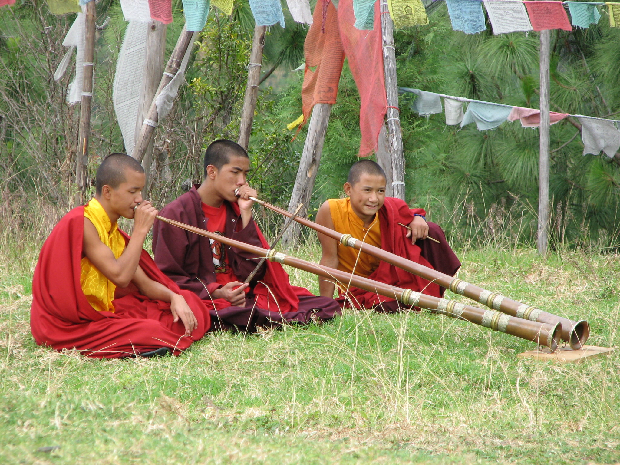
I’m going to post some photos but not my usual ‘highlight’ photos. I’m going to post some photos that will give you a little ‘flavor’ of the people and culture that we found.

The welcome sign below seemed very genuine in that most people were quite friendly to us. Many spoke to us and in particular the younger people. You will also notice the architecture and decoration of the sign. Those were consistent features in Bhutan.

IMG_6618.JPG

Bhutan is a mountainous country. We were always in the mountains and we often saw beautiful peaks as well. Here is the Himalayas where Bhutan meets Tibet.

IMG_6724.JPG

We tried all the food they put in front of us and lots of food that we had to stop and buy. This is beside the road and we tried their roasted corn. It was very tasty though I would say that they let their corn mature much more than I do before picking it.

IMG_6733.JPG

There is nothing wrong with short people but I will say that I’ve never been anywhere that I had to stoop over so far to look out the windows. The photo below was in one of our hotels.

IMG_6850.JPG

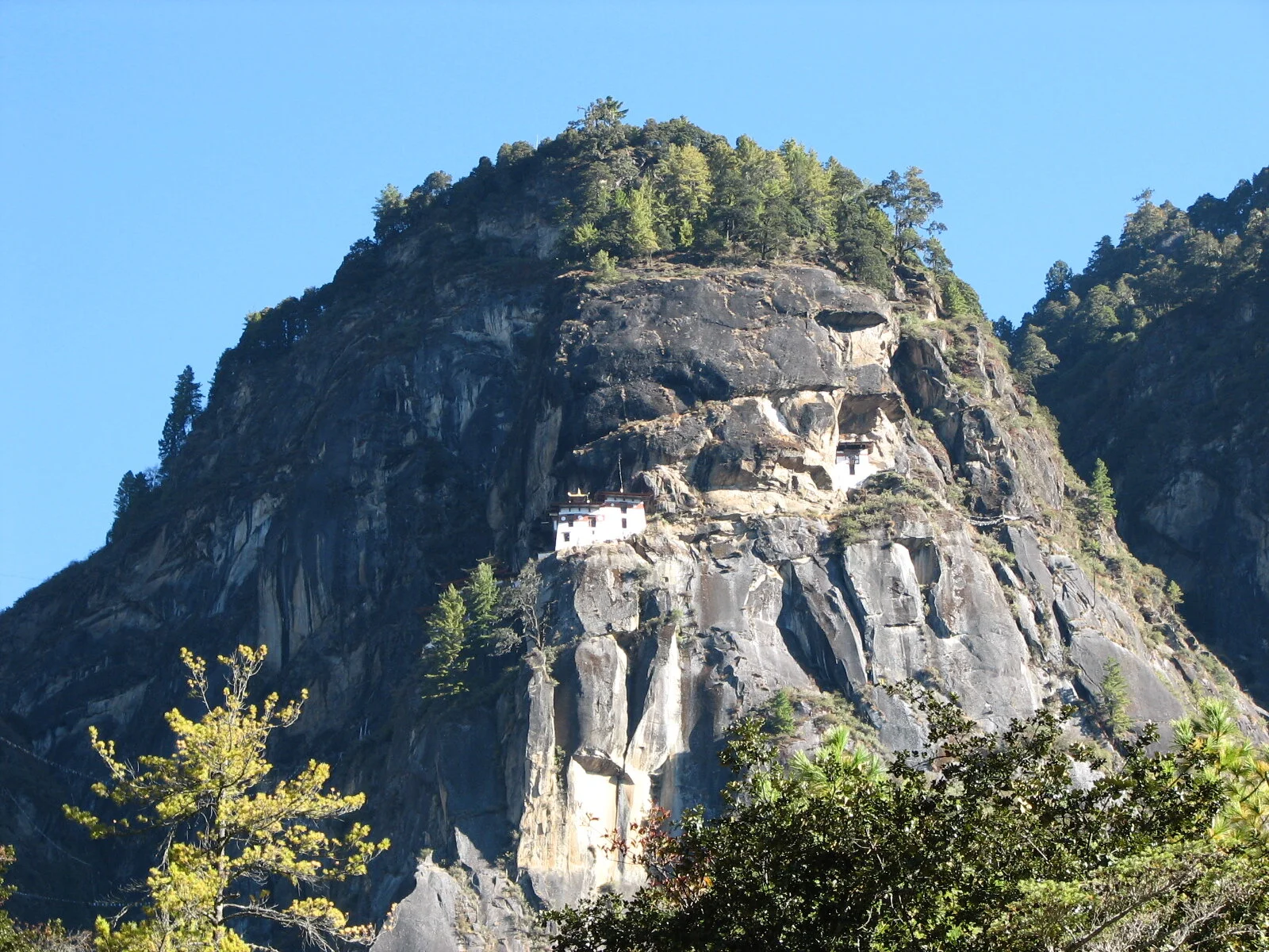
The highlight of our trip was our hike to the Tiger’s Nest monastery. You can also notice the prayer flags and these were scattered everywhere in Bhutan. It’s a Buddhist country and that was nice as well. Our hike up the mountain was one that we will never forget, along with meditating in such an auspicious place.

IMG_6828.JPG

Last but not least, we traveled with our good friends Ron and Patty Weber. You can see Patty below with Vicky. They have been our frequent travel companions and Bhutan was another great country for us to be able to enjoy with them. This was atop Dochula Pass.

IMG_3577.JPG

Flying into Paro, Bhutan

I don’t believe that I have ever started a trip by telling you about the flight, but our flight into Bhutan was a real adventure all by itself.  Our flight to Paro Bhutan started from Calcutta India.  It was a one hour flight.  Our guide in Calcutta said to try and get a window seat as we would spend about twenty minutes flying past the great Himalayan peaks including Mount Everest and Mount Kangchenjunga.  I managed a window seat, thanks to Vicky, and it was quite a show.  I’m not sure which peak is which but you can see the Himalayas in the first photo.  I took this from our plane during the flight.

IMG_6852.JPG

At some point during the flight, I noticed that we seemed to be getting rather close to the ground.  I could see that we were well below the mountain peaks and I could see the small villages and farms on the ground very clearly.  You can see what I mean by looking at the second photo.

IMG_6591.JPG

This was one of the bigger villages that we passed.  I didn’t know the elevation of Paro, but I knew that the Himalayan peaks in this area were in the 16,000 to 17,000 foot range.  Shortly after I took the second photo, I noticed that our plane took a hard right bank and seemed to be flying down a mountain canyon.  Shortly thereafter, our plane banked hard left, again going down the canyon.  This continued for several more banks and canyons.  At that point, I turned to Vicky and said, “I don’t want to alarm you, but I think our plane is going down”.  Vicky looked at me very calmly and said, “Why do you think that?”  I said, “Have we ever been on a commercial airliner that did sharp banks down canyons, let alone that we are in the Himalayas?”  We did about two more sharp banks, and then quite literally fell out of the sky and landed on the runway at the Paro Airport.

IMG_6594.JPG

We learned only later that Paro Bhutan airport is perhaps the most difficult airport to operate.  There are only eight pilots qualified to take off and land at Paro Bhutan.  They all work for Druk Airlines, our carrier, so I presume that one of the eight was piloting our plane.  Paro Bhutan is at an elevation of some 7,300 feet and again, the peaks around Paro are over 16,000 feet.  Paro Airport is also the only airport in Bhutan.  We landed safely, and gratefully, in Paro to start the first week of our trip.  We got in our bus to drive away from the airport.  The road out of the airport runs exactly parallel to the runway and is only about 100 yards from the runway.  In the last photo, you can see a photo I took from our bus.  It’s about the mid-point of the runway and it is looking at the direction that we flew into the airport.  The red and white sign is at the start (or end) of the runway.  The canyons you see in the upper left of the photo are the canyons that we banked our way through on our way down to the runway.  It’s also the direction that we flew back out of Bhutan.  What a start to the trip!

IMG_6595.JPG

As a sidelight, the road out of the airport was the ONLY straight road in Bhutan.

Welcome to Bhutan

Welcome to Bhutan.  Bhutan is a Himalayan country that really stands out amongst countries of the world.  Bhutan is the least urban, and most rural, country in the world.  It was the last country in the world to get television and the last country in the world to get the internet – both quite recently.  Bhutan has never been conquered by anyone and has never been occupied by anyone in its entire history.  It sits in the Himalayas between the mountain peaks separating it from Tibet and the malarial jungles of India.  It has only been an official ‘country’ for about 100 years.  Before that, it was just a place where the Bhutanese people lived.  Bhutan did not have a single road in their country until the 1960s, and they don’t have many roads today.  The people are rather small and were really quite friendly.  Many people would say hello to us and talk to us, especially the younger people.  Bhutan is a Buddhist country.  Many of the men in Bhutan shave their heads, so I really fit in quite nicely.

We were barely out of the airport and Paro itself when we made our first unscheduled stop.  Our guide saw a family threshing their rice and asked if we wanted to stop and get a closer look.  We did, of course, and just like that, we were into life in Bhutan.  Most people in Bhutan are farmers and they do most of their work by hand.  I don’t remember seeing any “real” tractors in Bhutan.  We did see what our guide called something like tractors, but they were actually a Japanese product that was the equivalent of a ‘drivable’ roto-tiller.  We did see a lot of those, both in fields and on the roads.

At any rate, these first photos are the family that we met threshing their rice.  Their house was just up the terraced hills to the right of the first photo. 

IMG_6596.JPG

In the second and third photos, you can see the outskirts of Paro in the background.  Mind you, there are lots of farms right ‘inside’ most towns.  After watching the rice threshing for awhile, our guide asked for ‘volunteers’.  Naturally, I sent in the ‘first string’ (see Vicky in third photo).

IMG_6598.JPG
IMG_6601.JPG

Eventually, I couldn’t help myself and had to give it a try as well.

IMG_6600.JPG

National Memorial Stupa (Choeten)

We visited the National Memorial Stupa (or Choeten) in Thimphu.  It was only built in 1974, by the mother of the third King of Bhutan.  A stupa is a sacred or spiritual monument.  It’s a Buddhist symbol of enlightenment.  Stupas are supposed to emanate blessings and peace.  We saw quite a few stupas in Bhutan, so I probably won’t show too many others.  You can see the memorial stupa in the first photo.  People go there to pray.  They walk around the stupa on the circular path, praying as they walk.  You can see some Bhutanese people doing this in the second and third photos.  I took three laps around myself and prayed for all of you at this stupa. We can always all use a few extra prayers.

IMG_6636.JPG
IMG_6637.JPG
IMG_6640.JPG

They also had ‘prayer wheels’ near the front gate of this stupa.  Prayer wheels are evidently each dedicated to a certain prayer, such as long life or peace or health.  People hold them and walk around them, spinning them with them as they go to send that prayer out into the universe.  You can see Vicky and another person at the prayer wheels in the next photo and a closer photo of a prayer wheel after that. These were particularly large prayer wheels. Most of the prayer wheels were much smaller.

IMG_6641.JPG
IMG_6633.JPG

I show these pictures and give my explanation because this is a common event in Bhutan and seems to be a real part of the fabric of life in Bhutan which is a Buddhist country.

Bhutan Construction

Now we are in Thimphu (pr. Tim Poo) which is the capital of Bhutan.  Thimphu is only about 33 miles from Paro where we landed at the airport.  Thimphu is the largest town in Bhutan but only has about two streets of around three or four blocks each that make it look like a town.  One of the things that I loved about Bhutan was the consistent architecture in the country.  Our guide said that recently, and only slowly, was this starting to change.  Taller buildings are being built and different designs are being used.  But the construction itself looked like many other countries that we have visited.  Scaffolding and construction support beams are all bamboo.  Most of the work is still being done by hand.  As you look at these photos, you might notice that the bamboo scaffolding is not always very perpendicular.  Some of the poles are at substantial angles to perpendicular. 

IMG_6620.JPG
IMG_6622.JPG

You can also see in the next two photos that there are four guys unloading bricks from a truck into the building. They are putting them in the building, by throwing one brick at a time like two guys playing catch with a baseball.

IMG_6623.JPG
IMG_6626.JPG

All of this seemed quite amusing to me until the thought occurred to me that I was on the fifth floor of a hotel that was no doubt built in the same manner and maybe even by the same people.  I chose not to dwell on it. I did still keep staring at those darn bamboo scaffolds though.

IMG_6624.JPG

Long Life Ceremony

Our next stop on this day was a small temple to observe a ceremony to give children a long life.  Our guide knew where this was being held and we went to see it.  They seemed to be pretty big on both tradition and ceremonies in Bhutan and we were told that this ceremony is an important one.  Our guide said that ‘life expectancy’ in Bhutan is something like 53 years, so I can see why this might be an important ceremony for children. I was a little surprised by the crowds as I had expected a smaller ceremony. You can see a couple of photos below from before the start of the ceremony. The ceremony was held in an interior courtyard area of the temple.

IMG_3484.JPG
IMG_6642.JPG

What we saw at the ceremony was mostly clowns dancing.  The clowns included one with a big red mask with a big red nose.  He also had a big red wooden penis in his hand most of the time and would stick in very embarrassing places on the other clowns and people in the audience.  I never caught the significance.  We saw masks like the big red nosed mask being sold in stores and also saw pictures in stores.  I think that the figures represent something like the reincarnations of Buddha.  I’m not sure that Buddha would approve.  The main clown was in the center of the first photo below, with his back to the camera.  If you look carefully, you can also see him in action in the third photo below as well.

IMG_6647.JPG
IMG_3489.JPG
IMG_6651.JPG

As we were leaving this ceremony, we passed the (4th) Queen of Bhutan.  (note: the 4th King of Bhutan had four wives, hence four queens)  She was very friendly and spoke to us for several minutes.  She asked several of us where we were from and how long we had been in Bhutan and how we liked it so far and how long we were staying in Bhutan.  Her guards asked us to not take any pictures of her, so we didn’t.  It was so odd to just run across the Queen at a simple ceremony in a small temple and to have a conversation with her.  I instantly liked her and became a fan.  I also understand she is on Facebook.

The Takin Preserve

We didn’t see very many non-farm animals in Bhutan.  But we did make a stop at The Takin Preserve.  The Takin is the national animal of Bhutan.  A Takin is a strange looking animal.  It looks a bit like it has the head of a goat stuck on the body of a cow.  You can see one in the first photo.

Takin are found from forested valleys to rocky, grass-covered alpine zones, at altitudes between 3,300 and 14,800 feet above sea level. The Mishmi takin occurs in eastern Arunachal Pradesh, while the Bhutan takin is in western Arunachal Pradesh. The Takin is a muscular animal with well developed fur.

IMG_6661.JPG

We also saw barking deer and stag deer at the Takin Preserve.  You can see a stag deer in the second photo.

IMG_6667.JPG

The third photo was taken up in the mountains when we were on a nature hike.  These monkeys are a real problem for the farmers as they raid the rice fields and eat both the rice and other crops and also destroy many of the plants.  The farmers have to keep a watch posted for them. 

IMG_6778.JPG

Darts

The Bhutanese love sports.  Archery is their national sport.  Other major sports include soccer and darts.  As we were driving this day, we saw a game of darts going on and pulled over to the side of the road and made another unscheduled stop.  The game is a bit like ‘lawn darts’ only they use really big wooden darts.  The length of the throw is 25 meters or about 82 feet.  They have two teams of players with darts and both teams have players at both ends of the field.

In the first photo, you can see the whole game field which was being played in an empty field.  Each team has five or six players at each end of the field.  The target is on a small block of wood or foam. 

IMG_6654.JPG

You can see in the second photo that they are right in town or at least in a populated area with a road right next to the open field.

IMG_3496.JPG

You can see a player giving the dart a heave in the third photo. It takes quite a throw to get the heavy wooden darts to fly the 82 feet. In this game, two company’s employees were competing against each other.  You might also notice the yellow sashes hanging off some of the player’s belts in various photos. The sashes are awarded when a player scores a point.  You can tell the better players as they have more sashes hanging off their belts.  Most of all, they all seemed to be having a great time and enjoying the game immensely.  Their clothing, by the way, is standard traditional Bhutanese men’s clothing which is what most Bhutanese men wore. 

IMG_6655.JPG

In the photo below you can see the target and a better close-up of the darts. That’s a small target for a throw of 82 feet.

IMG_6656.JPG

I believe that in the last photo, we are seeing some consternation over the scoring. I think that there is a dispute about who scored or how many points were scored.

IMG_6657.JPG

Tashichhodzong

This complex is called Tashichhodzong, but our guide referred to it as the “Bhutan White House”.  It houses the throne room of the King plus government offices plus the center of Bhutan’s monastic body with temples and monks, sometimes including the country’s central monk.  The complex was built in 1641 and rebuilt in 1962.  The name means “the fortress of the auspicious religion”.  In Bhutan, most important temples or palaces are also forts as they had to be defended to be maintained.  We did not get to visit the King’s throne or his offices.  We could only visit the monastic parts of the complex.  The Buddhist temples were fairly typical.  We went inside three different temples.  We always had to take our shoes off before entering the temples.  We also got to observe a special ceremony with the monks which involved quite a few musical instruments.  I’m not sure what the ceremony was about, but we were the only people in attendance besides those involved in the ceremony.  The stairs and the ladders going up into the temples were very steep, very old, and very creaky.  The alters were very grand with all the statues, colorful cloth, pictures of Buddha, ornate carvings, and the like.  There was also always plenty of incense burning.  It was interesting that this was perhaps the most important complex in the country and we were told that they had military personnel guarding the place, but security was really not very substantial.

The first picture shows the complex along the bottom of the photo.  I chose this photo because it shows the Tashichhodzong but also the area around it.  This is the most important complex in Bhutan and sits in the capital of Thimphu.  To look at it, however, it seems more like a large temple in a good size Himalayan village.

IMG_6670.JPG

The next photo is the entrance to the Tashichhodzong complex. This was where we saw the most security. If you look closely you will notice that the building is highly decorative. That was true of all the interior.

IMG_6677.JPG

The next photo shows several of the temples from the interior courtyard.  The following photo just shows a monk climbing the stairs into one of the temples.  You can see the sag and wear in the stairs.  From there, we climbed up several ladders to get to the upper stories.  The ladders were in similar shape to these stairs.  You can imagine what I was praying for when in these temples.

IMG_6680.JPG
IMG_6684.JPG

The last photo shows Vicky in front of another of the temples that we visited.

IMG_6685.JPG

Archery

Archery is the national sport of Bhutan.  We were driving along and we made another unscheduled stop when we spotted this archery contest.  Teams compete against each other.  From what we were told, the game goes on all day long and sometimes, games take days to finish.  The archers and their targets are 140 meters apart which is 460 feet.  It was very difficult for me to even follow the arrows.  In informal competitions like this one, they do not use compound bows, but just old fashioned straight bamboo bows.  Most villages have an archery range.  Bhutan has not had much success in the Olympics in archery, because the equipment and the style of play is very different.  Olympic archery sets the targets at 50 meters versus Bhutan’s 140 meters.

In the first photo, you can see the whole field of play.  I took it standing behind the team that was shooting.  You can see their target in the center of the photo.  It’s a small white board in front of the low green mound.

IMG_6689.JPG

In the second photo, I zoomed in on the team at the other end of play while they were shooting.  Archers also get awarded colorful scarves for shots that score points and they hang the scarves from their belts.

IMG_6688.JPG

In the third photo, you can see a couple of the players at our end as the arrows were coming in from the opposite end.  They would often stand dangerously close as the arrows were being shot.  They obviously had better eyesight and better quickness than I do, or they wouldn’t be standing where they are.

IMG_6687.JPG

Dochula Pass

On this day, we spent about three hours driving up and over 10,000 foot high Dochula Pass.  Our guide said that the Germans had done a study of the road and determined that it had a curve every 10 seconds.  It was a long ride.  But then again, Bhutan does not have any straight roads.

On top of the pass, there’s a “Glorious Victory” Park with 108 stupas called Drukwangyal – for the Dragon Victory from a military battle somewhere back in time. You can see some of the 108 stupas in the first photo. Some people were walking around the stupa park.

IMG_6714.JPG

On the top of the victory park is a large stupa which Vicky is standing next to in the next photo.  The Drukwangyal Temple is in the background.  Below the largest stupa are concentric circles of stupas around the mountain top.  You can see some of them in these photos but never all of them at once.

IMG_6716.JPG

We also experienced some wind on the top of Dochula Pass. One thing you can count on seeing in Bhutan is prayer flags and that is never more true than in a windy location.

IMG_3540.JPG

In the background of the next photo is Bhutan’s northern Himalayan border with Tibet.  The last photo is just down the road from the victory park.  At that point, our guide said that while it had been about two hours since we had visited a bathroom, it would be another 90 minutes until we reached another one.  At this stop, last photo, he suggested to the women that they find a tree to their liking.  The women looked a bit surprised, but of course, Vicky led the charge saying “How often do you get an opportunity to pee in the Himalayas?”  Vicky took this photo to celebrate the occasion: a bathroom with a view – and prayer flags flying nearby to boot.

IMG_6723.JPG
IMG_6715.JPG

Himalayan Farming

Bhutan is an agricultural country. Farming is their chief industry. The majority of people in Bhutan make their livelihood from agriculture. That is far more true for women in Bhutan. Bhutan does not, however, have very many large and flat valleys where the farming would be relatively easy. Most of Bhutan is mountainous. And these are the Himalayan Mountains so they are incredibly steep.

Farming in the Himalayas is somewhat of a challenge.  The Bhutanese, however, seem to have it well established.  I took the first photo to show the challenge of the mountains and how it must be terraced on the steep hillsides.  The second photo is the same area, just a much more zoomed in photo.

IMG_6730.JPG
IMG_6731.JPG

You also need to understand that I didn’t see much in the way of sophisticated farm equipment. For that matter, I didn’t see any earth-moving equipment but they moved a lot of earth to make those terraces. You can see a closer look at some other fields in the next photo and can notice the size and shape of the fields. There are two Bhutanese women harvesting rice by hand right in the center of the next photo and a close-up photo of them in the following photo.

IMG_6727.JPG
IMG_6732.JPG

The last photo is another farm and offers a good perspective on the fields shapes. The red on top of the house in the last photo is chili peppers being dried.  The overwhelming majority of houses in Bhutan have chili peppers on the roof being dried.  We were served chilies and cheese at almost every lunch and dinner and most dishes had chilies in them.

IMG_6728.JPG

Metshina

Our next visit was to the village of Metshina.  It was our first stop after driving over Dochula Pass.  Our main destination in Metshina was a temple built by the ‘Divine Madman’, the Lama Druka Kuenley.  Bhutanese people believe that women who visit this temple and receive a blessing will conceive a child.  For my part, I warned Vicky not to receive any blessings, and then I followed her around and stayed close to her – just to make sure.  I wasn’t taking any chances. 

You can see the temple in the distance in the first photo.  It’s on top of the low hill in the center of the photo.  The village of Metshina is a typical Bhutan village.  Their villages do not have roads.  The trails, like the one Vicky is standing near, are what people use to walk around their village.  These are rice fields in the photo.  The stacks of rice that you see are rice plants that have been harvested, but not threshed yet.  They stack it for the rice to dry but to not get ruined in the case of rain.  The farmers come back and thresh it when they have more time. You can see me standing next to a rice stack to give a size perspective. Those are big stacks of rice.

IMG_6734.JPG
IMG_3548.JPG

The next photo looks off to the right from the first two photos and you can see more of the valley, terracing, and crops. It was a productive looking farming area.

IMG_6738.JPG

Now we have arrived on top of the hill at the temple built by the “Divine Madman”. We heard the guys below before we saw them. I don’t know if they were doing something timely and important for the temple or if they were just practicing but it sounded good. (and I like those haircuts)

IMG_6742.JPG

In the next photo, also at the temple, some people were hanging new prayer flags.  You can see Vicky giving them a hand.  The flags have prayers written on them as you can see if you look closely.  Then when the wind blows, the prayers get launched into the universe.  They always put prayer flags in windy places, just for this purpose.

IMG_6744.JPG

The last photo for this post is the “Divine Madman’s” temple. It was not too busy but I didn’t get many photos after this as I was staying close to Vicky to prevent her from receiving a blessing. There were young women there, however, for just that purpose.

IMG_6741.JPG

Punakha Dzong

This is the Punakha Dzong.  A dzong (pron. Zong) is a fortress like structure that’s built in a defensible position, such as protected by rivers or on top of a mountain ridge, with massive walls and massive gates, and inside is a complex of courtyards, temples, administrative (government) offices, monks quarters and maybe a monastery.  Our guide called this place the Palace of Great Happiness.  He said Punakha is not Bhutan’s biggest dzong, but it is Bhutan’s most beautiful dzong.  It was built in 1637-1638.  It was built without any plans.  A dzong is built on the dream of a carpenter or a lama with dimensions based on spiritual inspiration.  Punakha is 600 feet long by 240 feet wide with a six story temple in the middle and with a gold domed tower.  Punakha sits at the confluence of the Pho Chhu and Mo Chhu Rivers. 

Punakha was the capital of Bhutan until 1955 and is still the winter home of Bhutan’s Central Monastic Body.  It houses some sacred relics and remains and was also the site of the coronation of the First King of Bhutan in 1907.  Perhaps the most amazing part of this whole area is that it has a tropical climate.  It’s warm here even in the winter.  They grow orange and papaya trees here along with lots of vegetables and red and white rice.  One other highlight of this place is that the rivers are teaming with Rainbow Trout.  I watched trout regularly jumping out of the river and I would guess that the largest of them were several pounds.  The Rainbow Trout were planted here by the British.

The first two photos were taken of the Dzong from the road across the river.

IMG_6750.JPG
IMG_6754.JPG

The next photo is the cantilever bridge that we walked across to access the dzong.  The bridge was originally built in the 17th century but has been destroyed by floods several times, and then rebuilt to its original form.  The following photo is a building next to the dzong that was built prior to the dzong.  I think this is a monk’s quarters and maybe a school.  I only saw monks entering and leaving this building.

IMG_6756.JPG
IMG_6767.JPG

The next photo is the main entrance to the dzong.  It was here that we were delayed in entering due to the arrival of the King of Bhutan.  He was here for the anniversary of his coronation.  He walked right past us without much fanfare.  He talked to some other tourists, but we didn’t get a chance to talk to him.  His staff asked us not to take photos, so we didn’t.  There are actually quite a few more stairs to get up into the dzong than what you see in the photo.  The stairs were also quite steep. 

IMG_6760.JPG

The next photo was interesting for several points.  First, you can see some of the intricate carving and painting which is on every wall, ceiling, post, and support beam.  The dzongs are actually quite colorful and huge amounts of work had to go into all the wood carving and painting.  We had just visited this temple and only exited a couple of minutes before I took this photo.  I had noticed dozens of glasses of water sitting on the alters inside the temple.  I had asked our guide what the glasses of water were for.  He said that it’s a tradition and that it’s water for Buddha.  Since we were here near the end of the visiting hours, the monks were cleaning up for the day.  Evidently, the water for Buddha can be tossed out into the courtyard at the end of the day.

IMG_6762.JPG

The last photo is simply a photo of the largest of the courtyards, to give you a sense of the size of the dzong.  I don’t know what offices are where within the dzong but monks were always coming and going from everywhere within the dzong.

IMG_6765.JPG


Bhutan Roads

This post will just be a few comments on Bhutanese roads.  Bhutan had no roads in their country until the 1960’s.  That means that I am older than all of Bhutan’s roads. Fascinating! According to our guide, the original roads built in the 1960’s were very narrow.  Our guide said that in the last few years, the country had gone back and widened their roads to about twice the width.  The first photo is the road that we took over 10,000 foot high Dochula Pass and back.  I took this photo from near the top of the pass from a restaurant where we ate lunch.  It will give you a sense of how wide the new and improved roads are in Bhutan. I am glad that we didn’t tour Bhutan until after they widened their roads.

IMG_6806.JPG

Our guide also told us that Bhutan does not have any straight roads. Considering that Bhutan is in the Himalayan Mountains, I suppose that’s not a surprise. The next photo shows a part of this same road.

IMG_3576.JPG

I don’t know what Bhutan did before they had roads, but I know what they do now.  Everyone and everything uses the roads.  You can see us passing a herd of cattle in our bus in the next photo.  I leaned out the window to take this photo.  If you look at the land off the side of the road, you can see why everyone is going to use the road.

IMG_6792.JPG

Bhutan is a steep mountainous country.  If you need to get anywhere, the road is the way to go.  We had to slow down or speed up to find the wide spot every time we passed any other vehicle, not to mention cattle, horses, mules, goats, sheep, dogs, pedestrians, etc. The next photo is a better example of why all the roads get used by everyone and everything. This is steep country.

IMG_6710.JPG

I couldn’t resist taking the last photo.  It was a road sign that we saw several times on our drives.  I’m guessing that it means IF you drive safely on the road, THEN you will make it home safely to have your tea. It wouldn’t be a bad idea to have some of these signs in California.

IMG_6790.JPG

National Archery Championships

We were nearing the end of this day and about to leave Thimphu to drive to Paro when we happened to pass the National Archery Championships, in progress.  The match had been going on all day and we were told that it would not finish by the evening and so would have to be continued tomorrow.  We watched the match for about thirty minutes.

I took the first photo standing about even with the near end archers who were currently doing the shooting.  You can see their target in the center of the photo at the other end of the archery field.  The national archery distance in Bhutan is 140 meters or about 460 feet.  In the national championship, they used compound bows rather than their regular bamboo bows.  One nice thing about Bhutan is that it was easy for me to take a photo over the crowd. You can see more of the crowd in the next photo.

IMG_6810.JPG
IMG_6808.JPG

If you had never seen Bhutanese archery, you wouldn’t know what you were in for.  If you look at the next photo, you will see an archer preparing to shoot his arrow.  Notice the eight colorfully dressed women standing right next to the archer.  They are cheerleaders.  Each archery team has a set of cheerleaders.  One set of cheerleaders stays at each end of the archery field.  They stand exceptionally close to the archers as they shoot their arrows.  In this case, the cheerleaders are the cheerleaders for the guy who is shooting the arrow.  They were swaying back and forth and gently chanting.  Our guide said they were saying things like “you are so handsome and good looking and you are so strong and you are one of the best archers in the world and very virile” and things like that.  You might also notice that the archer in the photo is very good, based on all the colored scarves on his belt, for points scored.

IMG_3591.JPG

Now look at the next two photos.  This archer is from the other team, not from this cheerleading team.  By the second photo, just as he was about to shoot his arrow, they were shouting and jumping and waving their scarves at him and saying things like “you are ugly and stupid and you have a boil on your nose and you are a terrible archer and you can’t hit anything, not to mention your manhood is questionable and your likelihood of fathering children is doubtful” and stuff like that. 

IMG_3587.JPG
IMG_3590.JPG

Hiking to the Tiger's Nest

Our hike to the Tiger’s Nest Monastery was an adventure all by itself. Our guide said that it was extremely difficult and dangerous to climb to the Tiger’s Nest before the fire in 1998.  He said that in the process of rebuilding it, they vastly improved the trail.  I was grateful for that.  The trail starts at around 8,500 feet and goes as high as 11,000 feet before going back down to the Tiger’s Nest at somewhat over 10,000 feet.  The guidebooks say the hike takes around four hours, but we did it in around three.  I suspect a great mountain hiker or a local could do it in an hour. We also stopped for tea at the Tea House on our way up, so that added some extra time.

The first photo was taken from low on the trail and I was in full zoom mode with my camera.  I was excited at the prospect of reaching the monastery but also wondering just how difficult the hike would be.

IMG_6816.JPG

The first leg of the hike was to reach the Café or Tea House.  It was about half way up.  Some people opted out of hiking the first leg in order to take a mule, as you can see in the second photo.  Others of us hiked the whole way, while remembering to duck for prayer flags.

532 Vickie Bosworth and Patty Weber.JPG
IMG_3605.JPG

I’m at the Tea House or Cafe in the next photo. That makes it about half the way up to the Tiger’s Nest. The Tiger’s Nest looked a long ways away for my being half way there. Everyone in our group except Vicky and I turned around and went back down at this point. I can’t say that I blame them. It was steep climbing.

IMG_3604.JPG

The next photo is a very nice photo of Vicky and me on the hike. We got another hiker to take the photo. But while it’s a nice photo of us, the Tiger’s Nest is hidden behind us in the photo. Oh well.

IMG_3620.JPG

We made many stops on our hike. Some stops were to rest from the elevation change. Other stops were to see some interesting places along the hike. Below is not a great photo but I’m hiking up to the Lion’s Cave which was formerly a meditation place. The steps up to the cave were extremely steep, narrow, and also very small. The Bhutanese must have extremely small feet compared to me.

IMG_3616.JPG

The Tiger's Nest

Our visit to the Tiger’s Nest Monastery or Taktshang Goemba was the highlight of our trip to Bhutan.  The Tiger’s Nest founding, if I understood correctly, was based on a 7th century fable or mythical story about a flight to a cave here on the side of the mountain.  The Tiger’s Nest was originally built in 1692.  There was a fire here in 1998 that destroyed it, but the government rebuilt it.  The Tiger’s Nest is in the mountains above the Paro Valley.  Paro is around 7,300 feet high.  The trail starts around 8,500 feet and the Tiger’s Nest is somewhat over 10,000 feet, but the trail to get there goes as high as around 11,000 feet. 

We found a monk who helped us enter the Tiger’s Nest. We already had our permit. We had to leave our camera’s, backpacks, hats, and everything else but our clothes at the entrance point. From there, it was a steep two-story flight of stairs to enter. We climbed directly up to the Tiger’s Nest itself. We entered the highest temple and paid our respects. I made a contribution to the temple for our safe journey. Then, Vicky and I found a veranda outside overlooking the Paro Valley and meditated.

Afterwards, we climbed up a tall ladder and into a hole in the rocks. This was the cave in the story about the origins of the Tiger’s Nest. The monastery has twelve temples and we visited five or six of them. We took our time and enjoyed every minute. The Tiger’s Nest had temple cats and temple dogs.

These photos were taken prior to entering the Tiger’s Nest monastery. In the first photo, you can see the end of the trail leading up to the Tiger’s Nest. You will also notice all the prayer flags including many that were draped clear across the canyon.  I’m not sure how they accomplished that feat.

IMG_6826.JPG

Below are just a few more photos of the Tiger’s Nest as we got closer to it.  The last portion of the trail was steps and included about 800, not counting inside the Tiger’s Nest.  We also had to go back down the 800 steps on the way out.

IMG_6834.JPG

In the third photo, the Tiger’s Nest is the upper right hand portion of the monastery.  A small sign on the steps leading up to the highest portion of the monastery had a sign that said Tiger’s Nest and an arrow pointing up. 

IMG_6824.JPG

After going into the uppermost temple, we came down the steps.  At that point, we saw a ladder leading up to a cave entrance.  We asked a monk what was in the cave.  We had no idea what he said, so we went ahead and climbed up the rickety ladder and climbed into the cave.

IMG_6825.JPG

It was just large rocks with space between them, no floor or flat ground.  We then climbed back down and to the walkway in front of the Tiger’s Nest.  We sat on a bench and meditated. Meditation was my suggestion which I made in order to get Vicky to join me in hiking all the way up to the Tiger’s Nest. You can see some people in this area in the last two photos. The people help with size perspective of the Tiger’s Nest. On the wall or ledge of that balcony, there was a ‘temple cat’ who was taking a nap on top of the wall, just inches from a better than thousand foot fall.  He looked quite comfortable and content.

Below is a view of the Paro Valley. This photo is from the trail before we arrived at the monastery.

IMG_6835.JPG


Home Visit

We were driving down the road and our guide asked us if we would like to visit someone’s house.  We said we would and he asked us which house.  We pointed to the first one that we were approaching and said it would do.  He pulled in and asked the people if our tour group could come in and see their house.  The woman said that her house was a mess but come on in if you like, so we did.  Bhutan is a friendly country.

IMG_3624.JPG

You can see the house in the above photo.  In the lower right, you can see me and to my left is the mother and daughter of this household.  This family is a farming family.  Their house was not nearly as nice looking as many others that we saw, but construction-wise, our guide said most houses were about the same.  Their houses are quite large.  The first story or ground floor is for the animals.  They keep their cows and pigs and other such animals housed in the first story of their houses, so it is really their barn.   The second story is reached by the stairway you see in the front of the house and this story was all farm storage space.  We had to climb up a ladder to get to the third story which is their living quarters. It was not an easy ladder for me to climb. The rungs were very small and there was very little room for my feet. I was practically climbing up on my toes. These Bhutan farm families are hearty folks but must have small feet.

IMG_3623.JPG

This third level had a room for food storage such as rice and wheat and vegetables.  Other rooms included the bedroom (below photo).  We only saw this one bedroom, so it might be a communal bedroom situation, but I’m not sure about that.  There was a guy sleeping when we got there.  We all stepped around him and he never moved.  They had a kitchen which was a bit on the rustic side (fourth photo).  It had a small plastic flexible pipe bringing water into the kitchen and a pan for a sink.  The water then drained out an open window.  The one other major room in the house was the Alter room.  Every house has an alter room.  The alter room had two areas, lots of statues, water and rice available for Buddha, space for reincarnations, etc.  Then, if you look at the very top of the house, you can see space between the top of the living floor and the roof.  This space is sort of like the top of a barn.  They store the straw from their rice and wheat up there.  You can see some straw bundles in the lower left of the first photo that hasn’t been stored yet. 

IMG_6844.JPG
IMG_6846.JPG

So you need to put their houses together and think about it.  They live in a cold climate with rudimentary living conditions.  They keep their animals on the ground floor which gives the animals protection but also produces heat.  The heat rises up and warms their houses (not without fragrance).  They keep their food storage up off the ground in case of floods or some other type of invasion.  They keep their straw on top of the house, but just under the roof.  The straw comes available in the fall and is stored in time to provide them insulation against the winter cold.  They feed it out to their animals, so that it probably lasts until spring and warmer weather.  So their houses make a lot of sense for their situations.

The last photo is the mother and daughter that live here and showed us their home.

IMG_6849.JPG

Bhutan Miscellaneous

This is just going to be an odds and ends email.  Bhutan does not have any traffic lights in their country.  We were in Thimphu, the capital, and saw the busiest intersection in the country.  You can see it in the first photo.  It’s so busy that they installed a stand for a traffic policeman to direct traffic. In truth, the intersection wasn’t busy at all, at least not by our standards.  Right after I took this photo, a guy came up to me and asked me if I wouldn’t mind putting my camera away as the King of Bhutan was just about to come out of the store behind me.  I obliged him and we chatted for about ten minutes.  The King did come out right by us but then he walked right into a shoe store in front of us.  We saw the King two days in a row and also saw the Queen.  Bhutan is a small country.

IMG_6698.JPG

I didn’t take very many food photos in Bhutan.  You can see a plate of my food in the second photo.  This happened to be our dinner at a restaurant on Halloween.  They even made us a jack-o-lantern from the end of a banana squash and set it on our table.  It was a very typical plate of food.  I’ll go around the plate, starting with the naan (unleavened bread, always fresh cooked and delicious) in the upper left of the plate.  We had naan with every meal.  Sometimes, we were served more than one kind of naan, such as regular naan and garlic naan.  Going clockwise, next we have some mixed vegetables such as peas, corn, cabbage, zucchini, carrots, onions, radishes, etc.  We had fresh vegetable dishes with every meal.  Next we had pork chops which were excellent.  We didn’t get much meat in Bhutan, so this was a treat.  Next was red rice.  We also had some white rice, but most of the rice we ate in Bhutan was red rice.  Next was buckwheat dumplings with spinach.  Right next to the dumplings was some chutney, which packed a huge flavorful punch.  It wasn’t very hot, just super flavorful.  Next to that was chicken and we ate a lot of chicken in Bhutan. I’ll also add a photo of the banana squash jack-o-lantern. 

IMG_3595.JPG
IMG_3468.JPG

Not on my plate but served with dinner was soup, chilies and cheese (every meal), a minced beef dish, and pumpkin curry plus dessert and tea.

The next photo is X rated (so be forewarned).  We found an interesting cultural disconnect in Bhutan.  We saw phalluses everywhere we went in Bhutan.  The clowns had them in their hands in the festivals.  We saw huge ones painted on houses and buildings.  Some people had carved a phallus on the end of every single outside ceiling joist on their home. Bhutan has rivers and creeks running everywhere in their country.  Most of the creeks had water pipes sticking out at drop points on the creeks to make it easy for people to gather water.  You can see one such water pipe in the next photo.  It’s a bamboo pipe with a bit of carving on the end.  Phalluses are even a key part of the Buddhist religion in Bhutan, with a historical figure called the Divine Madman having become a reincarnated Buddha.  Now for the real disconnect.  Our guide said that most Bhutanese would never consider letting anyone else see their body.  He said that when his wife was giving birth, she had a medical problem.  Our guide took her to the hospital to get help from a doctor.  His wife would not consent to letting a doctor or OB-GYN see her body.  He said that he explained to his wife that she needed to have a doctor look at her or else she might die.  His wife told him that she was prepared to die but she was not prepared to let a doctor see her body.

IMG_6837.JPG