Are you ready to go to West Africa?

Our trip to West Africa was another OAT (Overseas Adventure Travel) company trip, our 24th trip with them. We traveled to six west African countries: Ghana, Togo, Benin, Senegal, Cape Verde, and The Gambia. The whole trip was 26 days and of course, was quite interesting, even if challenging for us.

You can see our trip below. We started on the pre-trip in the lower left corner. We flew to Accra, Ghana and then drove to Togo and Benin.

For the main trip, we flew from Benin to Dakar, Senegal. After a few days in Dakar, we boarded our small ship and went to Cape Verde to visit five of the ten islands.

After Cape Verde, we went back to The Gambia for our last country before flying back to Dakar for our flight home. We didn't go to Morocco this trip.

The photo below is from Ghana. It's in a Cocoa Farm. Ghana is the second leading cocoa bean exporter in the world today and was formerly the leader in cocoa bean exporting. We were getting a demonstration on how they process the cocoa fruit for the beans to make chocolate.

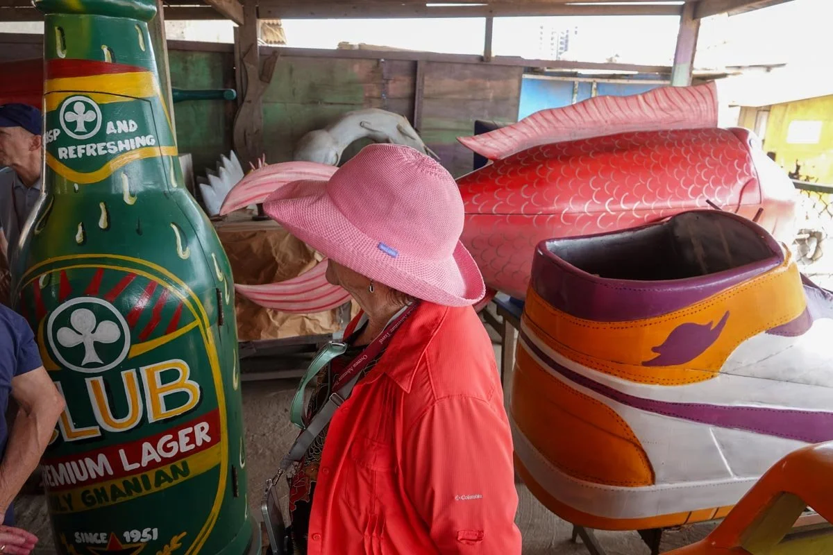
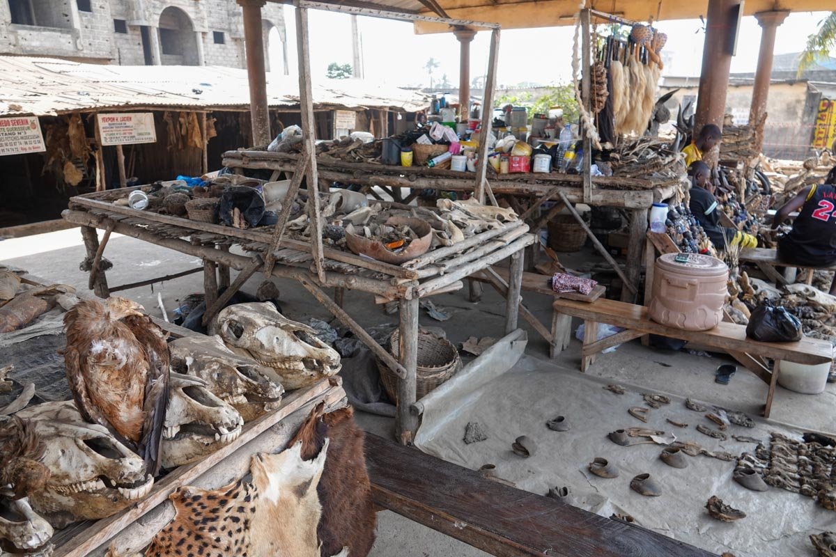
Togo is one of the countries in the world where Voodoo is a major religion. Voodoo was born in the West African area from Ghana to Togo to Benin.

The photo below was taken at a famous Voodoo fetish market. It was quite an experience.

We are now in Benin, right next to Togo. Benin is also a hotbed for the Voodoo religion. Snakes play an important role in Voodoo in Benin.

This whole area of West Africa was also the primary area for capturing, selling, and shipping slaves to the new world. Different countries shipped slaves to different areas of South and North America, depending on which Colonial power ruled the area at the time. Below is Goree Island, one of the first transport locations of slavery to the Americas from Senegal, just off the coast from Dakar.

Cape Verde is a group of ten islands, each one different in some ways. Below is Fogo Island, or Fire Island. It's the youngest island, very volcanic and still very active.

Our last visit was to The Gambia. Below is a photo from a visit to a fishing village which was highly entertaining as you can see.

Accra, Ghana

Accra is the capital and largest city of Ghana. It's located on the southern coast of the Gulf of Guinea which is part of the Atlantic Ocean.

While Accra itself has a population of about 300,000, the greater Accra region has a population of five and a half million people.

Outposts and forts were built here by the Dutch, Swedes, Portuguese, French, and Denmark before largely being ruled by the British.

English is still the Official language of Ghana and all signs were in English.

Ghana was formerly known as the Gold Coast as they had, and still have, an abundance of gold resources.

I didn't find Accra to be impressive. It was run-down and dirty and in need of a tremendous amount of maintenance.

I felt somewhat bad in that if I saw an impressive old building, it was always left over from the Colonial period of Ghana, such as the building below.

Most streets and areas were very simple and rather humble looking, such as the street below.

Unfinished buildings, rundown buildings, and broken vehicles and equipment were common to see.

I was never certain if we were actually in Accra itself or just in the greater Accra area. It all blended together.

Below is a neighborhood that was not atypical of the Accra area.

This market was right across the street from our hotel. The entire market was unimpressive. You might also notice that the woman in the middle was yelling at me for taking this photo. Our local guides all said that the locals understood that every time a tourist took their photo, the tourist sold the photo for millions of dollars and of course, they didn't receive any money. Personally, I've never received any money for my photos of people but anyone is welcome to send me millions of dollars.

I included the photo below to try and show that Accra does have some new and upscale buildings, though we didn't see very many of them.

I want to include the photo below of the beach. We were told that Ghana and most of West Africa had many really nice beaches and they are on the ocean.

The surprise to me was that we seldom saw any people on the beaches and it was even more rare to see someone in the water.

This was our hotel, from the back. We stayed at the Movenpick Ambassador Hotel, reported to be a five-star hotel.

Below is the Kwame Nkrumah Memorial Park and Museum. It was a large area with this memorial, a bronze statue, and a museum plus large water features. It was built on the former British colonial polo fields so they had plenty of space for it. Dr. Kwame Nkrumah led Ghana to their independence from Britian and headed the first government that followed. According to our local guide, the US CIA helped overthrow this first government due to Dr. Nkrumah encouraging other West African countries to gain independence plus they were trying to develop nuclear power which worried the US during the Cold War.  

Ghana is just a few degrees north of the Equator so it's very tropical, think high heat and high humidity. They have plenty of water though they have a short rainy season.

The photo below is the Volta River which is a short drive from Accra. It's Ghana's main river system and very large. You can see a small group of fisherman in the boat.

School children were easy to spot in Ghana as well as the rest of West Africa. We could always tell by the uniforms that they wore, which were different for each school.

The use of public space was interesting in Ghana. We saw laundry drying on the ground along roads and in other places that got good sunlight. 

Below is a roundabout on a public roadway near the ocean and some of the locals were using this roundabout to dry their fish.

Erico Carpentry Shop

We had an interesting visit to the Erico Carpentry Shop. They specialize in building coffins. I never learned how they got into this specialty but it was different and interesting and I love visiting small businesses.

If you look below the sign in this photo, you will see some of the coffins lined up for sale. This was a roadside business, across from the beach.

The nearest coffin is a tennis shoe coffin. They had several different shoe coffins. You can also see the Ghana Airlines coffin behind it.

The next photo is the above tennis shoe coffin, opened up.

Vicky is checking out a beer coffin below. I think she might have been thinking about me.

You can also see a different shoe coffin and a fish coffin to Vicky's right side.

The special feature of the beer coffin, we were told, is that it doubles as a storage cabinet in your home until such time as you die, then it becomes your coffin.

You can see the shelves inside the beer coffin below, good for storing dry goods, vegetables, beer, fruits, etc.

This gentleman showing us the beer coffin seemed particularly proud of this coffin...and I can see why.

Below are two more coffins that I found interesting. The chili pepper coffin would be perfect for my grandson, Archer, except that he's only nine years old.

Still, Archer loves his hot sauces, makes his own hot sauces, and carries around a bottle of hot sauce for when he eats a meal.

For myself, I thought the US money coffin was intriguing, though I'm not particularly impressed by the drawing of Ben Franklin.

Aburi Botanical Garden

The Aburi Botanical Garden is in the Akwapim Hills in the eastern region of Ghana. The garden was established by the British and opened in 1890.

The garden is 160 acres so it's a large space. It is on the site of a former sanatorium, built in 1875. The palm trees below were planted in 1895.

We didn't get to see much jungle area in Ghana, other than parts of the botanical garden, such as below.

Below is the "monkey pot tree" which is in the Brazil nut family. It's a large, deciduous, dome-shaped tree. The fruit is shaped like a cooking pot and contains edible seeds.

Next was a Nutmeg tree with its small yellow fruits. Nutmeg is ground from the seed and Mace is ground from the seed covering, so two spices from this tree.

The next tree below is a silk cotton tree planted in 1924.

The next tree is a dead tree but some artists have had a field day carving it up.

It is hard to see but the carving is people trying to get to the top of the tree, or ladder in our society, by climbing over each other and pushing others down, with few exceptions.

You can also notice a rusted old cement mixer behind the dead tree on the left.

This dead helicopter sits in the garden. I include it because we frequently saw old broken vehicles and equipment in Ghana, always left where it died.

Tetteh Quarshie Cocoa Farm

A guy named Tetteh Quarshie determined that Ghana would be a perfect climate for growing cocoa beans. He could not, however, obtain any cocoa beans. He ended up smuggling some beans out of Equitorial Guinea in order to start his cocoa farm here in Ghana, back in 1879. Cocoa beans eventually became Ghana's leading export for many years and they were the world's leading cocoa bean exporter. Today, Ghana is second in the world in cocoa bean exports.

This farm, today considered the Eco-museum of Cocoa, is one acre in size and managed by the Cocoa Research Institute of Ghana.

This post is for all you chocolate lovers out there!

I was surprised that this cocoa farm did not look like a farm to me. I'm used to orchards and vineyards that are in rows and organized. 

We were told that other trees are allowed to grow to provide needed shade for the cocoa trees. To me, it looked more like a wild forest.

Below, you can see one of the original cocoa trees that was planted in 1879. There are only three original trees left. It seemed small to me for its age.

You can see the yellow cocoa fruits and the beans inside in the photos below. There are also some dried cocoa beans on the table.

Below you can see the cocoa beans, wrapped in their covering, inside the fruits.

My last photo is out of focus but it's the best I could do in a hurry. It's a cocoa bean after removing the cover. It turns brown after drying.

Grandpa's (Furniture Business)

Most businesses in Ghana are located right next to the roads. Roads are lined with every type of business that you would expect to see. We didn't stop and visit very many as most were not overly interesting. Still, I want to include a few and here's another one. The business name (or Merchant's name) was just "Grandpa's". They sold furniture. I was never sure if I met Grandpa as everyone working there looked too young to me, but I like the name. The business was in a thin strip of land between the road and the jungle.

Below is the "workshop" area, just to the right of the photo above. They certainly had some nice pieces of wood and I'm sure it was all hardwood. Their tools were simple.

The mid-production area is below. They had a decent sized work crew and they were producing quite a bit of furniture.

Now for a look at some of their finished work, below. All of their work is unique, nothing is done by a template.

They even had some advanced creative work being done in their shop and it was all impressive.

Shopping in Reverse

Our local guides told us that in Ghana, people usually don't "go shopping." They said that for the most part in Ghana, the "shopping comes to you."

For example, they said that people don't wake up, eat breakfast, and drive to work. Instead, they wake up, drive to work, and eat along the way.

Whether you want to eat something, drink something, or purchase a dry good, it will be offered to you.

Every time there was a red light or a traffic stoppage, there were people selling their goods. You could get anything you wanted.

Below was an area nowhere near a red light but I am certain that it's a place where the traffic regularly comes to a stop, which is not uncommon in Ghana.

While there are shops selling the same goods along the road, should someone want to stop and shop, these vendors (mostly women) sell to those that don't want to make a stop but just want to make a quick purchase. Below you can see these ladies waiting, followed by a van pulled to a stop.

The photo below was in town at a line of cars stopped for a red light. This was a red-hot selling spot.

The woman below was well out in the country. But even way out in the country, there are regular traffic stoppages due to all the traffic and poor roadways.

Driving from Accra to Lome

On this day, we drove from Accra, Ghana to Lome, the capital of Togo. It was a drive of 125 miles, but it took eight hours. We made several stops, including lunch, but it was a very slow drive. The worst of it was that we had to drive over several hundred speed bumps on the main road. On our large bus, the driver slowed to a stop and then crept over each one. We also passed through many small villages and it took us over ninety minutes to cross the border from Ghana to Togo, which was quite an experience in confusion and uncertainty.

Some of the land was on the flat side but much of it was hilly. In the photo below, this was a hilly area. I will point out several things of note. First, most Ghanians are farmers. You can see many farms in this photo. The farms that we saw were all very small. I'm not sure I ever saw a farm here that looked much bigger than one acre. Plus, the farms don't look like our farms. Orchards, for instance, are never orderly with trees in rows. Another thing to point out is that I thought the houses looked very large. They are large but then we learned that most of the houses are multi-family homes. Houses have multiple generations living in them and often with more than one family of the same generation.

We drove through many small towns and villages. I'm just including one such village below. Most small villages were a hotbed of activity and often it took a long time for our bus to pass through them.

At least in this village, there was a minimal amount of vehicle traffic.

The brick-making business was perhaps the most common business of all in Ghana. We passed many dozen brick-makers along this road and every other road.

Another site that was extremely common in Ghana was houses or businesses with stacks of bricks on the road in front of them. Building houses and other buildings is a "pay-as-you-go" operation. People build the house as they have the money rather than taking out a loan and building it at once. It's common, our guides said, for some people's houses to take 30 or 40 years to finish. Plus, some areas don't charge taxes on the houses until they are finished...so some people never finish their house, according to our guides. 

Other reasons for our long bus ride for such a short distance were all the reasons that you might expect, such as below. We passed several herds of cattle.

In certain areas along the way, the soil had a very high clay content. As expected, these areas made and sold clay pots of every description.

The next photo is just a glance down a side street in a small village. The smaller and more rural villages were often much cleaner than the Accra area.

We were told clearly and specifically that we were not allowed to take any photos in the border crossing area between Ghana and Togo. There were guards all about.

Still, it took over ninety minutes to cross the borders, and I was bored as all heck. I must have accidentally taken the photo below...my bad. Welcome to Togo.

Togoville Primary School

Our tour company arranged for us to visit a primary school in Togoville, Togo. Togoville is down the coast from Lome and sits on the northern shore of Lake Togo. Our group took a boat across the lake to the town of Togoville and the primary school. We visited 6-7 year olds, 9-10 year olds, and 11-12 year old classes.

In the first photo below, our local guide is in the center and giving our group's gift of pencils, books, etc. to the principal, who is on the right.

These children work under very minimal conditions. Below are some of the 6-7 year old class.

Class sizes go up to sixty (60) students in a class. And don't forget about the heat and humidity.

The students have no books. All learning materials are written on the blackboard and the students must write the information into their notebooks.

Everything is in French in Togo.

School is free in Togo but the students must purchase their own supplies. For this reason, girls are often not sent to school.

Below is a girl in the 11-12 classroom and you can see she is writing in her notebook.

Akodessewa Fetish Market (Voodoo Market)

On this afternoon of a 100-degree day with high humidity in the Akodessewa District of Lome, Togo, we visited the world's largest Voodoo market, which was very dusty.

The Voodoo market featured monkey heads, skulls, crocodiles, dead birds, and bones and skins of many other animals. It was a large market.

We were told that Voodoo is mainly a positive religion. They said that most of the festishes, talismans, charms, dead creatures and their parts are used to help people and to heal them or bring them better health, etc. They said that it's unfortunate that so many in the West only dwell on the negative aspects, such as sticking pins in dolls, etc.

An interesting note is that in Togo, 20% of the people are Muslims, 30% are Catholics, and 50% believe in Voodoo, but 30% of the Catholics also worship Voodoo. 

Voodoo followers believe in a single, supreme godhead that can be equated with the Catholic God. Their deity is known as Bondye, "the good god."

With all this information, I was still confused by some of the statues that we saw at the Voodoo Market, such as the one below.

Near the end of our time here, we were ushered into a very small hut to meet with the head Voodoo priest. He gave us several talismans, such as the one in the photo below, and told us how to use them and for what purpose.

This was on January 17th, 2024 and the San Francisco 49'ers, my team, were playing the Green Bay Packers in four days. I asked the head priest if he had a talisman that would help the 49'ers beat the Packers. He never smiled or changed expressions, he just told our interpreter, "No."

I'm now going to skip ahead two days. We were by then in Benin. We stopped at another Voodoo Temple. This time, the priest or whoever he was, was much younger.

I again asked if he had something to help the 49'ers win. He said that he did indeed, and in another minute, he was wrapping a Python around my neck. He assured me that it would squeeze the life out of the Packers. And of course, the 49'ers won the game.

Unfortunately, I was already home by the time of the Super Bowl...

Togo Fishing Village

This morning, we stopped to see a fishing village in Togo while on our way to Benin. They fish here six days a week and take Wednesday's off. We were told that different fisherman fish in different ways. Some go out, throw their fish nets and catch their fish, and come back in. Others go out, set their nets, and then go retrieve them the next morning. Still others stay out even longer to fish.

Perhaps the most interesting thing is that the only currency is "fish." Everyone that works here gets paid in fish. No currency is involved in this fishing village. If you need some money, then you must sell some of your fish.

I'll start our visit with a fishing boat coming into shore. These boats are handmade and are monsters. They use big timbers to make the boats and the boats must weigh a ton. To land a boat and get it up on the shore takes something like twelve to eighteen determined guys. In the first photo below, you can see two boats coming ashore. You might notice sleds and rollers under the nearest boat, which are laid down starting at the beach. There is a long rope attached to the front of the boat and in the second photo, you will see that there were maybe twelve to sixteen guys pulling on the boat to get it up on the beach. They were all working hard.

Once the boats were landed on the beach, the activity became magnified. Most of the work involved the nets, both taking out the fish and re-wrapping the nets.

In the next two photos, you will see a couple taking the fish out of the net, followed by two others re-folding the same net.

Most of these fish were sardinellas and petite fritures, I believe. Most of the fish that we saw coming in were very small fish.

We were told that they do catch some larger fish on the boats that go further out into the ocean and that stay out fishing for a longer time.

In the photo below, you can see a new fishing boat being built on the right side. They use heavy timbers and work right there on the beach to construct it.

I took a follow-up photo of the above for the net gatherers. We were told that refolding the nets was a key job. You might also notice that the woman is carrying her baby behind her back. This was common everywhere in West Africa. Babies were lugged everywhere the mom went. I never heard one cry out of a single baby.

It was obvious that no one was going to steal a boat. The boats weighed a ton. The motor on the boat, however, was a different story. Motors were taken home.

Fish were being dried in many places on the beach. Some groups of fish were small and others were very large as you will see below.

Head Fisherman's House

We were introduced to the head fisherman while at the fishing village. He is evidently in charge of the whole fishing village and their fishing association.

He took us into his house to see the house and to see his wife smoking some of the fish caught on this day.  His house is right on the fishing village beach, not far from the ocean. Below is the entryway to his house. You will notice as we go through the house that it has no roof.

This next space is what I would determine to be similar to our garage. It has some fuels, lumber, and a garbage can.

This space appears to be for laundry and perhaps other things. The garage area is to the right of this space.

Below is a bedroom, and the only bedroom that I saw. You might notice a youngster sleeping in this room on the floor on a tarp.

Below is the kitchen. This is for their regular home cooking. The fish smoking is done in space behind where I took this photograph. You can see the work table and their fire.

Now we meet his wife and she is smoking some of their fish. She has stacks of fish in layers above the fire. As we arrived, all the trays were stacked up on top of each other.

Smoking and drying are the two ways that they preserve their fish. The photo below is some of the dried fish that she just smoked.

The last photo below is not part of the house. It's a short distance from the house and beach. We saw stacks of wood all over this part of the coast. 

People sell wood and people use wood to cook and to smoke fish. I don't believe that wood is needed to provide heat as it never really gets cold here.

Wood comes in many lengths for various purposes. Shorter pieces are for cooking while longer pieces are for construction purposes.

Driving into Benin

After leaving the fishing village, it was only a short drive to the Togo and Benin border. This border crossing was quick and easy.

These photos are bus photos. 

The agriculture in Benin was on a larger scale than in Togo. We saw bigger fields, palm and banana orchards, and row crops such as tomatoes, squash, carrots, and lettuce.

We also passed though a number of small villages along the way.

I will also include a couple of photos to show some more of the housing that we saw along the way. It seemed to me to be more impressive than in Ghana or Togo.

The small villages were always interesting. We didn't pass through as many in Benin and they were not as crowded, plus way fewer speed bumps.

The photo below might seem out of place in a small town but rest assured, the women in these countries really took pride in their hair as well as their dresses.

Below is a small shop. I only included this photo because I was so impressed with the woman shopping here and the amount she had on her head.

We finally saw some really nice crops of vegetables as we neared our lunch stop.

Pythons Temple

We are now in the town of Ouidah, in the southern part of Benin. Our first stop after lunch was the Temple of Pythons. It's a fascinating, historical, and sacred temple which houses dozens of python snakes. It serves as a Vodun temple, a religion which was an inspiration for other religions, such as Voodoo. The snakes are important religious symbols and are highly respected. I know they had my respect. I was a little lost on their spiritual aspect, but I can respect it, nonetheless.  

The historical aspect goes back to the 1700's when the king of Ouidah sought refuge in the forest during a war. Pythons emerged from the forest and prevented his capture and to show his gratitude, he created three monuments, one of which is the Pythons Temple. The temple is in the center back in the photo below. It's not very large.

This is a closeup of the statue that is out in front of the temple. Since the tour didn't start until we were inside, I never heard an explanation about this statue.

Vicky is getting up close and personal with a python. She didn't seem to have any problems snuggling up with a snake.

Below is inside the Temple of the Python. It's a concrete building with a clay roof. It houses some 60 pythons, known as Royal Pythons. 

People come into the temple to pray but can only ask for positive things. They sit around the bottom of the pit, with some holy water, and the snakes all about.

I suppose this is called a "snarl of snakes." I wasn't able to count them.

The pythons are not fed in the temple but let out once a week to go and feed on chickens, mice, and rats. Then they return to the temple.

Our temple guide said that if neighbors find one of the pythons in their house, they gladly return it to the temple.

I had my turn wearing a python too. But I did it for a good cause...to help the 49'ers beat the Packers in the NFL playoffs, a positive thing.

Ouidah Slave Trade

     Slavery started in the world thousands of years back. It started in Africa at least hundreds of years back. But the topic in West Africa was mainly the Transatlantic slave trade. It was probably started here by the Portuguese in the 1480's. The Dutch, English, and French also became major participants after establishing colonies in the New World. The first slaves were not landed in English America until 1619, in Virginia. The transatlantic slave trade reached its peak in the 1780's and then started decreasing until outlawed.

     Best guesses estimate that about 12.5 million slaves were sold and transported in the transatlantic slave trade. Of that number, over one million were sold and transported out of Ouidah. It was one of the most active slave trading ports in all of Africa. Most of this area was then controlled by the French but the Portuguese held the slave trading post. Because it was Portuguese, these slaves were shipped to Brazil. Slaves were shipped from here into the 19th century, including many years after it wad declared illegal.

     Today, the people of Ouidah and Benin have determined that the history of slavery should not be forgotten. To that end, they have been developing tourism based, in part, around the historical transatlantic slave trade that happened here.

     We made five stops of historical significance of the transatlantic slave trade out of Ouidah. Below was the first. I believe that this (or the original tree at this location) was called the "tree of forgetfullness." Slaves were branded here and walked around the tree to forget all their family, friends, lives, etc. It was thought that they would then make better slaves if they could forget their lives prior to slavery. Slavery started here in 1725 and lasted until 1848. Slavery in Togo started 100 years earlier.

     We were told that the majority of slaves were captured from inland Africa. Some were captured locally but mostly from the interior of Africa. It was done by the dominant tribe. Our local guide told us that slavery began under this tree. I objected and suggested it began when they were captured. We had a dispute about this. His position was that when captured, they were "captives." He said that captives were a tradition in Africa when tribes held wars against each other. He said that they were treated much better. He said that these captives only became "slaves" when they were sold here. I told our local guide that I wouldn't argue his semantics but that I thought they became slaves when captured.

     Our guide said that the tribes went inland and captured people at night. These people were shackled and marched through the jungle all night long, both for secrecy and for captives not knowing where they were going. After arriving in Ouidah, they were put into dark buildings, at the location below. The buildings had no windows and solid doors. They were locked in here for extended periods, like days, while the weak died. The ones that survived were considered to be quality slaves.

     After slavery was outlawed, these buildings were torn down, no doubt to hide the horrible evidence of what they had done. Still, this is the location of the buildings.

I only include the next photo to give you an understanding of the extent of the locals making this a tourist attraction. This path led us from the former building site above to the site of the slavery auction.

This tree of return is in the background. The auction house is to the right side but not in the photo. The idea with the tree of return is that the slaves would walk around it three times, believing that if they did so, and later died outside of Africa, then their soul would return to their homeland.

     If the captives died marching to Ouidah or in the darkened buildings, and many did, then they were buried in the Cemetery of Slaves. It was simply a large, deep pit in the ground which held many such bodies. The sign has three colors: brown representing the slaves, red to represent their blood, and black to represent their chains. I suspect their were many more such burial sites.

The final two photos are the end of our slave walk. This is "The Gate of No Return." From the beach here at Ouidah, slaves were put into small boats and rowed out to the slave ships. This is the new symbolic monument to mark the location where this happened. The slaves knew that they would never come back to Africa.

My first and main confusion about this slave information and the slave trade was this. Since the slaves were so valuable, why were they treated so poorly?

Huge numbers and percentages of the slaves died before they were even sold from horrible treatment and then huge numbers died on the ships to the Americas.

It seems like very poor stewardship of such valuable property.

Secondly, I could not see any remnants of the wealth that must have been accumulated by the chief of the local tribe that sold the slaves. Between slaves, gold, ivory, palm oil, etc., it seemed to me that I should have been able to see something leftover from their glory days. I couldn't find anything.

Cotonou, Benin and Porto-Novo

     We stayed in Cotonou for a couple of days. Cotonou is the largest city in Benin with about 750,000 residents but there are over two million people in the greater urban area. It's situated on a strip of land between the Gulf of Guinea and Lake Nokoue. Cotonou is the seat of government in Benin, but not the official capital, which is Porto-Novo.

     I thought Benin and Cotonou seemed more prosperous than Ghana or Togo. I would definitely say that we saw more infrastructure projects such as road improvements and large building works here.

     Our first stop on this day in Cotonou was the Warrior Woman Statue. It stands in a huge public square and is almost 100 feet tall. It was evidently built to honor the world's only all-female army. That army was part of the Kingdom of Dahomey, a West African empire from 1625 to 1894. The statue was erected in 2022.

     Next we visited the "seven deity temple", or something like that. It was a Voodoo temple that looked like a termite mound, on purpose. You can see some of the deity heads on the fence surrounding the temple. Voodoo was also very active in Benin.

     We have now driven from Cotonou to Porto-Novo, the Capital. Here, we visited the Great Mosque of Porto-Novo. It was built between 1912 and 1925 during the French period in what is now Benin. Our local guide told us that this mosque was built by former slaves who had been sold and shipped from here to Brazil. When a group of these former slaves returned from Brazil to Benin, they wanted to do something special to celebrate. They decided to build a mosque, since they were Muslims, and this area was a Muslim area. It might seem peculiar but these former slaves from Brazil had only seen Catholic churches in Brazil. For that reason, the great mosque resembles a catholic church with a certain African-Brazilian architecture. Unfortunately for the returning slaves, the local Muslims refused to use it as it didn't look like a mosque to them. So, this mosque has gone unused, as a mosque, for its entire existence. It's too bad as I think it's a beautiful building. The local Muslims later built a mosque right next door which you can see in the second photo below.

In the second photo, of the new mosque, you can see the great mosque on the right side of the photo. The local Muslims use the new mosque.

On our walk from where we parked the bus to the Great Mosque, we passed a small street side restaurant. They had a handful of customers as it was getting near lunch time.

I think the first open pot is a fish dish, perhaps in a tomato sauce with vegetables. The second photo is a beans and rice dish. I can attest that it smelled very good.

Porto-Novo Five-Day Market

     We walked around the so-called "five-day market." It was called that because it operated every fifth day. On the other days, markets operated in other nearby villages. That system seemed odd to me but that's how our local guide said that they did it. On another note, this market is in the Muslim area of Porto-Novo.

     The first photo is here as a point of explanation. This is the neighborhood of the Great Mosque and the five-day market. We were not scheduled to visit the five-day market. Our regular guide just sort of moved us along through the market but it seemed like he was stalling as we passed along. You can see our local guide in the photo below. You might notice his phone in his right hand. He later put it in his pocket where a pick-pocket eventually stole it from him. It was a guy that had followed us from the street side restaurant. The thief had approached me several times and each time I told him to go eat his lunch, which he was carrying with him. Eventually, he stole our local guide's phone. Our regular guide took us through the market while our local guide hired some other local people to track down his phone, which he eventually did, at what cost I don't know.

  The first three photos below of the market are self-explanatory. It was a local market and not very unusual.

    My only comment on the next photo is that, again, this person objected to my taking this photo. It was difficult to gauge people. Our guides only told us that we needed to ask the person's permission to take very closeup photos, specifically of that person. I never took any closeups and only tried to get the whole store in the photo.

     I have one comment on the last photo. Remember that this is the Muslim section of Porto-Novo but here we see a liquor store that was well provisioned.

Chief of local Tribes

This was an interesting visit. It was a visit to a man who was alternately called the Prime Minister and a Chief, and who had previously been a King. Evidently, this man had been a king, back when this area had kingdoms. Since kingdoms are gone, he is now called a chief or prime minister. He is evidently the head of all the chiefs of all the tribes in this area of Benin. Having said all that, we certainly had an unusual visit here.

Below is a photo I took of his royal palace which is not where he lives but where he conducts business.

Below, the king, his queen (far left) and two others greeted us on our arrival. The two servants poured water on the ground for something which then meant that we walked through the mud to enter the palace. Still, it was nice to be welcomed.

    The whole event here was uplifting. It involved a lot of hokus-pokus, singing, chanting, and offering. There must have been thirty women in the king's court who performed, sang, played various musical objects, and danced about. The "offering" was a snack of bitter cola nuts and schnapps. Yes, schnapps is an alcoholic drink. 

Towards the end of this event, the king and queen invited everyone up to join in the dancing. You can well imagine who the first one to join in was.

We eventually got our own introduction to the Chief. He also did a question and answer session and he seemed genuinely wise by his answers and also by the questions that he asked us.

Lake Nokoue' transportation

     Cotonou sits on a strip of land between the Atlantic Ocean and Lake Nokoue'. The lake is on the northern border of Cotonou. This lake is large at twelve miles wide by almost seven miles long. To be more accurate, the lake is more like a lagoon. It's quite large but also quite shallow.

     This stop on our tour will involve three separate posts. The reason for this stop was to visit the town of Ganvie, which is a lake village. It's built mostly on stilts and sits in the northern edge of the lake.

     The first photo is a transportation hub for both locals and tourists who are going to Ganvie, from Cotonou. The pier is on the right side which is primarily for the tourists.

Below, you can see the two boats which our group used to go to Ganvie. You can also see some of the locals, here to either buy or sell things or to go to town to either buy or sell their goods.

I just included the next photo because I was amazed. You can see this local woman, standing in her boat starting to paddle off, but still with her goods on her head! That takes ability and experience!

The rest of these photos are just boats going to or coming from Ganvie. I would say that most often, women had a sail on their boats. Men most often just paddled their boats.

Everyone out on the water was working by hauling goods one way or the other. We didn't see anyone out in the lake just paddling for pleasure.

I'm not sure how this last guy managed to navigate with his load.

Ganvie Fishing on Lake Nokoue'

The primary means of earning a living for the people of Ganvie is fishing. Their fishing is primarily small-scale fishing done on a low-capital and low technology basis.

Most fishing is done by individual fisherman. The only fishing that we saw was by using nets. We saw throw nets, basket nets, and larger netted areas.

They fish for about 30 of the 78 different species of fish that live in Lake Nokoue'. They also catch shrimp, crabs, oysters, and mussels.

However, about 85 percent of the fish caught are in the Cichlid, Clupeidae, and Penaeidae families of fish. I'm not familiar with any of these fish.

Fish are then often taken into town and sold, allowing Ganvie residents to purchase other goods to bring back to Ganvie to sell to others. This is their economy.

And while fishing being the primary aspect of their economy makes perfect sense to me, I'm not sure that I would want to eat anything caught in this lake.

You can see some of the fish baskets in the photo below. We saw groups of these at several places in the lake. I'm not sure how they work.

In the next photo, you can see that this young fellow just cast his net into the water behind his boat.

The next photo is one of many fish farming areas that we saw. These areas have opening for the small fish to swim in but then they grow and can't exit and get netted.

The next two photos are people out fishing with nets.

The last photo is in the village of Ganvie. You can see fishing nets hanging from the drying rail. We saw plenty of fishing nets being dried.