Oslo to Borgund

We left Oslo by bus for a ride to Flam.  This post will just cover the first part of the journey.  For me, I like to travel by large bus.  I get a high seat, large windows, and I get to see what the country is really like, outside of the big cities.  My goal here is just to show some typical scenes on our drive from Oslo to Borgund, on our way to Flam.  These are mostly moving bus photos but will give a good idea of the ride.

We spent a lot of miles seeing sights such as the first photo.  The land was hilly to mountainous.  Most of the land was covered with forests, both evergreen and deciduous trees.  There were almost always high mountains in the background that were covered with snow.  Many of the houses and barns looked like the buildings in this photo.  The highways were not very busy most of the time and the roads were good.

101-DSC01739.jpg

The second photo is part of the small town of Hemsedal.  We ate lunch at the Hemsedal Café but didn’t get a chance to walk around town.  There wasn’t too much to see anyway.  It is on National Road 52 and getting close to the half way point between Oslo and Bergen.

102-DSC01765.jpg

We did more climbing after leaving Hemsedal and we seemed to get above tree line.  The snow was thicker and we were now in the snow.  Our bus made a road stop at the place in the fourth photo.  This was at 3,700 feet elevation.  In Norway, no matter what the location, someone had a house or a summer cabin there.  My guess is that the house in this photo is actually a summer cabin.

103-DSC01772.jpg
104-DSC01782.jpg

Borgund was our third stop of the day.  You can see the Historic Borgund Stave Church in the last photo.  The old church is on the right, built in 1180 with the bell tower next to it, and the new Borgund Church is the red one on the left.  The new church was built in 1868 and has been the primary church since that time.  The old church has had some restorations but is largely as it was built.  The walls are formed by vertical wooden boards, or staves, and hence the name “stave church”.  We stopped and visited the old church and the museum for about an hour.  The old church has no lights and very little light gets inside, so I took photos but they said no flash, so the photos are pretty dark.  It wasn’t much to see inside anyway except some nice carvings in places.

105-DSC01790.jpg

Borgund to Flam

This will be the rest of our drive on this day that started in Oslo and ended in Flam.  It was quite interesting driving for me.  For example, we learned that Norway has over 900 road tunnels.  Our guide said that something like 20% of those road tunnels are in the Bergen area, which is where we are headed.  Tunnel length adds up to hundreds of miles worth.  But with all the mountains and all the fjords, I guess it just makes sense.

The first photo might seem silly but this is the entrance to the Laerdal Tunnel.  This is the world’s longest road tunnel.  It is 15.23 miles long.  The tunnel connects Laerdal and Aurland.  The tunnel is two lanes but seemed to have plenty of room.  Construction started in 1995 and the tunnel opened in 2000 at a cost of about $113 million US.  That almost seems cheap to me.  I noticed as we drove the tunnel that they had some light changes.  If you look at the second photo, most of the time the lighting was just a central overhead strip of white lights, like you can see in the middle of the photo.  But sometimes, we saw other colors such as you also see in the second photo.  We learned that since the tunnel is over 15 miles long, they had safety concerns.  The lighting changes in the tunnel are to break up the monotony of the long tunnel drive.  They certainly got my attention and yes, they broke up the monotony.  

106-DSC01831.jpg
107-DSC01833.jpg

Aurland was at the other end of the Laerdal Tunnel.  The next three photos are in Aurland, another small village of about 1,800 people.  Aurland gave us our first look at a Norwegian fjord which you can see in the third photo.  A fjord is a long, narrow water inlet with steep sides or cliffs that was created by a glacier.  I walked out on a dock and took the fourth photo looking off to one side of Aurland.  It’s a pretty typical Norwegian coastal village.  Most of Aurland looked to be very nice houses and businesses, well-kept and modern.  I couldn’t help but include the last photo which was near to the docks.  I loved the tulips, the dandelions in the grass, the milk can by the door, the fishing net on the house and all the rest.  But I especially loved the fish drying on the wall to the right of the door.  Those are not decorations but real fish being dried.  I almost asked if this place was for sale.

108-DSC01840.jpg
109-DSC01844.jpg
110-DSC01847.jpg

Flam

This is Flam, Norway.  Flam is on a fjord that branches off Norway’s longest fjord.  This fjord branch flows through Aurland, Vik, and Laerdal and is an 18 mile long branch.  Because they can, I guess, Flam attracts cruise ship traffic.  Flam is a small village of only 350 people but they get as many as 15,000 cruise ship tourists a day and about 500,000 cruisers a year.  We arrived in Flam by bus on the E16 highway.       

Flam started as a village in 1340.  Flam, the name, is derived in Old Norse to mean “plain, flat piece of land” or “a plain between steep mountains”.  It’s still a small village and easily walkable.  I am not sure what the cruise tourists do here all day.

You can see a photo of the harbor in the first photo.  I took the first photo from our hotel to give myself some elevation for the photo.

111-DSC01867.jpg

We stayed in the Fretheim Hotel which was quite nice.  You can see Vicky by the front door.  The hotel is a refurbished manor house from the 1800s.  It has certainly been upgraded since and it was really a nice place to stay.

112-DSC01890.jpg

We went down to the other end of town to visit a farmer.  You can see the other end of town in the third photo.  The river did not seem to be running very high when we were there.

113-DSC01870.jpg

You can see the sheep farm that we visited in the fourth photo.  Our guide and this farmer told us that farmers have a difficult time making a living by farming in Norway.  But what a beautiful place to live and work!

Our guide said that most farmers have to do other jobs to generate enough income to make ends meet.  Farmers might process trees, fish, rent out rooms, generate power, or do jobs in town.  

114-DSC01877.jpg

On a side note, several of our tour members told this farmer that they were from Minnesota and that they knew farmers in Minnesota who came from Flam.  The farmer was aware of this and he told us that today, there are thousands more Flam farmers living in Minnesota than in Flam.

The last photo is the farm wife and she is with her three motherless babies, for which she provides their motherly care.  The family was very nice and we enjoyed our visit very much.

115-DSC01885.jpg

Flam to Bergen, by Train

Flam is a small village but it has lots of transportation options.  Most people arrive by cruise ship.  We arrived by bus on the highway but left by train for the rest of our trip to Bergen.

The train to Bergen took two trains.  The first train was from Flam to Myrdal and the second train was from Myrdal to Bergen.  The first leg was on an old train that was billed as “one of the world’s most beautiful train journeys”.  You can see the first train in the first photo.  This was it as it was leaving Flam (the day before actually, since we were on it the day we left).  The train followed the river much of the time but we passed a wildly diverse landscape along the way.

116-DSC01873.jpg

The second photo shows several things of interest.  First, it’s easy to understand why Norway has so many road tunnels.  Second, it’s very steep mountains even if not that high.  Third, we saw lots of waterfalls along our way.  There was water everywhere.  This is just a little side creek flowing into the river that we were following to Myrdal.

117-DSC01905.jpg

We changed trains in Myrdal.  Myrdal was not actually as cold as it looks in this photo.  We left our cute old historic train and boarded a new modern electric train.  You can just see the edge of it on the right, the red train.  It was extremely quiet, comfortable, and smooth riding.  Our train journey had 30 potential stops along the way but we didn’t stop at most of them.  I guess no one was getting on or off at those places.

118-DSC01916.jpg

The last two photos are just photos from the train ride.  The first was taken closer to Myrdal of a lake along the tracks and the second was a small farming area closer to Bergen.

119-IMG_7656.jpg
120-DSC01936.jpg

Bergen, Norway

Bergen was founded as a city in 1070 by King Olav Kyrre and its original name meant “the green meadow among the mountains”.  Bergen sits on the far west coast of Norway and it served as the capital of Norway in the 13th century.  It was the largest city in Norway until it was overtaken by Oslo in the 1830’s.  Today, Bergen is Norway’s second largest city with about 280,000 people.  Since its start, Bergen has been a fishing and trading center. Today, Bergen is an international center for aquaculture, shipping, the offshore petroleum industry, sub-sea technology and a national center for tourism, finance, media, and higher education.  According to a woman who works and owns a local restaurant, the early days of Bergen involved fishing, farming, distillers, and prostitutes.

The municipality area around Bergen covers 180 square miles but Bergen is on a peninsula and many of the suburbs are on islands.  The population of the municipal area is about 420,000 people.  But Bergen seemed like a smallish town to me.  The main area of Bergen was rather compact and highly walkable.  Bergen has also suffered from numerous fires over the years, so its architecture is also very mixed.  I very much enjoyed our stay in Bergen.  

The first photo is my vision of Bergen.  Our hotel was immediately to the left of this photo.  This street is right on the harbor and I suspect that these are some of the oldest buildings in Bergen.  This was a lively area of town and popular with both locals and tourists from what I could see.  We spent quite a bit of time here.

121-DSC02007.jpg

If you walked straight ahead in the first photo until the end of what can be seen in the first photo, and then looked to the left, you would be seeing the second photo.  Bergen sits at the bottom of the mountains and the mountains are still mostly just forests.

122-DSC02011.jpg

One of our first explorations in Bergen was to take the Floibanen, or Funicular, up to Mount Floven.  You can see one view from the top in the third photo.  There were views in many directions of nearby islands, fjords, and the surrounding mountains.  Our guide said that Mount Floven was supposed to be one of the seven mountains of Bergen.  But he said that Bergen really only has five mountains but they wanted to be like Rome.  You can see this viewing location on the top of the mountain in the second, fourth and fifth photos of this post, but you have to look closely.  The ride up the mountain in the funicular took six minutes.  But then we decided to walk down the mountain.  It was a very nice walk through the woods but it took a long time as the trail switch-backed back and forth dramatically.  They made it a relatively easy walk but a very long walk.  Parts of the walk took us past a children’s playground and a Troll forest.

123-DSC01958.jpg

The fourth photo is a lake in front of the city center area.  This area has a pedestrian mall, city offices, and our guide said was a place that people held demonstrations.  It was just another lovely view of Bergen. 

124-DSC02025.jpg

The last photo is right on the harbor but across the harbor from where we were staying.  We had some nice weather in Bergen and people were outside enjoying it.

125-DSC02044.jpg

Bergen up Close

This will be a more ‘micro’ look at Bergen.  I often look for the small details when I’m walking around a town.  I found many interesting things in Bergen and I’ll show you a few.

We walked through several neighborhoods in Bergen.  Most of them are up the side of the mountains.  I don’t know the age of the roads and houses but I’m guessing back to the 1800’s at least.  On the steeper streets, I thought the streets clearly showed that they go back to at least the horse and buggy days.  If you look at the street where Vicky is walking, you can see that the center of the street is paved differently from the sides.  The center was made to give a horse traction as it went up and down the hill while the sides were smooth to give the buggy a smooth ride.  Several of the streets that we walked down were so steep that I was walking down the center to give myself some traction.

126-DSC01972.jpg

The “Statsraad Lehmkuhl” is a navy training sailing ship.  It is Norway’s largest and oldest square-rigged sailing ship.  It was docked a block or so from our hotel.  Our local guide told us that new Norwegian navy recruits sail this ship as a training exercise, under only sail power, to the United States and back.  That sounds like a good training exercise.  I understand that this ship is also available for charter for day trips, conferences, or social gatherings.  We saw it out in the bay earlier this day.

127-DSC02049.jpg

In the pedestrian walking street or mall in central Bergen, I saw the water feature in the third photo.  At first I thought that it was just some sort of creative water feature.  But as we poked around in this area, I saw kids having races in the water using different floatable items for each kids “boat”.  So while the whole run of the water feature is quite long, it doesn’t go that far as it doubles back on itself.  Parents watching their kids didn’t have to “follow” the river to keep up with their kids; they just sat in place and the kids stayed close by.  I thought this was clever from multiple standpoints.  No one was racing when I took this photo but you can see how it would work.   

128-DSC02029.jpg

I took the fourth photo in the Fish Market.  This market runs right along the harbor.  There are lots of booths set up and spaced around restaurants and bars and stores.  It was a lively and exciting place.  They had all sorts of delicacies from the sea.  In this photo, I show some whale.  Norway is one of only three countries that still hunt whales commercially, along with Japan and Canada.  Norwegians have been hunting whales for centuries and still do today but in a much more limited amount.  Our guides told us that this is a very controversial issue in Norway.  For that reason, whale hunting has greatly diminished from many years ago.  Most uses for whales are no longer needed.  Today, I believe that whales are mostly used for meat.  At one dinner, we had ‘filet of whale’.  I would say that it was very good and if I hadn’t known that it was whale, I would have thought that I was eating beef.  

129-DSC02015.jpg

The main street along the harbor and right next to our hotel was apparently one of the oldest sections of Bergen.  Why do I think this?  Many of the buildings, on closer inspection, had the tendencies that you see in the last photo.  I’m still not sure how they manage to get some of those doors to open and close.

130-DSC01986.jpg

Bergen Food

Our food was excellent in Bergen.  We enjoyed a lot of good meals here.  One feature of a good meal is more than just the food.  Immediately after arriving in Bergen, we had our first lunch at “Dr. Wiesener’s”, a local community owned and operated pub/restaurant.  Dr. Wiesener was a doctor and champion of public health.  He believed that cleanliness and walks in the fresh air were healthy and good.  In the second half of the 19th century, cleanliness was not just a virtue but health-promoting.  However, it was also hard to come by for people with low incomes.  Dr. Wiesener had the cause of affordable public baths for people of low incomes for years but had few results before he died in 1888.  The next year, Bergen citizens, in gratitude for Dr. Wiesener’s work as a physician and a citizen, opened Dr. Wieseners Folkebad, for cheap public baths.  And yes, we ate our first lunch in Bergen in this same 1889 building.  You can see a picture of Dr. Wiesener in the upper right of the first photo, above the bar.  The pub specializes in traditional Scandinavian food.  One of the owners talked to us and explained the town’s history to Dr. Wiesener to our food for lunch.  We had ham and vegetable soup with fresh baked bread with dried tomatoes baked into the bread.  Our main course was Pasta Calebrese – because they currently have an Italian chef.  The whole experience was very good.

131-DSC01946.jpg

One evening we ate our dinner in one of the harbor side pubs.  It was an old building and most of the clientele seemed to be locals.  Seeing locals dining somewhere always gives me a good feeling about the place.  At any rate, I must have had salmon for ten or twelve straight meals at one point, and while I can assure you that was not a problem for me, this night I chose to have a shrimp sandwich and a Carlsberg beer.  You can see my sandwich in the second photo.  Vicky was not quite as adventurous and went with the salmon sandwich, in the third photo.  The bottom part of the sandwich bread is still there but Vicky is holding the top piece of bread.  These were big sandwiches.

132-DSC01977.jpg
133-DSC01978.jpg

The fourth photo is out of order as it was actually before our dinner.  It was really nice out in front of the pubs and right on the harbor with people walking about enjoying the great weather.

134-DSC02046.jpg

One interesting feature of this trip was that we ate three or four lunches in museums.  These were not just grab some food from a line and take it to a table lunches.  These were formal table service lunches.  My guess is that the museums were looking to make additional income to keep themselves as going concerns.  This was a small museum northwest of Bergen in a small fishing village.  Lunch was salmon and cod chowder with fresh bread and fresh butter which you can see in the last photo.  The chowder was excellent and it was loaded with salmon and cod chunks.  Our dessert was pancakes with sour cream and berry jam.

135-DSC02062.jpg

Fish Farm

We took a one-hour bus ride northwest from Bergen to get to a small fishing village.  The fishing village is on the far western edge of Norway and the land along the coast was very rocky.  We went through multiple tunnels and across multiple bridges to get there.  The fishing village itself was very small but picturesque as you can see in the first photo.  You can also get a glimpse of the land in the background.

136-DSC02092.jpg

We went into their fishery museum, saw a short movie on the fishing industry, got a boat safety lesson and then took a short boat ride out to sea and some floating fish platforms.  The boat was a rigid inflatable boat.  The seats were such that you straddled them in a similar fashion to sitting on a horse, so of course Vicky had no problems as you can see in the second photo.

137-DSC02086.jpg

The third photo shows the Blom Fish Farm which is a floating platform building (not pictured) and seven attached floating net pens.  The whole operation is anchored and floats in the open sea but as you can see, not far offshore.  Vicky and her brother Pete are standing at the first or closest of the seven net pens.

138-DSC02074.jpg

Norway is the salmon capital of the world, or so we were told.  Salmon in Norway is Big Business.  This fishing operation is very high tech with lots of machines and testing for the fish.  They test and check for fish health, water quality, algae, diseases, weight, and lots of other things.  Most of the operation is mechanized and automated.  The crew is busy around the clock raising these fish.  The fourth photo just shows some of the attachments from their platform to the net pens.  I didn’t get down most of the particulars but for example, the platform stores 200 tons of food, which is sent via some of the hoses in this photo.  That’s about 45,000 pounds of fish food.

139-DSC02073.jpg

The last photo was taken looking down into the first net pen.  These are steelhead trout and they have 116,000 in this net pen.  They grow these trout to be about 10 pounds before harvesting.  The other six pens all had salmon in them.  This one fish farm raises about 10,000 tons, or 20 million pounds, of salmon and trout per year.  It was very interesting and I wish they had let us go out to the farther net pens but at least we got this far.  I really wish that I had my fishing pole with me.

140-DSC02081.jpg

National Day

We are now at sea, aboard the M.S. Nordkapp, a Hurtigruten ship.  We stopped at Alesund, Norway, and it just happened to be the 17th of May, or Constitution Day, also called National Day.  The Constitution of Norway was signed at Eidsvoll on May 17, 1814.  The constitution declared Norway to be an independent kingdom.  It was Norway’s attempt to avoid being ceded to Sweden after the devastating defeat of Denmark-Norway in the Napoleonic Wars.  But while their constitution was signed in 1814, Norway did not actually gain its independence until the dissolution of the union between Norway and Sweden in 1905.  Still, the first step was signing their constitution and that remains their national day and a holiday.

Alesund is a far west coastal town with an important fishing harbor and a very modern fishing fleet.  It’s also a major shipping center for this area of Norway.  The town has around 50,000 people and is famous for its Art Nouveau style architecture.  The city center burned down in 1904 but today has over 400 buildings in the Art Nouveau style.  Alesund has a great combination of ocean, fjords, mountains, history, nature, and architecture.  We enjoyed our few hours here.

People were celebrating Constitution Day or National Day the entire time that we were here.  There were parades, music, and speeches, but we mostly just enjoyed walking around town and seeing all the people dressed in their national dress.  We talked to quite a few people in town and everyone was friendly and in a party mood.  You can see lots of people in their national dress in the first photo which was in the city center.

141-DSC02115.jpg

We walked all over town and wherever we went, people were going about their day but everyone seemed to be celebrating while they did.  The second photo was just walking up a street, nothing special. 

142-DSC02121.jpg

Our personal highlight from walking all around Alesund was a hike up to Mount Aksla.  We had to hike up several streets to get to the bottom of the stairs and then it was 418 more steps to get to the top.  We didn’t know about National Day until we woke up on the 17th of May.  We didn’t have any of their national dress but we did our best to look celebratory for their holiday as you can see in the third photo.  From the top of Mount Aksla, the view was spectacular.  It was different in all directions but they were all good views.  This view is towards the central part of Alesund.

143-IMG_7716.jpg

We were hiking through a quiet neighborhood in the fourth photo.  This was a family just celebrating National Day in their backyard.  It sure looked like us celebrating July 4th.

144-DSC02136.jpg

Back towards the city center area in the last photo, the crowds were out and celebrating.  The great weather just added to the celebration.

145-DSC02144.jpg

QUIZ

It seems like it’s time for a Quiz.  My last post got me to thinking about it and I will start off with the first photo from that post (also above).  This quiz will just be about Norway and only from the middle section of the coast.

1.     The people in the first photo are all in line and the line was at least a half block long.  This was about 10 am.  WHAT are they waiting in line for?

146-DSC02115.jpg

2.     The second photo was in Trondheim and we were driving through a tunnel from our ship into town.  What is the specific roadway feature inside this tunnel?

147-DSC02166.jpg

3.     All of our travel group was looking at the specific feature in the third photo that was in the town of Trondheim.  What is this feature?

148-DSC02190.jpg

4.     The Nidaros Cathedral is in the fourth photo.  It is built over the burial site of King Olav II who became the patron saint of Norway.  The cathedral was built from 1070 to 1300 but additions and renovations continued intermittently until 2001.  The cathedral is covered with sculptures of both historic and religious figures.  There are many stories behind the people and creatures immortalized in stone.  At the very top of the north (left in photo) tower is the winged archangel Michael depicted fighting evil in the form of a dragon.  Whose face was carved onto the archangel Michael?    

149-DSC02208.jpg

5.     The last photo was a selfie while we were cruising a relatively narrow fjord.  What time of day was it when we took this photo?

150-IMG_3353.jpg

QUIZ Answers

I hope you had some fun with this Quiz.  One thing that I really enjoy about traveling is seeing new things and having new experiences.

1.     The people in the first photo are all in line and the line was at least a half block long.  This was about 10 am.  WHAT are they waiting in line for?     Answer: ICE CREAM

These people are all standing in line to get into an ice cream parlor.  We talked to many people about food on National Day and everyone told us that they eat hot dogs and ice cream, apparently even at 10am. 

2.     The second photo was in Trondheim and we were driving through a tunnel from our ship into town.  What is the specific roadway feature inside this tunnel?     Answer: A ROUNDABOUT

I had never heard of a roundabout in a tunnel before.  I always thought that tunnels went from point A to point B.  Not in Norway.  Norway has multiple roundabouts inside tunnels.

3.     All of our travel group was looking at the specific feature in the third photo that was in the town of Trondheim.  What is this feature?     Answer: A BICYCLE LIFT

Think like a “ski lift”, only for bicycle riders.  Norwegians love to ski so I guess the idea of a “lift” has been transformed to bicyclers going up hills.  You put in your money and a foot petal or foot rest comes up.  You sit on your bike and put your foot on the rest and up the hill you go.

4.     The Nidaros Cathedral is in the fourth photo.  It is built over the burial site of King Olav II who became the patron saint of Norway.  The cathedral was built from 1070 to 1300 but additions and renovations continued intermittently until 2001.  The cathedral is covered with sculptures of both historic and religious figures.  There are many stories behind the people and creatures immortalized in stone.  At the very top of the north (left in photo) tower is the winged archangel Michael depicted fighting evil in the form of a dragon.  Whose face was carved onto the archangel Michael?     Answer: BOB DYLAN

The archangel Michael was evidently one of the more recent renovations.  The carvers did not know what the archangel Michael looked like but needed a face to carve onto the statue.  They chose Bob Dylan.  Dylan was against nuclear power and against the Vietnam War, so that might have been part of the reasoning behind their choice of faces.  Or, the carver was just a Bob Dylan fan. 

5.     The last photo was a selfie while we were cruising a relatively narrow fjord.  What time of day was it when we took this photo?     Answer: MIDNIGHT

We were well above the Arctic Circle and the sun was up 24 hours a day.  You can see the sun on the top of the mountains behind us.  The sun would have been lower if we were on flat ground but in the mountains, we could only see it up high. So this is the Midnight Sun.

Norwegian Coast

We saw some 1,500 miles of the Norwegian coast, from Bergen to Kirkenes.  The look of the land changed dramatically as we sailed up the coast.  I couldn’t possibly include all the different types of scenery but I thought I would put one post with some of the variations that we saw going up the coast of Norway.

I include the first photo as a very typical Norwegian coastal town.  We saw cities and villages all along the coast that looked very similar to this.

151-DSC02105.jpg

We are passing the Arctic Circle, “66 degrees, 33 minutes North”, in the second photo.  It was 7:15am and the weather was beautiful.  We would have been in t-shirts except for the wind.  The Arctic Circle marker is just to my left on the island.  You can still see that the land here was more on the rocky and barren side.  No trees or snow nearby, just rocks and scrub brush.

152-IMG_3318.jpg

Land formations, even rocks, were at times quite fascinating such as in the third photo.  Norway has certainly had an interesting geologic past which is why all the fjords.  This was near Bodo, Norway.

153-DSC02282.jpg

The cities and towns along the coast have harbors full of boats.  Our guide said that something like one in every five Norwegians owns a boat.  That probably means that most families own a boat.  The harbors were almost always full. 

154-DSC02274.jpg

We saw more and more snow as we moved north.  Early on our trip, we saw snow but it was on the mountains in the background.  Later, the mountains in the foreground had the snow and we even got into snow ourselves.

155-DSC02337.jpg

Norwegian Maelstrom

We stopped in the small town of Bodo (sounds like Buddha) after lunch on this day.  It’s a small town but a local guide told us that Nikita Khrushchev threatened Bodo with a nuclear bomb attack in 1960 as a result of Russia’s capture of the U.S. U-2 spy plane flight that was shot down.  Evidently, it was headed for Bodo.  I’ve never heard that story before but since we denied the U-2 reconnaissance flight, I’m not surprised.  At any rate, Russia never nuked Bodo.

We had about three hours in Bodo and we spent over two hours taking a rib boat out to Saltstraumen to witness the “Norwegian Maelstrom”, as our guide called it.  A whirlpool is a rotating body of water produced by opposing currents or by a current running into an obstacle, like in your bathtub or kitchen sink.  More powerful whirlpools such as in seas or the ocean may be termed maelstroms. 

Saltstraumen is a small strait with perhaps the strongest tidal current in the world.  Our tour guide called it the strongest in the world.  This narrow channel connects the outer Saltfjorden to the large Skjerstad Fjord between the islands of Straumova and Knaplundsova.  In this channel, up to 520,000,000 cubic yards of seawater forces its way through a 1.9 miles long and 490 feet wide strait every six hours.  The vortices or maelstroms can be over 32 feet in diameter and over 16 feet deep.  As the sea level height difference between the ocean and the fjord reaches over three feet, the rushing water attempting to equalize the difference can reach about 25 miles per hour.

We knew some of this information but we weren’t really sure what it all meant as we boarded our rib boat for our ride out to the maelstroms.  You can see Vicky in the first photo.  Pete is to her left and Nora behind her.  I had the front seat, right in front of Vicky.  In the second photo, you can see one of the other boats that joined us.  We are just north of the Arctic Circle, so plenty of snow on the mountains.  On our ride to the strait, we saw a pod of porpoises, eight sea eagles, and lots of beautiful scenery. 

156-DSC02277.jpg
157-DSC02286.jpg

It is a bit hard to understand how it all worked.  There are whirlpools or maelstroms all across the strait.  They appeared and disappeared.  One minute we were in smooth water and in a few seconds, we were crossing a whirlpool.  Looking across the strait, we could see a handful to more than a dozen at any one time.  It was all very spontaneous and chaotic.  I would even say that it was a bit concerning as when we hit a whirlpool at the wrong time, it would twist our boat and throw us a little bit.  But somewhere in the middle of our time in the strait, we saw two mallard ducks swimming along feeding and all of a sudden, they were in a large whirlpool.  The ducks just swam on and kept looking for food and didn’t seem bothered by the maelstrom at all.  After seeing the ducks, I felt much more relaxed.

It was hard to get good photos.  Our boat twisted and turned at times.  The whirlpools came and went.  They appeared and disappeared.  We moved along but the whole thing was hectic.  I’m sure that we could have gotten far better photos from up on the bridge over the strait.  But we had a lot of fun doing this.

158-IMG_3347.jpg
159-IMG_3351.jpg
160-DSC02284.jpg

Norwegian Coast, the Small Stuff

I did a post on the Norwegian coast already.  That post had major and common scenery photos.  This post will have small things that we saw or did but I hope to show that there is lots of little stuff to see on this trip.

The Bodo landing strip is in the first photo.  Norway might have more tunnels and bridges than any country on earth but they also have boats and planes.  Flat land however is in short supply on many sections of the Norwegian coast.  I’m sure that they put their runway in the best place they could.  But a plane probably couldn’t land when a ship like ours was passing by.  Our upper deck was well above the elevation of the runway.

161-DSC02270.jpg

Did I mention that they catch a lot of cod in Norway?  They do.  They call cod “white gold” in Norway.  They have been catching and drying cod for 500 years in Norway.  Cod is often dried unsalted, so it’s dried by cold air and wind on wooden racks.  Dried fish has a storage life of several years.  We saw cod drying on huge A-frame racks that must have gone on for over 100 yards, especially right along the harbor.  The drying rack in the second photo was just a small section of a very large set of racks in the small town of Svolvaer.  We saw these drying racks in many towns along the Norway coast.

162-DSC02296.jpg

We cruised through a number of narrow openings on our trip but none any narrower than the straight in the third photo.  We would not have even seen this one since it was after midnight but since we were north of the Arctic Circle, it was daylight 24 hours.  It gives a good idea of how steep and deep are the Norwegian fjords.

163-DSC02320.jpg

Our ship, the M.S. Nordkapp, was a freighter.  That made for an interesting trip up the coast of Norway.  We stopped up to six or eight times a day.  Sometimes, our ship stopped three or four times at night.  The ship would offload freight and take on freight.  Often times, there was no opportunity for us to get off the ship.  The good news was that our ship went to lots of ports that normal Cruise ships aren’t allowed to enter.  Not that it was always exciting but it did give us a glimpse into the quieter side of Norway.  You can see our freight stop in Havoysund in the fourth photo.  And since it was not an exciting or important stop along our way, I included Vicky to spice up the photo.

164-DSC02408.jpg

While the M.S. Nordkapp was a freighter, it does carry passengers and it does have some amenities.  You can see Nora, Pete and I enjoying a drink and a front row seat on whatever we were passing at the moment.  As I recall, after our drink, Vicky and I hit the hot tub.  We were not suffering riding on a freighter.  Nice.

165-IMG_7770.jpg

The North Cape

The North Cape is the highest or farthest north (accessible) point in Europe.  I believe that must mean that it’s the farthest northern point of land that can be reached by vehicle.  There is another point of European land that is a bit farther north but you would need a small boat or some other means of getting there.  The North Cape is where the Barents Sea, part of the Arctic Ocean meets the Norwegian Sea, part of the Atlantic Ocean. 

Our ship docked in Honningsvag and we took a bus ride for 21 miles in under an hour, across a bridge, to the northern part of Magerova Island.  We drove on the European Route 69 highway, or the E69.  How far north were we?  The first sign told us that we still had quite a ways to go to get to the north pole.  But we were up there. 

166-DSC02417.jpg

The town of Honningsvag has a population of 3,000 people.  Magerova Island has 5,000 reindeer, a few of which you can see in the second photo.  Why so many reindeer?  They are brought here by boat to graze in the summer.  Why?  Two main reasons were given.  On Magerova Island, the reindeer have no predators and they have no mosquitoes.  Mosquitoes can suck a lot of blood out of the reindeer daily.  And while this island would normally be habitable for the mosquitoes, it is just too windy for them, so there are none here. 

167-DSC02421.jpg

The North Cape is a 1,000 foot tall cliff with a large flat plateau on top.  You can see Vicky and myself at the North Cape Marker in the third photo.  It was 35 degrees at the cape but very little wind so it was actually pretty nice.  We were dressed for the temperature.  The cape has an extensive visitor center, a café, a restaurant, post office, souvenir shop, a small museum, and a video cinema.  We saw two short movies while we were here and reviewed lots of exhibits.  The fourth photo is just us coming out of the visitor center.

168-IMG_3362.jpg
169-IMG_3366.jpg

We stopped several times on our way back to Honningsvag.  You can see that some of the lakes still had ice on them despite the fact that it was late May and the sun was now shining 24 hours a day.  There was also still a considerable amount of snow on the hills.

170-DSC02457.jpg

Kirkenes, Norway

Kirkenes is in the extreme northeastern part of Norway.  We cruised up over the top of Norway and proceeded to its eastern edge, near the border with Russia.  It’s 250 miles north of the Arctic Circle.  Surprisingly to me, Kirkenes is farther east than Saint Petersburg or Istanbul and as far east as Cairo, Egypt.  I really had to look at a map to understand that and it still seems odd to me.

Kirkenes is a small town.  It has about 3,500 people and with the three neighborhood villages, it’s about 8,000 people.  It was about 10,000 people when World War II started.  Now here is a trivia question for you.  What was the second most bombed town in World War II?  Yep, Kirkenes.  They had more than 1,000 alarms and 320 air attacks.  Why?  Germany took over Norway during WW II.  The German army moved 100,000 troops into Kirkenes since it was less than 10 miles from the Russian border.  Murmansk is Russia’s only ice-free port and it is right next to Kirkenes.  Plus, according to one WWII museum exhibit, Hitler was convinced that the Allies would invade Europe through Norway.  That makes sense when you consider the Norwegian coast.  Anyway, Russia did all the bombing of Kirkenes, not because they didn’t like the Norwegians but to get the Germans and keep them at bay.  When Germany finally had to abandon Kirkenes as it was taken over by the Red Army in October 1944, the Germans destroyed the town.  Only 13 houses remained after Germany left. 

Kirkenes had some industry before the war including some mining.  You can see a small section of Kirkenes in the first photo.  This is from our ship as we cruised into the harbor.

171-DSC02501.jpg

You can see a World War II bomb shelter in Kirkenes in the second and third photos.  This one supposedly held around 1,000 people.  We went inside it and watched a movie about the war and the shelters.  It was a cold damp shelter.

172-DSC02516.jpg
173-DSC02521.jpg

Russia is less than ten miles from Kirkenes.  We stopped near the border but then headed south to Finland.  Finland is only a short distance south or west from Kirkenes. 

174-DSC02538.jpg

We walked the town of Kirkenes which didn’t take very long.  Amongst our other stops was a short visit to Kirkenes Salvation Army store.  You can see what Vicky found in this store in the last photo.  Yep, we loved Kirkenes.

175-DSC02513.jpg

This was our last stop in Norway.  We drove south and were shortly in Finland.

Welcome to Finland

Welcome to Finland.  In this case, it’s far northern Finland.  This is a sparsely populated part of Finland.  We left our ship and entered Norway from Kirkenes and drove southward about two and a half hours to Ivalo.  This will just be an introduction to the far north of Finland and what we saw on our drive south.

Finland is covered with forest.  The first photo was highly typical of what we saw on our drive.  The forests were pine, spruce, birch and other trees.  The hills and mountains were low.  There was snow on the highest sections of the mountains.  The road is the main highway through this area.  There was practically no traffic.

176-DSC02748.jpg

Finland has some 188,000 lakes.  So if someone tells you that Finland is the land of 100,000 lakes, that’s a gross understatement.  Lakes take up about ten percent of the land surface in Finland.  Water was everywhere in Finland, like in the second photo.

177-DSC02592.jpg

If the third photo looks like we were out in the wilds, we weren’t.  I took this photo out of the window of our hotel room in Ivalo.  Finland also has lots of rivers. 

178-DSC02611.jpg

We made several stops and took several short walks on our drive south into Finland.  The fourth photo was on one of those hikes.  This is evidently great food hunting grounds for moose and reindeer.

179-DSC02623.jpg

This was May 22nd, 2019 and the sun was up 24 hours a day but as you can see, we still ran into snow at times.  It was blowing and cold but we were dressed sufficiently for it and it never lasted very long.

180-DSC02588.jpg

Finnish Campground Lunch

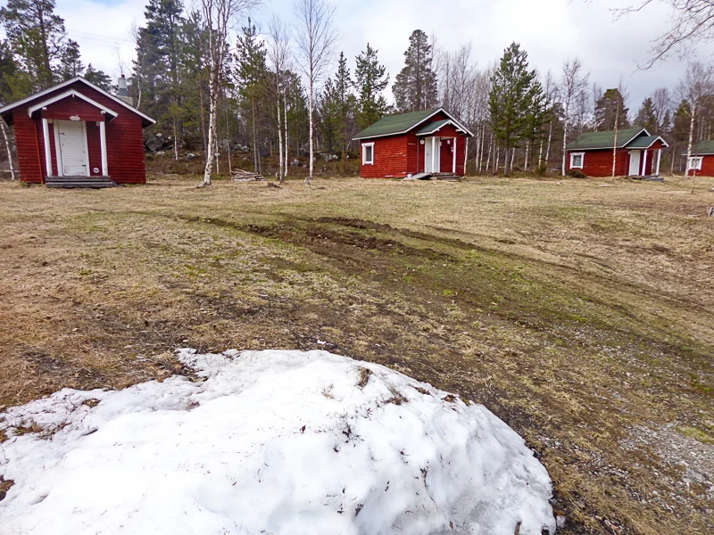
We were only a short distance into Finland and out in the woods when it was time for lunch.  We had not passed much in the way of civilization, so I was curious about lunch.  We stopped at a campground and a wonderful couple made us some lunch.  This couple were the proprietors of the campground.  You can see some of the small cabins in the campground in the first photo.  There was also still snow on the ground.

181-DSC02571.jpg

You can see Vicky giving the wife a hug in her kitchen in the second photo.  It was a simple, hands-on operation.  We didn’t see any other customers.

182-DSC02586.jpg

The third photo is part of the food line.  The fish was white fish that the husband had caught and smoked.  The breads were fresh baked, the salads were fresh and very good, and there was cheese and yogurt to add to the dishes.

183-DSC02579.jpg

My plate is in the fourth photo.  The meatballs are reindeer meatballs.  They were tasty and actually very much like beef.   

184-DSC02582.jpg

The last photo is right behind the building where we ate lunch.  This lake is part of their campground.  They had other facilities as well.

185-DSC02575.jpg

Hotel Ivalo

We stayed at the Hotel Ivalo in the town of Ivalo.  It’s a family owned business.  They just lock the front door at night and go to bed.  But we stayed here two nights and were very comfortable.  You can see the hotel in the first photo.  I put this photo in to show that one highlight is that they have a neon thermometer on the outside of the hotel.  And yes, it was Zero Degrees, which is Celsius, so 32 degrees Fahrenheit.  This was at some point in the morning.   

186-DSC02614.jpg

Vicky and I enjoyed the rocking chairs in front of the fireplace in the second photo.  The dining room is behind and the bar is to the right, behind the fireplace.  It was a nice place to sit and relax.

187-DSC02603.jpg

We ate dinner next door to the hotel the first night.  The restaurant is a separate building but I think that it is a part of the Hotel Ivalo.  You can see it in the third photo.

188-DSC02612.jpg

Pete (Vicky’s brother) and Nora were eating with us and you can see them and the inside of the restaurant in the fourth photo.  It was warm and cozy as you will notice that we are drinking cold beer with dinner.

189-DSC02605.jpg

Dinner was a very good mushroom soup, reindeer meat over potatoes, salads, Karhu beers, and an apple cake with fresh cream for dessert.

The hotel actually had some amenities, such as Saunas.  Saunas are an important Finnish tradition.  We saw saunas everywhere we went.  They had both a men’s sauna and a woman’s sauna.  Tradition is that you take a sauna naked, so no photos.  For me, the sauna was way too hot, but that’s how they like it.  But I couldn’t resist a photo of Vicky and Nora on their swing on the bank of the Ivalo River. 

190-DSC02610.jpg

Ivalo

Ivalo is a small town with a population of around 4,000 but it passes for a big town in this part of the world.  They even have an airport, probably the farthest northern airport in the EU.  I walked Ivalo each morning and once in the afternoon.  There wasn’t a lot to see but I thought I would include a post anyway.  Each time I walked the town, I passed a dozen or so people.  No one ever spoke to me.  The Finns are evidently a quiet people and don’t make small talk.  The town was pretty much destroyed by the retreating German troops in 1944-1945 but they have rebuilt it.

Ivalo does get tourists though.  In winter, the area has downhill and cross-country skiing, snowboarding, husky and reindeer sled rides, ice fishing, and northern lights sighting.  In summer they have hiking and trekking, canoeing, fishing, mountain biking, gold panning, and more.

The busiest place in town from my little experience was what you can see in the first photo.  Ivalo must be a huge boating community.  I’m not sure what the smoke stack in the background is for but probably some industry.

191-DSC02716.jpg

The church in the second photo just seemed like a good representative photo for Ivalo.  It looked pretty simple but nice.

192-DSC02714.jpg

With not much to see on the main street, I veered off into some small, quiet neighborhoods along the Ivalo River.  You can see one in the third photo.  How quiet was it?  Check out the giant rabbit crossing the street in the back of the road.  It was huge.

193-DSC02713.jpg

I saw a school on one walk and went in to check it out.  The highlight was the football (soccer) field which you can see in the fourth photo.  I wasn’t too surprised by the fake turf, with all long cold snowy winters that they have in Ivalo.

194-DSC02679.jpg

But as I walked down the field, I finally noticed the basketball hoop mounted above the soccer goal.  Now that was a new one for me.  It was a combination soccer and basketball field, something you don’t see every day.

195-DSC02680.jpg

If the NBA ever gets a player from Ivalo, we’ll know where he started out.