Antarctic Peninsula

We left Andvord Bay and cruised south along the Antarctic Peninsula.  We didn’t see as many icebergs as on the way into the Andvord Bay, but we saw some bigger icebergs.  It was actually a bit of a dark and bleak day at this point in late afternoon when the sun came out somewhat low to the horizon.  I went out on deck and took these photos.  I liked the dark day with the icebergs in the direct sunlight.

In the first photo, you can see a string of icebergs across the water.  The next two photos are as we got closer to the icebergs.

Approaching Icebergs

It was interesting approaching icebergs.  In the wide open spaces of the Antarctic, it was somewhat difficult to determine just how big the icebergs were.  This was one of the earliest large icebergs that we came across (though not large by later iceberg standards).  I have included three photos of it.  If you notice in the first photo, the front of our ship is aimed right for it.  I thought that odd at the time, but it turned out to be relatively normal for our ship.  The captain liked to give us a close up view of icebergs, glaciers, whales, and everything else.  In the second photo, you can see that we have gotten much closer to this iceberg.  This is not from my zooming in with my camera lens.  In the third photo, I’m on the seventh deck in full back lens (non-zoom) and you can see how much of the berg is in the photo.  I’m not saying that we were too close, but with the wind behind me, I’m sure I could have spit on this iceberg.

App Bergs 1.jpg

Shipboard Amenities

This was an “expedition cruise” and not an “entertainment cruise”.  At least, that’s what our ship’s crew told us.  We had two or three lectures a day and no entertainment at night.  But the ship was not without any amenities.  The bar was always open and there was always food available.  We managed to exercise some moderation with our drinking or eating, but after all, we were in the Antarctic.

The first two photos go together.  I told you that the bar served iceberg ice with the drinks for several days when we were in the Antarctic.  You can see the bar’s advertisement in the first photo and Vicky and myself enjoying a drink with iceberg ice in the second photo.  Also in the second photo, you can see the people behind us sitting and looking out the windows.  This was the “warmer” option available for those who didn’t want to stand out on the ship’s deck, facing the wind and cold, just to get some better photos and memories.

The third photo is Vicky and our long-time travel companions, Ron and Patty, getting ready to enjoy a meal in the dining room.  You can see the Almirante Brown station and some icebergs out the window.

Almirante Brown

This was our next shore excursion.  It was an Argentine research station named Almirante Brown.  In 1984, the station’s doctor went mad (too much time in Antarctica, I suppose) and burned down the station.  It’s been partially rebuilt, but not reopened.  This place is also on the Antarctic Peninsula.  It’s near Skontrop Cove and in Paradise Harbor.  We saw gentoo penguins, skuas, cormorant nesting areas, and other birds here as well.

These photos are all view photos of the station, the harbor and the cove.  The first and third photos were taken from the top of the peak where we hiked.  Just to the right of my knee in the first photo, the smaller red building is where our small boats landed us to come ashore.  You can see plenty of active glaciers in this cove.

The second photo was taken lower down the hill.  It was an overcast day but it still seemed very bright with all the snow and ice. 

The third photo is again, farther up the hill and more to the left of the first photo.

Vicky tackles Almirante Brown

We had our usual one hour ashore here at the Almirante Brown station.  The walk up the hill was steep and a fair distance.  You can see the top of the hill from behind the red buildings (prior email) in the first photo.  The people on top of the hill look small because it was a ways up.  It was also very steep.

Vicky told me to go ahead up the hill that she was going to just stay at the bottom and watch the penguins.  I said okay and started up by myself.  I stopped to catch my breath about a third of the way up.  When I turned around to look back, Vicky was coming up the hill with a full head of steam.  I waited for her to reach me and asked her how come she changed her mind about climbing up the mountain.  She said that she wasn’t going to until a couple of 85 year old women passed her up saying it would be an easy climb.  You can see Vicky in the second photo, having reached the top at record speed.

The snow on the mountain here at Almirante Brown was rather icy and hard compared to the other glaciers and mountains we hiked in Antarctica.  It really did take us a good thirty minutes to get up to the top and enjoy a few minutes  up there and to take the photos that you have seen in the last two emails.  So when it was time to go back down, I was both looking at my watch and thinking about how hard it was going to be going down hill on the hard frozen ice.  Near the trail, there was a bare-butt toboggan run.  We talked it over and said “why not”.  Vicky and I came down the mountain in a few seconds, leaving us plenty of time to watch the penguins.  You can see Vicky at the bottom of her slide in the third photo.


Lemaire Channel

We are still heading south on the west side of the Antarctic Peninsula at this point in time.  After lunch this day, we entered the Lemaire Channel.  This channel was first sighted by explorers in 1873 and first charted and traversed in 1898.  The channel is seven miles long and one mile wide.  The weather was bad when we got here and kept getting worse as we made our way through the channel.

You can see the entry way to the Lemaire Channel in the first photo.  It looked a bit ominous to me, but I wasn’t driving the ship, so we went ahead and entered the channel.  But with all the icebergs blocking the channel, I was on deck and keeping a sharp eye. 

Lemaire Channel was filled with icebergs and you can see why in the second photo.  This second photo is the side of the channel and it’s solid glaciers that look to be calving with regularity.  Our ship had to nudge its way through the ice and we could hear loud collision noises frequently as we hit these smaller icebergs.

The third photo was one of the more interesting looking icebergs in the channel.  It’s a glacial iceberg that got top-heavy and rolled over.  I was also impressed by how blue some of these bergs looked even under very grey weather conditions.  You can also notice the front of our ship and see that we are not missing this iceberg by very much at all.


65 Degrees, 27 Minutes south latitude

One of our goals on our trip to Antarctica was to get within the Antarctic Circle.  The Antarctic Circle marks a line where there is at least one day a year of total light and also at least one day of total darkness.  The farther south you go, the more days of total light and dark a year.  At the South Pole, the sun comes up once a year and the sun sets once a year.  There is a similar situation at the North Pole.

Our ship’s crew also expressed a goal of reaching the Antarctic Circle and we knew that we were getting close at this point of our trip.  The circle line is at something like 66 degrees and 30 minutes south latitude.

As we came out the other end of the Lemaire Channel, we ran into a blizzard.  It was snowing and blowing and visibility was very low.  The captain made the decision that we had to turn around and go back north.  Our most southern point was 65 degrees 27 minutes south latitude.  These pictures were taken at that point, but with very low visibility.  I would add the reminder that this is at the end of summer in the Antarctic, like the equivalent of August where we live.

This picture is the side of the channel.  It’s the bottom of a glacier, but I loved the curving, swirling ice.  The blue stood out more to my eyes at the time, but again, this was in some weather.

The second picture I took from behind the ship because it was so hard getting a picture into the wind and snow from the front of the ship.  You can see all the ice and small icebergs in the water which we were hitting regularly as we moved through this area.

The third photo I also took looking back.  At this point, we couldn’t see the water.  The whole sea was solid icebergs, snow and ice.  We just plowed our way through it dodging the big ones.

It was the Antarctic Circle or Bust run - - and we busted, though we did get within one degree of the Circle.

Antarctic Shopping

One thing I want to point out is that the Antarctic is a very expensive trip.  It’s by far the most expensive trip that we have taken so far and we’ve been to some faraway places for some long vacations.  I did, however, see one bright side to this trip.  I did a bit of research before we left and learned that Antarctica has no towns, no houses, no roads, no hotels, etc.  To me, that meant “No Shopping” opportunities.  I figured that while it was an expensive trip, at least Vicky wouldn’t have any opportunities to add to my discomfort through shopping.

In that regard, Antarctica turned out to be like the U.S. tax code, there is an exception to Everything!

Port Lockroy was the shopping exception in the Antarctic.  This was our next land excursion but we were told in advance that there really wasn’t much to see or do at Port Lockroy, except for a chance to buy a souvenir and get our passport stamped with Antarctica.

Still, the first picture was taken off the bow of our ship and as you can see, Goudier Island is small and the weather was blizzard conditions.  I mean, honestly, WHO would take a small boat through all that snow and ice simply for the chance to buy a shirt and trinket?

See below for the answer to that question.

In the third photo, you can see that Vicky was successful.  Port Lockroy was originally a base set up by the British in 1941 as part of their war effort.  It was later closed down.  It has now been reopened as a museum by the Antarctic Heritage Trust.  It’s been restored to the way it was in the 1950s.  It has a communications room, kitchen, sleeping quarters, and they added a post office and souvenir shop.  I won’t include any of the other rooms in photos but that’s why you see the painting of ‘Marilyn’ on the wall in the third photo.  Of course, Vicky thinks that Marilyn was the real reason I took this photo but I assured her, I was only recording her purchase.


Port Lockroy

I figured that as long as I had to go to Port Lockroy to pay for Vicky’s shopping, I may as well poke around and take a few pictures of the penguins.  The weather was blowing snow and grim when we arrived and it didn’t get any better.  The penguins didn’t seem to mind the blowing snow but it was difficult to get much in the way of pictures.  These three don’t need much explanation.

Port L 1.jpg

Errera Channel

This is the next day and we were heading north now, but still on the west side of the Antarctic Peninsula.  We had passed through the Errera Channel on our way down, but the weather was so bad, I didn’t get any good pictures.  This channel had some pretty large icebergs in it and was quite beautiful.  We ended up anchoring off the southern part of the channel and going ashore.

These photos were taken from shore, but all are looking at the Errera Channel.  It was not that wide a channel, so you can imagine that the trip through was fun and exciting.  I don’t think the photos need any further explanation.


Danco Island

This was our next Antarctic landing which was on Danco Island, just off the west coast of the Antarctic Peninsula.  It’s a small island with an abandoned British survey hut.  All that’s left are a couple of small foundations.  Danco Island is the home to a large gentoo penguin rookery.  Other birds included skuas, sheathbills, and Antarctic gulls.

We hiked up another glacial mountain on Danco Island which you can see in this photo.  The sun came and went while we were here, but the wind never ceased.  Gentoo penguins were all about on the island.  They were nesting from shore to the mountain tops. 

The second photo is up the hill a ways and you can see a skua in flight over a bunch of penguins.  The skuas regularly patrol the penguin colonies looking for a meal, whether it’s an egg or a young penguin.

The third photo is another shot of some penguin highways.  Danco penguin highways were probably the equivalent of L.A. highways.


Baby Penguins

Danco Island had a really big population of gentoo penguins.  We spent most of our time on Danco watching the penguins.  I’m going to send out two emails with baby penguin photos – and believe me, I’m limiting myself with only two.  I managed to learn how to speak ‘Gentooese’ while in Antarctica so I’ll give you the photo and then tell you what the babies were saying in “Gentoo.”

"Dude, three weeks, no bath.  Awesome!”

Babies 1.jpg

“I’ve been pumping Krill.”

“Why do we have to learn to pick up rocks?”

Hitchhikers

In the afternoon, after Danco Island, we cruised into Wilhelmina Bay which is a large bay on the Antarctic Peninsula.  The whole bay is surrounded by high mountains and high glacier walls.  There were hundreds of icebergs in the bay and we had a 360 degree beautiful view.  The weather and the sun came and went but the whole time here was great.

One common sight was hitchhikers on the icebergs.  Most of the time, they seemed oblivious to us until we got close to them.  At that point, they usually jumped off and went for a swim.  Icebergs give them a resting place where they won’t get eaten by an Orca.  These photos are a sequence of an iceberg with a few hitchhikers on it in Wilhelmina Bay.

Hitch 2.jpg


Fur Seals

We are still in Wilhelmina Bay.  This is just a photo sequence of some fur seals at rest on an iceberg, at least until we came along.

The pictures should be self explanatory with one exception.  None of the fur seals are hurt or bleeding.  The red coloration that you see is actually their own crap.  Fur seals, whales, penguins, fish, and most everything else down there primarily live on a diet of krill.  Krill is shrimp and krill is a reddish color, so of course their scat is also that reddish color.

Brown Bluff

We awoke this morning to a foggy day and freezing temperature.  We were near the end of the Tabarin Peninsula.  We have been going north and we are also now very near the Antarctic Sound which is at the northern end of the Antarctic Peninsula.

We were scheduled for an 8:00am landing at Brown Bluff.  It has a 2450 foot cliff right up against the Sound.  Brown Bluff is the home to some 500,000 Adelie penguins as well as gentoo penguins, cape petrels, kelp gulls, and leopard seals.

I started to have some doubts about our trip into Brown Bluff.  I was standing out on deck as we approached it.  These photos were all taken about the same time as I walked around the fifth deck.

This first photo was taken off the back of the ship.  Our ship made the open water that you see in the photo but you can also see that the sea and ice are closing right back together after our passage.

This next photo was taken off the side of the ship but that’s what the whole ocean looked like that we were moving through at the time.

This third photo was taken off the front of the ship and as you can see, the icebergs up ahead were getting bigger.

Brown Bluff - Bust

We had 8 scheduled land excursions in the Antarctic and we made seven of them, which was remarkable.  The only time that we didn’t make it to shore was at Brown Bluff.  These photos will give you a good understanding of why we didn’t make it to shore this time.

This first photo was taken off the bow of the ship.  When I walked up to the front of the ship and saw where we were headed, I thought the captain must be crazy.  Why on earth would he steer us between those icebergs in the photo?

Brown B 4.jpg

The next two photos will tell you why.  It only looked worse off to both sides – and the bergs just kept getting bigger.  So the captain said Brown Bluff was a bust and I had no argument with that decision at all.


The Captain's Bridge

When our trip ashore to Brown Bluff got cancelled, the crew added a visit to the ship’s Bridge to take its place.  I would have preferred to go to Brown Bluff, but at least we had another event to take its place.  The bridge and the captain are the nerve center of the ship.

The highlight of the bridge visit was a conversation between a quite elderly woman passenger and the captain.  It went like this:

Passenger: How do you tell where the icebergs are so you don’t hit them?

Captain: We watch for them.

Passenger: NO, I mean how do you tell exactly where they are?

Captain: We just look.

Passenger: With what?

Captain: Our eyes.  We just use our eyesight.

Passenger (looking extremely alarmed): But you must use sonar or radar or GPS or something to be able to know where they are?

Captain: No, just our eyesight.  We do use binoculars sometimes of course.

Passenger: You must use more than just eyesight.  What do you do at night?

Captain: We have three spotlights on the ship that we shine out to see where the icebergs are at night.

Passenger (looking exponentially more alarmed – as were we all): That just can’t be right.  You mean you don’t have any radar or sonar or satellite photos or anything?

Captain: The only thing like that we use is satellite photos.  But in Antarctica, it’s frequently overcast for weeks at a time, so our satellite photos might be two weeks old.  Of course, the really big icebergs move very slowly so satellite photos still give us some idea of them being in the vicinity, just not exactly where they show on the dated satellite screen.

Passenger: (looking ready to keel over): But Captain, what about at night in a big storm and blizzard conditions like we’ve experienced?

Captain: We just use more eyes.

Passenger: What do you mean?

Captain: I bring more crew members up to the bridge so I have more people watching for icebergs in really bad conditions.


My personal thought at that point was no wonder a ship sank down here two months ago and our ship pulled the people out of the water.

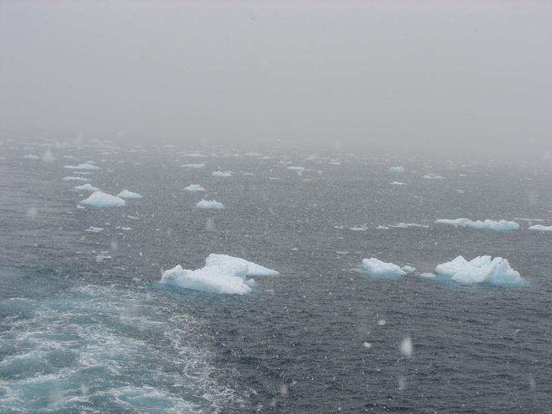
This photo is the captain on the bridge.  You can see our view of the ocean and icebergs right behind him.  (Very clear view, right?)

This photo is the satellite screen on the bridge.  The yellow dots are the big icebergs, the white dots are smaller icebergs, etc.

Also, the captain added that we hadn’t seen any really large icebergs yet on this trip.  He said they did see one two weeks ago that was 32 miles long.  He also said that we still weren’t to the area where the really big icebergs are generally located.

 ANTARCTIC QUIZ.

Here’s a quiz question for you.  After learning that the only way our ship was avoiding hitting icebergs was by our ship’s crew “keeping a sharp eye”, Vicky and I promptly did which of the following?

A.      Went to the 7th deck bar and ordered a round of Harvey Wallbanger cocktails.

B.      Went below, got our binoculars and went to the front of the 5th deck to help the crew to “keep a sharp eye out”.

C.      Said to heck with it all and went to the back of the 6th deck and went hot tubbing.

Antarctic Sound

The Antarctic Sound is a passageway between the end of the Antarctic Peninsula and Joinville Island.  We were going from the west side of the Antarctic Peninsula to the east side of it.  The Antarctic Sound is 30 miles long.  Our ship’s crew said it was doubtful that we would be able to get all the way through it, due to all the icebergs, but that they were going to make the attempt.

 For my part, I was really hoping to make it all the way through the Sound.  The Weddell Sea was on the other side of the Sound and I really wanted to make it to the Weddell Sea.  The Weddell Sea is where Ernest Shackleton on his exploratory journey aboard the ship Endurance spent some two years.  The got stuck in the ice in the Weddell Sea and the ice crushed their ship.  It took them two years to get back to civilization.  Shackleton wrote about his journey in the book “South”.  The book was a hard read but well worth it to learn about the Antarctic.  My daughter, Cory, gave me the book for Christmas and Vicky and I read it right before our trip down here.  I highly recommend the book if anyone is interested.  There are also other books about the Endurance expedition in 1914. 

These photos are as we were first getting into the Antarctic Sound.  These are glacial icebergs.  Notice around and behind the main icebergs in the photos and you will see that the whole Sound was littered with icebergs.


Iceberg Alley

We are still in the Antarctic Sound.  Our ship’s crew called the Antarctic Sound “iceberg alley”.  It was not hard to see why.  The Sound was loaded with icebergs of all sizes.  The farther we got into the Sound, and the closer we got to the other end and the Weddell Sea, the more we saw of the larger tabular icebergs.  Tabular icebergs do not come from glaciers, but rather come from the “ice shelves” of the Weddell Sea and Ross Sea.  These seas are frozen over solid but occasionally, large chunks of the ice shelf break off to become icebergs.  The tabular icebergs are the really big icebergs.

These photos are different tabular icebergs that we saw on our trip through the Antarctic Sound.

Ant S 4.jpg