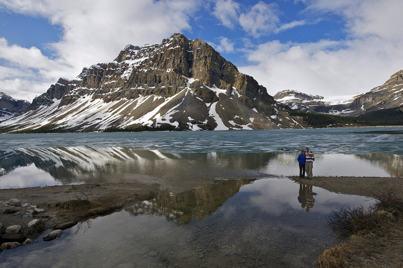
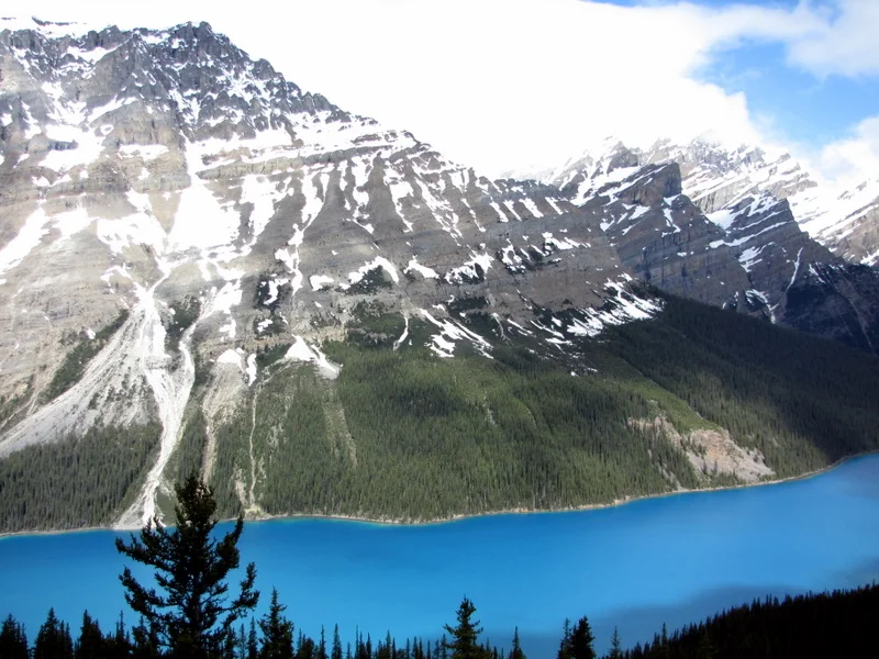
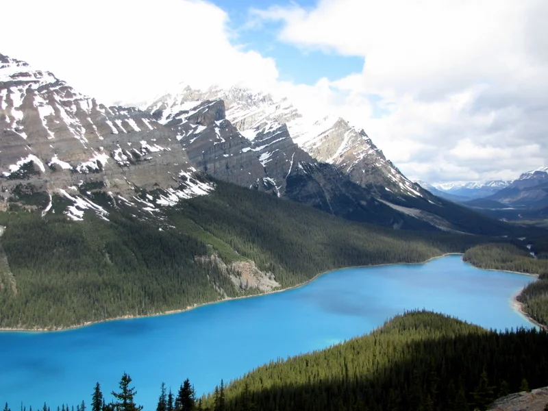
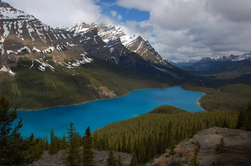
Bow Lake and Glacier

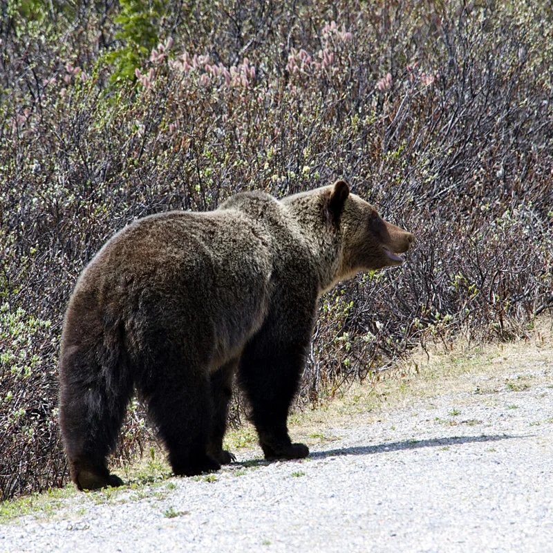
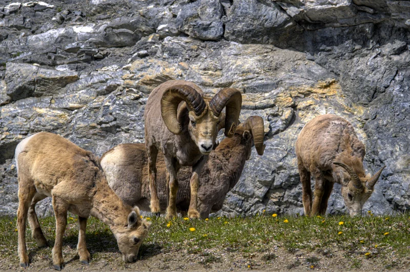
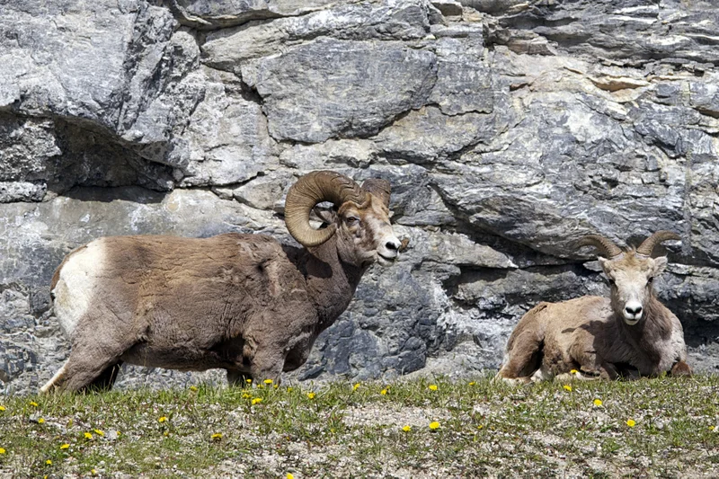
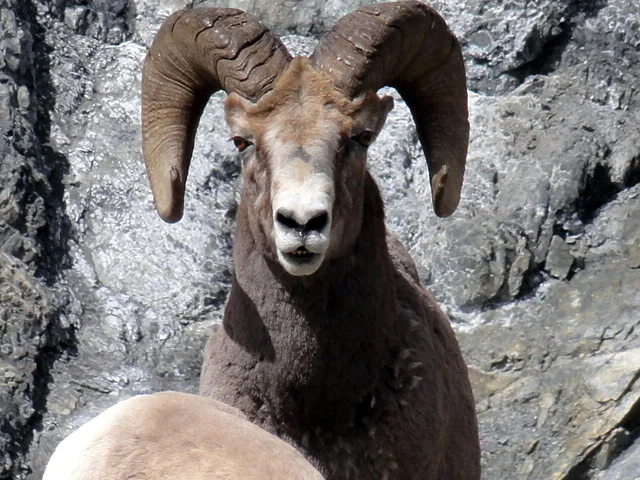
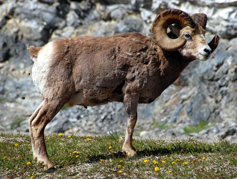
We were up and out early today to drive “The Icefields Parkway” in Banff and Jasper National Parks from Lake Louise to the town of Jasper.  The weather was a constantly changing mix of clouds, sun, and rain with hot, then cold and windy, then calm and mixes of all of these.  It seemed like we were driving along side of a beautiful river the whole day with lush forests and snow-capped peaks all around us.  We also saw plenty of wildlife, though not in the quantities seen earlier in the trip.  We spent the whole day driving north on Hwy 93.

One of our earlier stops was at Bow Lake and Bow Glacier.  The lake and glacier captured a lot of the great things about the Icefields Parkway.  I’ve included four photos of the lake and glacier above it.  The colors, textures, mountains, clouds, and reflections were all very dramatic and beautiful.


Peyto Lake

We are still on the Icefields Parkway and not too far along the road from Bow Lake, we stopped at the trail head for Peyto Lake.  It was named after Bill Peyto (Pr. Pee-toe) who was a colorful character from the frontier days.  It was raining and we debated taking the short hike to see the lake.  After all, we had already seen so many beautiful lakes.  But we all hated the thought of missing something, so we put on our coats and hats and started hiking. 

I’ve included four photos of Peyto Lake.  Even after seeing all the lakes up to this point, the turquoise color of Peyto Lake astounded me.  It almost seemed like it was lighted from below the water.  We spent some serious standing and observing time looking at Peyto Lake.  It was one of the highlights of the day for me.  There was also a string of small lakes below Peyto Lake that had the same color.  You can see them in the second and third photo below and to the right of the lake.  These photos don’t show the color of the small lakes because they were in the shade of a cloud at the time but it was the same brilliant color as Peyto Lake.  I’m glad we took the short hike in the rain to see it.

North Saskatchewan River

We are still driving north on the Icefields Parkway, and still stopping at every lake, falls, trail, and turnout.  The rivers were beautiful and had cut through rock in many places, so they were like a bunch of miniature Grand Canyons, only twisting with lots of exposed layers of rock and huge amounts of water flowing down them.  You can see two such places along the North Saskatchewan River in the first two photos.  Andrew (photo 1) and me (photo 2) might look like we are being daring but we weren’t.  We did see, however, a bunch of people who needed their heads examined, based on places they were standing and things they were doing.  We saw far too many of these places to show in my emails plus it was hard to capture in photos all the depths and falls and excitement of these places.

A bit farther along but still on the North Saskatchewan River, we saw a black bear near the road and along the river.  You can see this bear in the third photo.  I love our photos of this with the beautiful water, the varied trees, the grasses, rocks, and dandelions.  The bear was eating the dandelions and there was no shortage of them.  I always get inquiries about how close were we to the bears.  In this case, we were about 10 feet from the bear at one point.  You can get a better idea from the last photo.


Icefields Parkway Grizzly

We are still on the Icefields Parkway and about four or five stops past the last stop with the black bear.  We had just pulled back onto the highway from viewing Parker’s Ridge when we saw lots of cars and people along the highway.  Seeing the direction of their movement, I pulled past them and maneuvered our RV in amongst the other vehicles.  It was a Grizzly bear and he was heading right for us.  The Grizzly came within 10 – 12 feet of us – and we stayed inside our RV.  After coming right to our RV, he went off the roadway, but only another 10 – 15 feet.  He was rooting around a small mound covered with brush.  Then he partially stood up and then crouched (4th photo) in place.  We had no idea what he was doing and we were speculating about it.  I was guessing that nature was about to take its course.  Suddenly, a squirrel ran out from the mound under the bear.  The squirrel ran as fast as it could and was zigzagging as it went.  The Grizzly bear was after it and only about a nose from the squirrel the entire run, making every turn that the squirrel made.  The squirrel made it to another hole without the bear catching it, but it was a close race.

The visitor center had information on Grizzly bears.  It said that in a sprint, a Grizzly is about 150% faster than an Olympic sprinter.  I didn’t believe it when I read it.  I believe it now, after I saw this Grizzly chase a squirrel.  Watching the Grizzly chase the squirrel was the highlight of the day for me.  It would have made a great video, but none of us ever expected to see what we ended up witnessing.

About 25 to 30 idiots were standing outside their vehicles and right along the road as the squirrel chase was happening.  Even after the bear gave up on the squirrel and started walking back in our direction, they were all still standing outside taking photos.  And some of you might have thought that we were crazy.  Well, we weren’t that crazy.  We started to speculate about whether “natural selection” might take place, since the Grizzly hadn’t caught the squirrel.  But the bear wandered off in search of other ‘natural’ food.


Athabasca Glacier

We crossed Sunwapta Pass and entered Jasper National Park.  Shortly after, we stopped at the Icefield Centre.  We visited the Athabasca Glacier.  It was not as exciting for Vicky and me since we were in Antarctica just a couple of years ago and did plenty of cavorting on glaciers.  But it was still fun.  The first photo is the Athabasca Glacier from the Icefield Centre building.  You can see it more zoomed in by looking at the second photo.  In both photos, you can see the Ice Explorer vehicles going to or from the toe of the glacier.  The Ice Explorer vehicle climbs up and down a 32% grade to get there and back. 

 In the third photo, you can see Vicky and myself standing at the glacier’s toe.  We drank glacial melt, took photos, and cavorted around the glacier.  And in case you are curious to know just how big those Ice Explorer vehicles are – which looked so small in the first two photos, you can see April standing by ours in the last photo.

Big Horn Sheep

Shortly after we passed the Icefield Centre and the Athabasca Glacier, we came upon two separate groups of Big Horn sheep.  There were six or seven sheep in each group.  We didn’t get that many great shots of the Big Horns and I thought these were pretty good, so here’s four of our photos of Big Horn sheep – grazing the dandelions.

Jasper National Park Falls

We saw plenty of waterfalls in Jasper National Park on our way to Jasper and Whistlers Campground.  The first photo was at Tangle Falls.  The second photo was at Sunwapta Falls.  The third photo was at Athabasca Falls.  The final photo was also at Athabasca Falls but this was an older canyon and the river has diverted itself into a new canyon, so the park service made this canyon into a walkway to get to the lower falls area. 

Mount Edith Cavell

We were surprised to find that many parks, campgrounds, and other features up in the Canadian Rockies don’t open until the second half of June.  The weather that far north makes it silly to open any earlier.  So as we drove along Scenic Highway 93A on this day, we just happened upon the first day opening of the road to Mount Edith Cavell.  They had paved the road before they opened so we were one of the first vehicles to drive up the new road.  It was very steep and winding but very smooth.

 It looked interesting from the parking lot, but we found our hike to far exceed our expectations.  Mount Edith Cavell has three glaciers on it: the Cavell, Angel, and Ghost Glaciers.  We expected this to be a short hike but we ended up spending over two hours hiking.  As you can see from the photos, the combination of rock, snow, water, glaciers, and avalanche debris including rocks and ice boulders made for an interesting landscape.  The first photo will give you the best idea of where we spent the bulk of our two hours. 

181-BOZ8230Compressor.jpg

If you see the ice boulder to the right of the lake in the first photo, Vicky and I are standing in front of it in the second photo – to give you a size perspective.  By this time, we were well aware that boulders such as this one had arrived at their current location by avalanche.  We could also hear very frequent avalanche noises but despite hearing them with a high frequency, we never saw one at this location.  I guess they were happening on the other side of the mountains and we could just hear them.

This place just seemed to have a magical look and feel.  Vicky seemed ready to move on but Andrew, April and I had trouble prying ourselves away from it.


Jasper Wildlife

We also saw plenty of wildlife up in the Jasper area.  I’ve included a few of the good wildlife shots from there.  They are: 1. A black bear along the road; 2. A bald eagle, 3. A young moose (another great wildlife photo by April, catching the young moose with his tongue hanging out); and some moldy looking female Big Horn sheep.

Mt Rainier National Park

Heavy rain caught up to us again in Jasper and we headed back towards home a day early.  We did our best to drink up our Appleton Rum and Baily’s Irish Cream plus eat all of our chocolate before we hit the U.S. border.  The border guard didn’t take anything from us be he asked an awful lot of questions.  At some point, he looked us up and down real good, and I suspect he smelled us, and determined that we really had been camping, and he said welcome back and told us to drive on.

We drove south on Hwy 5 and never saw the sun until Seattle, and then not for long.  Our destination was Mount Rainier National Park.  We arrived, drove around the park, went to the visitor center, did several hikes and off and on, we caught some nice glimpses of Mount Rainier.  You can see a good photo of Mt Rainier in the first photo.  The second photo was a more typical view.  We did plenty of stopping such as in the third photo.  You can see Vicky and me on the road above the falls.  The higher ground in the park was snow covered such as in the second photo and we saw people skiing down the hills.  But lower ground was spring like, such as in the last photo.

More Mt Rainier NP

One of our two hikes in Mt Rainer National Park was along the Paradise River up to Carter Falls and Madcap Falls.  The first photo was the start of that hike, though that is not the Paradise River.  Andrew spent quite a bit of time including late into the night taking photos at Mt Rainier.  I’m just including two of them here that I really enjoyed.

195-BOZ8550Enhancer.jpg

Mount Rainier Wildlife

We got to see plenty of wildlife in Mt Rainier National Park.  We mostly saw deer, fox, and birds.  The first photo is a fox.  I’m not sure which one this is but I think there are three kinds of foxes in the park.  This guy didn’t seem to enjoy having to make his way through the deep snow.  The second photo is a ptarmigan which I spotted just off the road while I was driving.  The next two photos are of our favorite animal sited in the park and the one we saw the most of, the Washington Cascade Red Fox.  Most of the animals that we saw were along the road and we were able to get very close to them.

197-BOZ8447Enhancer.jpg

Flowers

Vicky took the first photo and she posted it on her Facebook page.  In her photo, I was taking a photo of a tiny orchid (the third flower photo).  Since then, several people have asked me why I haven’t posted any flower photos from our trip.  I just figured that everyone would be more interested in the animal photos.  I did take a few nice photos of small orchids and other small flowers.  We were too early for most of the massive spring flower patches but we did see plenty of flowers.  I had to get down and dirty to get many of them, including a few that I took in the rain.   I’ve included four of my flower photos.

THE END

Well, you knew this trip had to end sometime.  After over 50 posts and over 200 photos, this is the end of the Great Rocky Mountains Grizzly Bear Adventure.  I’ve included a few finishing photos for the final post.  I get asked quite a bit about “how” I remember everything that I write in my posts.  Well, other than the parts that I just plain make up, I take notes during the day and usually write in my journal every night.  I mostly remember what we did each day but it’s too hard to try and remember every detail, especially the names of all the waterfalls and lakes and animals and highways and so on, so I take notes.  You can see me jotting down some notes in the first photo, taken in Glacier Park Lodge (while the girls went shopping).

I’ve had quite a few questions about how we traveled.  I’ve included a lunch photo of us in front of our little RV that Andrew rented for us.  We were eating lunch overlooking the East fork of the Bitterroot River in Idaho.  This was a pretty typical lunch for us: some lunchmeat, cheese, peanut butter, celery, carrots, almonds, and pita bread.  All four of us took turns driving the RV, though I drove it the most.  Vicky and I slept inside the RV while Andrew and April slept outside in their tent.  All in all, it worked out quite well.

Someone told me that I said we saw plenty of deer, but I didn’t send out any deer photos.  That’s because we see them every day at our house and they’re a major pest.  They love to eat our grapes, roses, vegetables and most everything else.  Personally, I consider them an ally of the gopher.  But I will throw in one deer photo (photo 3), just to prove that we saw one.  Andrew did a great job of catching this deer in mid air.  This was along the Bow Valley Parkway.

You might remember from one of the first posts that we nicknamed our RV – Donner.  That was my suggestion because we spent the first night at Donner Lake and then Vicky decided our RV needed a name.  Well, when we were driving the Ice Fields Parkway, I managed to snag a dragon fly on our antenna.  He stayed right there for over a hundred miles, through rain, wind, dust and pestilence.  Andrew decided that the dragon fly was our trip mascot and that his name was Donner.  Andrew took this photo of Donner at about 65 miles-an-hour as we cruised along the parkway (photo 4).

And now let’s face it, when I’m down to sending out mashed-on-the-car-antenna insect photos, the trip has reached the end of the line and deserves to be escorted into the sunset….

 THE END