Akhal-Teke Horse Farm

This is east of Ashgabat on a visit to an Akhal-Teke horse farm.  The Akhal-Teke is a horse breed from Turkmenistan and the country’s national emblem.  This horse breed goes back about 3,000 years with earliest mentions as far back as the fourth or third centuries B.C.  Alexander the Great’s favorite horse was an Akhal-Teke.  Akhal was the name of the line of oases along the north slope of the Kopet Dag mountains which were inhabited by the Tekke tribe of Turkomans. 

The Akhal-Teke were developed by the fierce nomadic warriors of Central Asia and have a reputation for speed, endurance, agility, and a distinctive metallic sheen.  They are adapted to severe climatic conditions.  They are renowned as race horses with a reputation for great stamina and courage.  Currently, Akhal-Teke horses in Turkmenistan are not allowed to leave Turkmenistan. 

You can see a small part of their main corral in the  first photo.  This horse farm currently has 92 Akhal-Teke horses.  The owner raises them for racing and for sale.  You can see the Kara Kum Desert in the background.

DSC04132.JPG

We had a long “horse showing” during our visit.  I don’t remember how many horses were brought out, but it was quite a few.  Vicky enjoyed the horse showing as you can see in the second photo.

DSC04143.JPG

To say that some of the horses were spirited would be an understatement, such as the horse in the third photo.  He evidently wasn’t interested in our horse showing.

DSC04175.JPG

I’m with the owner of the farm in the fourth photo.  He seemed to love his farm and horses.  He is a friend of Turkmenistan’s President and has a big photo of the two of them in their dining room.

DSC04173.JPG

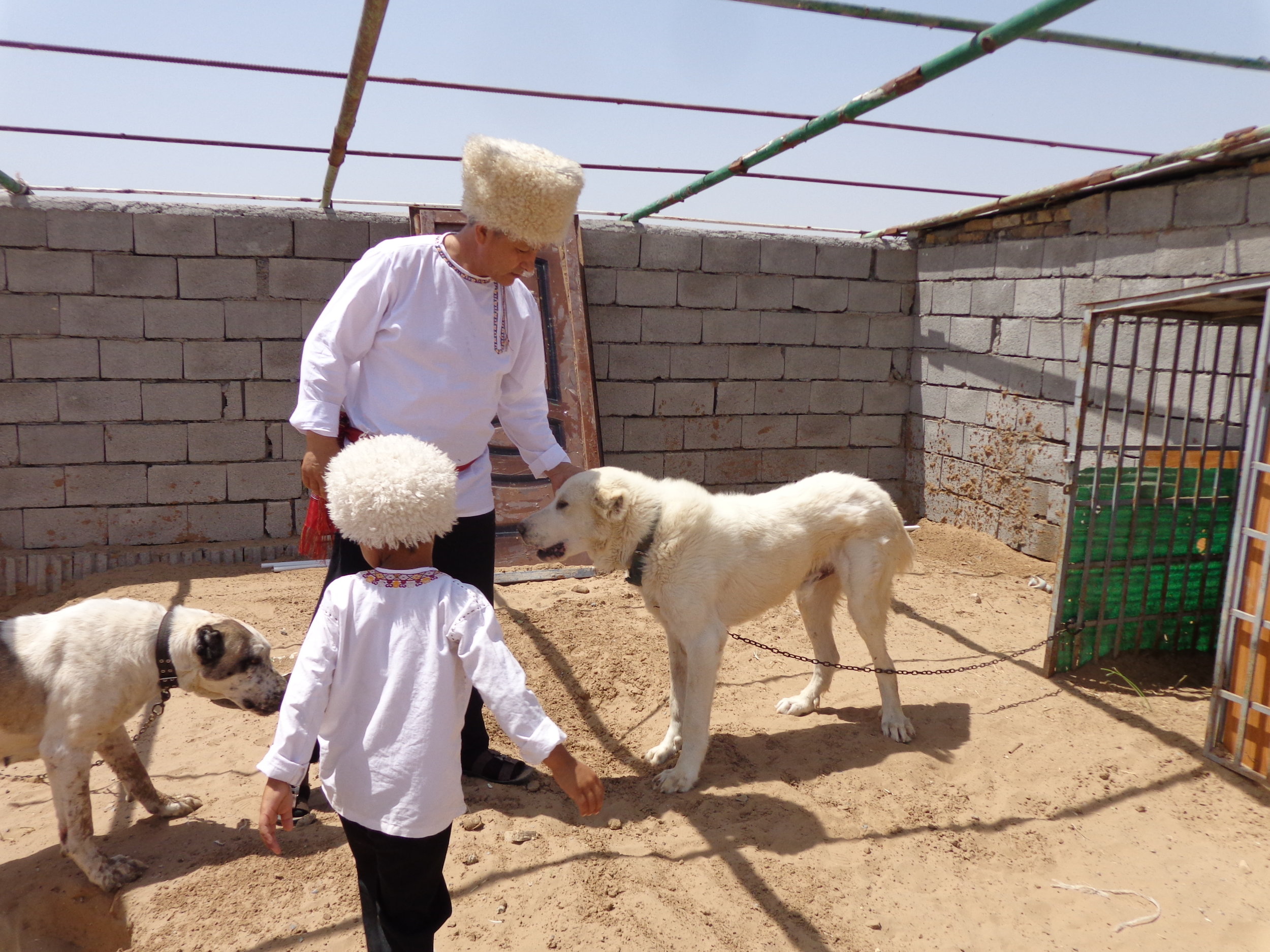
They also raise Alabai dogs.  The breed goes back thousands of years in central Asia and was a working dog in Turkmenistan who chased away the wolves.  It’s highly valued for personality traits, resilience, and guarding abilities.  I believe that they used to guard the nomads herds of sheep and goats against the wolves.  You can see the owner and his son with a one-year old Alabai (on the right) in the last photo.   

DSC04179.JPG

Horse Farm Lunch

We had lunch at the horse farm and I enjoyed watching them cook lunch as much as I enjoyed the horses.  In fact, lunch was being cooked as we had our horse showing and the cooking was nearby.  I kept going back and forth between watching the cooking and watching the horse showing.

They used four cooking fires but I was most curious about the first one, which you can see in the first photo.  That fire was really a blaze for some time before it calmed down.

DSC04130.JPG

The second photo was quite a bit later and you can see all four cooking fires.  If you look into the first cooking pot, you can see the naan (bread) that was cooked for our lunch.  They had a huge fire and when it calmed down, the stuck the naan to the insides of the cooking oven and the naan stayed stuck there until cooked and taken out to eat.  The entire inside along the rim was filled with naan.  You can see the big glove that the woman used to input and retrieve the naan.  The naan was excellent.

DSC04163.JPG

You can see more of the cooking crew in the third photo and also see that I wasn’t the only one very interested in the cooking.  Nora was probably discussing how the heck they get the naan into the stove and then how they get it back out – without burning themselves.  You can see some naan stacked on the table.

DSC04159.JPG

Vicky and our friend Patty are enjoying the first rounds of lunch in the fourth photo.  We were served lots of fresh vegetables, fresh naan (bread), and vegetable and meat soup.

DSC04185.JPG

Plov was the main course and you can see my plate of it in the last photo.  It’s rice with meat and vegetables along with yogurt (like sour cream) and chives.  It was delicious.

DSC04186.JPG

Ashgabat at Night

We are still in Ashgabat.  I didn’t get much opportunity to get out at night but the area of central Ashgabat, the white-marble area, is really lit up at night.  They light the buildings, the fountains, the roadways, the monuments, and it’s really a sight to see.  I didn’t have much opportunity to take photos and these aren’t that nice but it will give you a glimpse of Ashgabat at night.

The first photo is a moving bus photo on a drive home from dinner.

DSC04054.JPG

The second photo was from the balcony on our hotel room.

DSC04053.JPG

The third photo was from near a restaurant where we had dinner one night. 

DSC04253.JPG

The fourth photo is a moving bus photo.  I think this monument was just in a roundabout in the road.

DSC04260.JPG

The last photo is the Palace of Happiness or Wedding Palace.  This changed colors from red to yellow to green to gold, etc.  Also we had dinner in the Wedding Palace restaurant, which you can see in this photo, and that is the next post.  Also, as a reminder, this was the fourth question on the Ashgabat Quiz, so you can go back and look at the building in the daylight.

DSC04251.JPG

Wedding Palace Dinner

This was our dinner in the Palace of Happiness or the Wedding Palace.  It was called the Bagt Kosgi Restaurant, but I’m not sure what that means in Turkmen.   

Vicky is walking into the restaurant area in the first photo.  There were some dancers on the right side of the grand piano to greet our arrival.  One other person ate in this restaurant while we were there.

DSC04227.JPG

We were treated to music and dancing during our meal and evening here, but then they took it up a notch.

DSC04231.JPG

You can see the food that greeted us on our arrival to our tables.  Everything was fresh and delicious.  We also had vegetable soup and beef, chicken, lamb and potatoes.

DSC04230.JPG

The entertainment crew dressed us all up in Turkmen clothing and we all went through a mock wedding ceremony with all the drama and excitement.

You can see Vicky and myself dressed up as Turkmen in the fourth photo. 

DSC04241.JPG

I don’t want to get too political but I will say that if our country wants to deal with the likes of Putin and Kim Jong Un, we need to send the three guys in the last photo, not an ex game-show host.

DSC04238.JPG

These guys mean business and take no prisoners…

Dasoguz

We flew from Ashgabat to Dasoguz which is in far northern Turkmenistan.  Dasoguz (formerly Tashauz until 1992) is the capital of the Dasoguz Province and the city is only about six miles from the Uzbekistan border.  We had lunch in Dasoguz and drove to the border, so it was a short time.  I’m going to include a couple of posts just to wash Ashgabat out of everyone’s mind regarding what Turkmenistan is all about.

Dasoguz was originally a fort and a stop on the silk road, due to being an oasis with water.  Dasoguz means “Stone Spring” in Turkmen.  It became a town in 1924 but really developed after the construction of the railroad in the 1950s, under Russia.  Dasoguz has a cotton gin, food-processing plants, vehicle repair works, and is a center of carpet making.  Cotton, alfalfa, grains (sorghum, barley, rice, millet) and melons are produced in this area.  Silk production is also practiced.  The population is perhaps 250,000 people.

I had very little opportunity to take photos during this drive but I’ll give you some that I have something to say about.  Again, these are mostly moving bus photos, so not great.

After being part of the USSR for centuries and even now as Turkmenistan, and while not as glorious as Ashgabat, Dasoguz still has its monuments, as you can see in the first photo.

DSC04268.JPG

Dasoguz also had some interesting buildings, so while a long way from Ashgabat, it did not appear to be a “backwater” town.  I found some buildings quite interesting such as in the second photo.

DSC04269.JPG

We at lunch in the hotel in the third photo.  It did remind me a bit of Ashgabat as we were on our way out of Turkmenistan.

DSC04273.JPG

I was really excited to get the fourth photo: some real food and fuel processing plants, or real work being done with a real purpose.

DSC04283.JPG

The housing on the rest of the way to the border looked like below, except for some out in the fields which I couldn’t tell if it was housing or some agricultural outbuildings.

DSC04296.JPG

Dasoguz to the Uzbekistan Border

We drove from Dasoguz to the border crossing between Turkmenistan and Uzbekistan.  It was a short drive but life did look a bit different and since we saw so little of Turkmenistan outside of Ashgabat, I will again include this one post of this drive.  Once again, these are moving bus photos, so not award winning photographs. 

In the first photo, many of the houses that we saw had gardens.  The houses were, for the most part, simpler than housing that we had seen up to this point.

DSC04288.JPG

This was just an intersection that we passed on the drive in the second photo.  Some houses don’t have green roofs and the woman in the lower right is hanging laundry out to dry.

DSC04298.JPG

The third photo does not show the simplest housing that we saw, but it is certainly more humble than what we had seen before this drive.

DSC04299.JPG

This was still farming country but the crops did not look as full as earlier places we visited.  I think this land is more marginal and gets less water.

DSC04307.JPG

When we got to the border, there were many dozens to perhaps hundreds of people waiting around to cross the border.  From what we understood, these people are locals who are just taking goods across the border for someone else or to sell themselves in Uzbekistan.  It sounded like that was not legal but they would have a story that allowed them to go across the border with limited amounts of goods.  At any rate, these folks were evidently last priority at the border crossing.

DSC04313.JPG

We crossed from Turkmenistan to Uzbekistan here but it took us two hours.  Our guides said that it could take up to four hours.  The longest portion of time, by far, was getting clearance from Turkmenistan to leave.  The longest processing time for a person in our group was Vicky.  She was the only person that they took an extended time to process, as in about forty-five minutes.  The rest of us took just a few minutes each.  They never said what the problem was with Vicky but something with her passport or visa didn’t come up right on their computer.  Our guide and I stayed with her and there was no drama, just a very long wait.  We passed through Uzbekistan’s border process very quickly and felt glad to be in Uzbekistan.


Nukus, Karakalpakstan

We drove from Dasoguz and crossed the border into Uzbekistan.  We then drove to Nukus to spend one night.  What we learned was that although technically we were in Uzbekistan, we were in Karakalpakstan or the land of the Karakalpaks.  It’s called the Autonomous Republic of Karakalpakstan.  It occupies the northwest portion of Uzbekistan and is Uzbekistan’s largest region.  Our Uzbek guide said that Uzbekistan allows them to operate autonomously and elect their own officials and make their own laws – as long as they don’t conflict with any Uzbek laws.  For my part, I had never heard of Karakalpakstan before I arrived there.  The Russians never designated them as a large enough population to be their own republic.

Karakalpakstan was an area of nomadic herders and fishers and thrived from 500 BC to 500 AD.  They had extensive water from rivers that flowed into the Aral Sea, a rich delta, a branch of the Silk Road, and a great Islamic center of learning.  This area was ceded to the Russian empire in 1873.  Under the Soviets, water was diverted to areas upstream to grow cotton and the rivers here got diminished flow.  They still have agriculture here today but it is suffering. 

Nukus, the capital of Karakalpakstan, became a closed city under the USSR.  The Red Army had a Chemical Research Institute here which was a major research and testing center for chemical warfare weapons.  The research institute was dismantled by the U.S. Department of Defense in 2002.  The Soviets developed Nukus into a modern Soviet city with broad avenues and big public buildings by the 1950s.  

While we only spent an afternoon and the following morning in Nukus, it was obvious to us that the Nukus Museum of Art was their number one attraction.  It is also known as the State Art Museum of the Republic of Karakalpakstan but more commonly, we gathered, known as the Savitsky Museum.  Igor Savitsky was a Russian painter, archeologist, and art collector.  He first went to Karakalpakstan in 1950 on an archeological expedition but was fascinated by the culture and people of the steppe and he stayed here.  Perhaps the most remarkable story we heard was that he flaunted the orders from Stalin and smuggled Russian avant garde art and other Russian and non-Russian art to Nukus and kept it hidden from the KGB.  That was the advantage of being in one of the poorest and most remote parts of the USSR.  The museum’s collection today amounts to around 100,000 objects including paintings, sculptures, artifacts, textiles, jewelry, graphics, and antiquities from Khorezm’s ancient civilization to works of contemporary Uzbek and Karakalpak artists. 

You can see the Museum’s main hall (of three halls) in the first photo.  The second photo was taken just inside the building but I didn’t take any more photos.  I’m sure they can be seen online.  

DSC04344.JPG
DSC04348.JPG

We stayed in the Jipek Joli Hotel in Nukus.  I walked the surrounding area in the morning and our small hotel was in a neighborhood area.  The third photo is one of the streets by our hotel that I walked.  They were mostly dirt roads but neat and clean and most houses had some sort of garden, fruit trees and grapes. 

DSC04334.JPG

Vicky and I walked until we got to one of the big wide Russian avenues.  The fourth photo is what we saw during the morning rush hour.  These vehicles act as taxis or mini-busses.  The lines of them were long in many directions.  One interesting fact is that they are all “Chevy’s”.  When the USSR collapsed, this area had a Daewoo car factory.  Daewoo was a South Korean company.  Anyway, the factory evidently got abandoned or came up for sale and was purchased by Chevrolet.  The cars are the same cars produced during the Soviet times but now they say Chevy on them.  It felt just like home. 

DSC04342.JPG

In the last photo, what can I say.  Rich town or poor town, you have to have a cemetery.  This one was long and diverse but I’ll only include this one photo. 

DSC04322.JPG

Nukus Family Lunch

We had lunch in Nukus after visiting the Savitsky Museum.  Lunch was in a private home of a Karakalpak family.  We don’t know if our tour company didn’t trust the restaurants or what but we really enjoyed our meal in a family setting.

The first photo was entering the home.  I included this because I found the layout interesting.  We first saw a big wall from the outside.  We went through a door to get to this point.  The wall is the wall on the left.  I’m not sure why such a high wall with nothing inside of it but the house.  In other areas where we saw this – and it was common – they had gardens and animals inside the wall.  It didn’t matter, I just found it interesting.

DSC04352.JPG

You can see the table as we arrived in the second photo.  We started out with lots of fresh fruit and vegetables, several kinds of nuts, and dried fruits.  We were served a big meal and it was all very good and fresh.

DSC04353.JPG

The Karakalpak woman of the house is in the third photo and you can see the other end of the dining room.

DSC04355.JPG

We had Karakalpak music with lunch and they featured throat singing by the guy on the right.  The only other time we have heard throat singing was in Mongolia.

DSC04358.JPG

At some point, we got (had) to get up and dance.  In addition to Vicky, I had two other partners who you can see in the last photo.  These were the daughters of the woman in the third photo.

DSC04360.JPG


Khiva

We are now in Khiva, Uzbekistan.  Khiva was an important historical town on the Great Silk Road.  It’s sandwiched between the Kara-Kum and the Kyzyl-Kum deserts.  It was famous also for its long and brutal history as a slave trading post.  Our guide did note however, that under Islam, slaves had benefits and therefore were more like servants than slaves.  The slave trade continued here until 1873.  It might still be hard to determine exactly what ancient Khiva was like as the Soviets restored this in the 1970s, so it’s bound to be cleaner and neater than it had been originally.  Still, the town is a busy array of mosques, madrassahs and tiled minarets with lots of souvenir sellers in many of the streets.

According to legend, Khiva was founded some 2500 years ago when a son of Noah, Shem, discovered a well in the middle of the desert and exclaimed “Khi-wa”, roughly translated as “sweet water”.  There are also other stories about how Khiva got its start but none would be true were it not for having a source of water.  Khiva has been a UNESCO World Heritage site since 1990.

Khiva is split into two parts.  The outer town, called Dichan Qala, was formerly protected by a wall with eleven gates.  That wall and the gates are gone today.  The other part of Khiva is the inner town, called Itchan Qala.  Inner town is where we spent almost all of our time in Khiva.  Itchan Qala has a wall around it still that is one and a half miles long.  It used to have a moat around it as well.  Today about 2,500 people live inside the inner town while Khiva as a whole has about 50,000 people.  Itchan Qala or inner town is today a living historic town.  It has Islamic architecture that was built over a span of hundreds of years with some 50 historic monuments and maybe 250 old houses, mostly dating from the 18th or 19th centuries.  Much of what we saw was rebuilt but it was a fascinating place to visit. 

You can see Vicky and a fellow traveler at the south entrance to Inner Town in the first photo.  Our hotel was right across the street from here.

DSC04401.JPG

The second photo is to the left of the south entrance and you can see that it was a formidable wall.  The original moat would have been to the left of the wall.

DSC04565.JPG

The view of the wall in the third photo is near the west gate, looking north.  You can see some of Dichan Qala, or outer town, on the left and behind the inner town.

DSC04545.JPG

The fourth photo is 180 degrees from the third photo.  In this photo, you can see the western entrance on the right side.  The west gate was the main entrance to inner town.  The Kyzyl-Kum Desert is in the distance.

DSC04551.JPG

The last photo is from the wall above the western gate looking east at inner town.

DSC04546.JPG

So this was just an introduction and overview of Khiva.  We were here for two days and enjoyed it very much.  There will be more posts from Khiva.


Khiva Highlights

We are in Khiva and I will try to make one post on some highlights.  It won’t be easy as the entire Ichan-Qala, inner town, was a highlight in itself.  I will break down our time here in different ways, but here are a few highlights.

The first photo was called the “Short minaret” or Kalta Minor.  It was built by Mohammed Amin Khan, who according to legend wanted to build a minaret so high he could see all the way to Bukhara.  He started building it in 1851.  Unfortunately, the khan died in 1855 with his turquoise-tiled minaret only about one-third finished.  The next khan that succeeded him didn’t like it and so stopped construction, leaving more or less what we see today, a short, fat minaret.  Kalta Minor is about 48 feet wide at its base and 95 feet high.  It was supposed to be some 230 to 330 feet tall, depending on who you believe.  This was Vicky’s favorite landmark in Khiva.

DSC04474.JPG

I’m not sure which mosque and madrassah are in the second photo.  This was near the south gate so we passed this many times on our walks into and out of inner town.  This photo was the first evening that we arrived, in very late afternoon.

DSC04413.JPG

I’m also not sure which entrance is shown in the third photo but I believe it’s part of the Kuhna Ark which was the Khiva rulers’ own fortress and residence, within the inner town, sort of a town within a town.  It was first built in the 12th century but was then expanded by khans in the 17th century.  It included the khans’ harem, mint, stables, arsenal, barracks, mosque, and jail.

DSC04433.JPG

The fourth photo was taken from the watchtower of the Kuhna Ark.  At the back of the throne room, a door in the wall led up a flight of steps to the watchtower.  We had to pay extra for this but it was well worth it.  The lower portion of the photo is all part of the Kuhna Ark.

DSC04548.JPG

The last photo is Pakhlavan Mahmoud Mausoleum with its emerald green dome topped with a large brass finial.  It’s a shrine to Khiva’s patron saint who was a fur hat maker and a famous poet.  The mausoleum is the burial complex of the Khiva Khans.

DSC04574.JPG


Khiva Micro

In Khiva, it might seem like we wandered around and took in all the big and glorious sites.  But really, we traveled around inner town slowly because there was so much to see if you just took the time.  I will just make this one post to give you some idea about things that I found interesting and took some time to enjoy.

As we were walking through the south gate the first evening, I stopped and looked up – to see what you can see in the first photo.  There are arches and domes and all curved surfaces, all done with rectangular bricks.

DSC04402.JPG

We saw lots of tile work like in the second photo but I never tired of stopping to give it a close inspection.  Can you imagine it back in the day?

DSC04451.JPG

The third photo, like the second photo, is in the Khans or Kings area of the inner town.  This is looking up at the ceiling which is well preserved due to its protected situation.

DSC04449.JPG

The fourth photo I really liked.  This is just a patch of inner town street.  It’s made of rocks and you can see the wagon ruts in the rock surfaces.  One rut across the bottom and two ruts across the top.  I wonder how many wagons had to drive this street to get those ruts embedded in the rocks.

DSC04506.JPG

The last photo is a piece of naan that we had for dinner.  But it looked like all the other naan we had.  It was cooked in the same way as we saw at the horse farm.  It always had this pattern and all those tiny holes in it.

DSC04569.JPG

Djuma (Friday) Mosque

I will focus on just one Khiva mosque in this post.  I want to point out some things about how life was done rather well way back in the early days.  This is an original building and has not been refurbished.  I was fascinated with how well they dealt with everyday common issues back in the days before such things as steel, technology and power grids.

This is the Friday Mosque which is in the central part of the inner town.  It was erected late in the 18th century over the ruins of previous construction.  The mosque can be entered from four sides.  The mosque is about 180 feet by 150 feet, all in one room.  It has a flat ceiling supported by 215 wooden pillars.  We did not see any other mosques like this one but I understand that ancient Arabian mosques were similar as well as some others.

These are some of the things that impressed me about this seemingly simple mosque.  Light and air ventilation were provided by three openings in the ceiling.  They had light during the day and even during the night during periods around a full moon.  The mosque had great acoustics so that people in the far corners could still hear.  These things were all low technology but clearly effective.  While this day was extremely hot, it was very pleasant inside this mosque and it did have good acoustics.  I’ll point out some other things as I go through my photos.

This is the outside of the Friday Mosque in the first photo.  The minaret is 170 feet tall.  The walls of the mosque are brick.  You can see the north opening to the mosque just to the left of the minaret. 

DSC04490.JPG

The second photo is just a shot of as much of the mosque as I could get into one photo from one wall of the mosque.

DSC04487.JPG

You can see one of the opening in the ceiling in the third photo, which allowed in light and air.

DSC04480.JPG

Our guide told us that the mosque was arranged so that the Imam or preacher could see into all four corners of the mosque.  The preacher’s podium can be seen in the fourth photo.

DSC04482.JPG

The 215 wooden pillars are mostly from the 18th century and mostly elm trees according to our guide.  You might notice, in most photos, that the pillars stand on rocks.  That is because wood was scarce and precious and they didn’t want termites to ruin the pillars.  Some pillars were recycled from medieval buildings and date back as far as the 10th century.  Our guide said that the pillar in the last photo was apricot.  I have never seen an apricot tree that tall and straight so that is very impressive.  Each pillar was carved differently from all others.

DSC04484.JPG

Khiva Food

We are in Khiva and we had some great food in inner town at the restaurants.

The first photo was at lunch our full day in Khiva.  It was pasta with meat, vegetables, and yogurt.  I also love the plate and the table cloth.  It was very good pasta.

DSC04538.JPG

We were dining outside in the second photo at Farrukh Tea House.  It was still warm and we beat the dinner crowd but it was such a nice place to dine.  You can see Vicky, Nora, Patty and Ron, part of our group of friends.

DSC04570.JPG

This was one of our dinner dishes in the third photo which was noodles, vegetables, meat and broth in a bowl.

DSC04572.JPG

The ladies had pumpkin dumplings which you can see in the fourth photo.

DSC04573.JPG

The last photo was earlier in the afternoon.  We were hot and stopped into a tea house for a beer.  I specifically put all those thousand dollar som notes down to show that’s what my beer cost: 15,000 som. (or about $1.80 U.S.)  We had to carry a lot of cash around to pay for things in Uzbekistan.

DSC04560.JPG


Modern Silk Road

The ancient silk road was a web of trade routes connecting Asia with the Middle East and southern Europe.  Silk was an ideal good to trade because it was very light to carry a long distance and had a high value.  But the silk road traded all sorts of goods.  They traded woolen goods and carpets, gold, silver, and precious stones, glass items, skins, cotton fabrics, embroidery, vases, bowls, glasses and dishes, medicines, perfumery, cinnamon, saffron, skins, tea, food items, dyes, ivory, sugar, animals, vegetables, wine, and more.

While nothing that I’m aware of is still delivered by camel caravans across the deserts, goods are still made and still shipped and people still sell goods all along the silk road.  Khiva was no exception.

The main streets in Khiva’s inner town were lined with merchants.  In the first photo, you can glimpse on the right side and see that warm hats were one of the most popular items.  I guess I was surprised since the temperature was in the 90’s but I would assume that it gets very cold here in the winter.  Cold winters plus I think those hats are traditional. 

DSC04471.JPG

The truth is, I didn’t have to wander around town looking for merchants.  I just followed Vicky around and got plenty of photos.

DSC04542.JPG

There has been some shifting of vendor appeal since our grandchildren, as you can see in the third photo.  But the jewelry vendors are still in play as you can see in the fourth photo.  

DSC04557.JPG
DSC04544.JPG

I will admit that even I found many items appealing.  The last photo is some pottery and I liked the looks of it.  There are also Khiva paintings behind the pottery. 

DSC04541.JPG

Khiva People

My photos have already shown people in Khiva but I thought I would add another post with some specific comments about some of the people that we saw in Khiva.

The group in the first photo my favorite group that we met in Khiva.  It started when the woman on the right stopped to take our photo, as you can see in the photo.  This group of women were Uzbeks who were on vacation visiting Khiva.  We had a long chat with them, through our interpreter.  Eventually, they did a dance for us.  Vicky responded and we sang a song for them: “Take me out to the ball game”.  It was a very nice encounter.

DSC04496.JPG

The next two photos were early evening photos while we were out for a walk through inner town.  The merchants had all closed shop and gone home for the day.  But since 2500 people live in inner town, it’s not empty.  You can see a dad or grandpa taking three young ones out for a bicycle ride in the second photo.  Lots and lots of people sat out on the porch steps in the evening, like in the third photo.  I’m sure they were escaping the heat of their homes. 

DSC04417.JPG
DSC04406.JPG

People often sought to escape the heat in the middle of the day too.  You can see a bunch of men in the fourth photo sitting and talking under the shade of a tree around noon.

DSC04467.JPG

I don’t know that I would describe the Uzbeks as “fashionable” on the whole.  But the vendor in the last photo would certainly get my vote for making a fashion statement.

DSC04468.JPG

Kyzyl Kum Desert

On this day, we drove from Khiva to Bukhara.  This was a main route for merchants for centuries on the Silk Road.  It didn’t feel like a camel caravan in our air-conditioned bus but it was a long driving day and we got a sense of traversing the terrain of cascading sand dunes and undulating plains.  The temperature was in the 90’s and I was glad I had an automated camel. 

Khiva lies west of the Amu Darya (ancient Oxus River) River.  It’s between the Karakum Desert to the south and the Kyzylkum Desert to the northeast.  But knowing this didn’t prepare me for the size of the Amu Darya River which you can see in the first photo.  I was expecting something much smaller than this.  It’s no wonder that people stopped in Khiva, coming from either direction.

DSC04387.JPG

Since the Khiva area has water from this broad river, they have plenty of agriculture.  We saw this all over Central Asia but I just happened to get a decent photo here.  The farming was on a large scale and mostly done by large tractors.  But once the land was prepared and the crops planted, it seemed like most of the work was done by hoe.  Our guide said that they were mostly weeding cotton and it was done by hand as you can see in the second photo.

DSC04583.JPG

The Kyzyl Kum (Red Sand) Desert is mostly in Uzbekistan but some of it is in Kazakhstan.  It has an area of about 115,000 square miles and lies between the Amu Darya and the Syr Darya Rivers.  It’s a plain that slopes towards the northwest which is where the Aral Sea lies.  It has a number of isolated bare mountains and several large enclosed basins.  The Kyzyl Kum gets 4 – 8 inches of rain annually, mostly in winter and spring.  The largest portion of the desert and sand ridges have plants growing on them which serve as pasture for sheep, horses, and camels.  It has a few oasis settlements within its boundaries as well as natural gas deposits and gold.

The last three photos (bus photos) are just to give you an idea of what the Kyzyl Kum Desert looks like.  It wasn’t particularly exciting, as deserts go.  We saw a few birds and animals and a few wind funnel clouds of dust.

DSC04605.JPG
DSC04612.JPG
DSC04618.JPG


Bukhara

We are in Bukhara.  Bukhara was a prominent destination along the Silk Road.  The city was officially founded around 500 BC but it was inhabited as the Bukhara oasis long before that.  It has long been a center of trade, scholarship, culture, and religion.  Bukhara was one of the main centers of the Persian Empire.  During the golden age of the Samanids (9th and 10th centuries), Bukhara was the intellectual center of the Islamic world. 

Bukhara is the city of museums and contains over 140 architectural monuments of the Middle Ages including mosques, madrassas, minarets, and trading centers.  Don’t worry, I’m not going to show them all.  I will try to isolate a couple of posts to give you a sense of Bukhara but it won’t be enough to keep you from visiting on your own.

The Chasma Ayub Mausoleum is in the first photo.  It’s a religious building in the center of Bukhara.  It consists of the mausoleum and a holy spring.  It also has a museum of water.  The story goes that the Prophet Job (yes, that Job) was traveling along the road to Bukhara in a period of strong desert winds and intense drought.  People prayed to Allah for a miracle.  Job came along and struck the ground with his staff and healing water sprang up.  The spring saved the people of Bukhara.  People still come here and still believe that the water from the spring is pure and healing.  I declined to sample the healing water as the sanitary conditions gave me some uncertainty!

DSC04646.JPG

The Ismail Samanid Mausoleum is in the second photo.  It was built between 892 and 943 and is the final resting place of Ismail Samani, a powerful amir of the Samanid Dynasty, one of the last native Persian dynasties that ruled in Central Asia in the 9th and 10th centuries.  The building is a landmark shrine.  It’s a baked-brick cube covered with a dome.  The walls are six feet thick.  The interior is ornamented with various geometric shapes.  This is perhaps the only building that pre-dates the Mongol invasion.  Genghis Khan and the Mongols leveled Bukhara.  But this building was out on the edge of town at that time plus it was in a cemetery and the Mongols had some aversion to the spirits of the dead, so left this building alone. 

DSC04662.JPG

The Ark Citadel is a massive fortress located in Bukhara.  You can see what’s left of it in the third photo.  It was the center of the original town of Bukhara.  It was initially built around the 5th century but on top of earlier buildings.  It was a town within itself with some 3,000 residence.  It was inhabited by various royal courts that controlled Bukhara.  It was a military fortress but had galleries, rooms, and terraces.  The perimeter walls are 2,590 feet around covering an area of about ten acres.  The walls are 52 to 66 feet tall.  The Ark was occupied and full of action from the 5th century to 1920 when the Red Army (Russia) bombed it, destroying much of it.  We heard plenty of sordid stories about events in the Ark over the centuries.

DSC04673.JPG

The Moschea Bolo-khauz Mosque can be seen in the fourth photo.  This is an 18th century mosque that is still an active mosque today.  It was built in 1712 but there are a couple of stories about who built it and why.  It has a vibrantly decorated wooden porch with vividly painted columns and intricate tile work.  Khauz means pond and Bolo-Khauz is Children’s Reservoir.  The pond is one of the most ancient parts of the complex.  In early days, these reservoirs were the water source for much of the population.  Unfortunately, they also became the source of many diseases.  

DSC04677.JPG

Covered bazaars can be seen in the last photo.  In the 16th century, the Sheibanids made Bukhara the capital of their state.  They did large-scale construction and one type of project was covered bazaars.  They became a symbol of the city and its importance on the Great Silk Road.  Trade complexes were built all over Bukhara, mainly where several roads intersected.  Only four such trading domes still survive today.  We went inside several and you can buy whatever you want inside the bazaars. 

DSC04730.JPG

Hotel Amelia

We stayed at the Hotel Amelia in Bukhara.  It was a small boutique hotel in the center of the old part of Bukhara.  This was originally a family home and is about 200 years old.  It’s decorated in the Uzbek national traditional style, with some of it still original including some wall paintings and wood carved ceilings in the rooms and restaurant.  It was a two story house with odd hallways and attachments that must have added to and changed over time.  It also had a courtyard and an open seating area on the roof, with one wall and a view of the surrounding city area.  This hotel might not have had that many stars but the service was as good as any we have had anywhere in the world.  The people were fun, friendly, and as welcoming as possible.  The staff all treated us like family. 

Vicky is sitting in the main room of our hotel room in the first photo.  The bathroom is to the right and the bedroom is to the left of her in the photo.

DSC04644.JPG

The bedroom is the next two photos.  It was my understanding that the wall paintings and the wood ceiling are original.  It felt pretty exotic.

DSC04748.JPG
DSC04749.JPG

The restaurant where we had breakfast each morning is in the fourth photo.  I believe that this whole room is original and it was a great place to eat breakfast and sip our tea or coffee.

DSC04641.JPG

We ate dinner on the roof of the hotel one night.  We separately shopped at the markets for different things to bring to dinner: cheeses, melons, chips, etc.  Our good friends Ron and Patty are on the left of Vicky and Nora is on her right.  You might notice that we have beer, vodka, and brandy on the table.  I’ll explain.  I bought the beer since it was about 98 degrees that day.  Nora bought the brandy in Turkmenistan but we hadn’t drank it yet.  The hotel staff gave us the bottle of vodka because they felt bad about something they hadn’t done.  At any rate, dinner on the roof was delightful and we only had to navigate one narrow stairway and go around one corner to get back to our bedroom.

DSC04750.JPG

Po-I Kalyan mosque complex

We are in the old center of Bukhara.  Bukhara was a prominent destination and this is the spiritual center of the city.  It consists of a madrasah, a minaret, and a mosque.  The madrasah and the mosque entrance sit at opposite sides of a large plaza and the minaret is between them, but off to one side.  I’ll talk about each of these as they are really three separate monuments that are grouped together.  The next day, the plaza between the madrasah and mosque was all closed off and they were filming a movie with dozens of actors in period costume along with camels and tents and the whole nine yards.

The Miri-Arab madrasah (school) is in the first photo.  The madrasah was built in the early 1500’s and is related to sheikh Abdallah Yamani from Yemen, the spiritual guide of the sheybanids.  This madrasah is still an active madrasah today and where future imams and religious mentors receive their education.  This was the only spiritual education center in the USSR that begun to function after WW II.  You can see different stone mosaics with geometric, vegetative and calligraphic writings and patterns.  Since this is a working school, tourists are not allowed.  But I went into the entry hall and looked around but really couldn’t see very much from there.

DSC04705.JPG

On the opposite side of the large plaza is Kaylan mosque but between the madrasah and mosque is the Kalyan Minaret which is the monument that was built first.  The 158 foot high baked-brick tower was constructed in 1127.  It was designed to call the Muslim faithful to prayer five times a day.  It was also a landmark for travelers along the Silk Road.  When Genghis Khan arrived about 100 years after the construction, local legend says that the great Khan looked up from the base to the top of the tower and the steep angle caused his hat to fall off.  Admiring the audacity of the tower and having bowed down to pick up his hat, Khan ordered it spared from destruction, which the Mongols did to the rest of the city.  One thought is that Khan really wanted it left in order to use it as an observatory to watch for invading armies.  In the 16th century, the mosque and madrasah were built around the minaret.  You can see the minaret in the second photo.  It was nicknamed the “Tower of Death,” as it was used for public executions by throwing people off the top of it.  That started early and went on until the last known execution around 1920 during the Russian Revolution.

DSC04704.JPG

The Kalyan mosque is the largest, by far, of the three monuments.  It is one of the oldest in central Asia.  The mosque was built at the beginning of the 15th century.  It has an entrance much like the madrasah in the first photo.  Inside is a huge courtyard surrounded by galleries and square columns covered with domes.  The building accommodates up to 10,000 people.  We didn’t actually get to go into the mosque itself but we walked all around the courtyard and into the galleries. 

You can see Vicky about the center of the courtyard in the third photo.  The mosque is behind her on the left side.

DSC04707.JPG

The fourth photo is also from the courtyard but right next to the mosque looking back towards the entry way.  The minaret can also be seen in the photo.

DSC04717.JPG

The last photo is in the galleries to the sides of the courtyard.  There are 208 strong pillars which support 288 small domes.  There is also one open dome where light comes in and from a certain angle, you can see the minaret.

DSC04709.JPG

A Day in the Life

Our tour company, Overseas Adventure Travel (OAT) usually designates one day of the trip as “A day in the Life”.  On that day, we usually get very involved with locals in various ways, trying to experience what their daily lives are like.  This post and the next couple will be from the day in the life day for our central Asia trip.  We started the day by driving out of Bukhara into the country.  We drove to a small farming village called Nayman.  There we met with the Village Administrator.  She runs the village and it is an elected office.  From there we walked some of Nayman before going to one home for some chores and lunch.

We were leaving Bukhara on our way to Nayman in the first photo.  You can see the agricultural field in the background and realize that this is big-time, big-tractor farming.  But much like the people hoeing the cotton by hand, sights like the first photo were common.  People used all sorts of rather primitive conveyance.

DSC04621.JPG

Many people have commented about how clean things were in central Asia.  Indeed they were but not without some effort.  You can see the second photo which I took as our bus was making a U-turn on the highway.

DSC04762.JPG

We were walking in Nayman in the third photo.  These two ladies were pitting apricots.  My assumption was that they were going to dry the apricots for their own use or for sale.  I was wrong.  They planned to feed the apricots to their goats.  They were going to crack, bake, and then sell the apricot pits.  We purchased some at other locations.  They were cheap and a very good snack.

DSC04766.JPG

People came out of their homes to check us out in Nayman.  I don’t think they get many tourists.  They seemed pleased to see us – for some reason. 

DSC04767.JPG

We stopped along the highway for a restroom break.  The place was like a small strip-mall.  Anyway, the guy in the last photo was cooking kabobs right on the edge of the parking lot.  They looked good but we were still full from lunch.

DSC04854.JPG